Robinson (Lake District) facts for kids
Quick facts for kids Robinson |
|
|---|---|
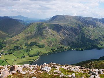
Robinson seen across Buttermere with High Snockrigg in front to the left
|
|
| Highest point | |
| Elevation | 737 m (2,418 ft) |
| Prominence | 161 m (528 ft) |
| Parent peak | Dale Head |
| Listing | Marilyn, Hewitt, Wainwright, Nuttall |
| Geography | |
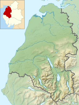
| Location | Cumbria, England |
| Parent range | Lake District, North Western Fells |
| OS grid | NY201168 |
| Topo map | OS Landrangers 89, 90, Explorer, OL4 |
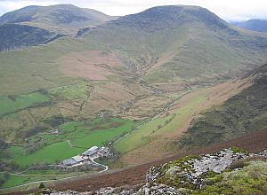
Robinson is a cool mountain, or "fell," found in England's amazing Lake District. Its southern side slopes down to the beautiful Buttermere lake, while its northern side faces the Newlands Valley. Many paths can take you to the top, starting from places like Buttermere village, the nearby Dale Head mountain, or other spots in the northern valleys.
Contents
Why is it Called Robinson?
The famous guidebook writer Alfred Wainwright said that Robinson got its name from a man named Richard Robinson. He bought land in the Buttermere area many years ago. This land included an unnamed hill, which then became known as "Robinson's Fell." Later, people shortened it to just Robinson.
What Does Robinson Look Like?
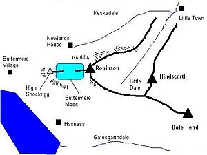
The North Western Fells are a group of hills in the Lake District, shaped a bit like an oval. Robinson is in the southern part of this area. A main ridge of mountains goes east from Buttermere, climbing over Robinson, Hindscarth, and Dale Head.
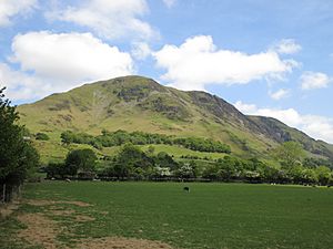
From Buttermere, Robinson looks smooth and rounded. But if you see it from Keswick or Newlands to the north, it looks very different! From there, you can see the steep "Robinson Crags" dropping from the top, almost like a big piece of the mountain is missing.
Slopes and Features
The western sides of Robinson lead down to Buttermere lake and village. Parts of these slopes are quite steep. There's a flatter area called Buttermere Moss, which is a bit marshy. Higher up on the western side is a smaller peak called High Snockrigg (1,725 feet). It offers amazing views of the Buttermere valley.
To the south of Robinson, you'll find Gatesgarthdale Beck and the road to Honister Pass. This side of the mountain is mostly smooth. Near the top, there are some interesting rocky dips called the Hackney Holes.
Connecting Ridges and Valleys
A ridge called Littledale Edge runs southeast from Robinson's summit, connecting it to the nearby mountain, Hindscarth. To the north of this ridge, the land slopes down into Little Dale. This valley runs northeast and has a stream called Scope Beck.
Robinson's northeast ridge is rocky near the top. It then becomes a grassy area called High Snab Bank, which goes down to Newlands Church and the small village of Little Town.
Keskadale valley forms the northwest edge of Robinson. The Newlands Pass road also goes through Keskadale, connecting Braithwaite to Buttermere. Near the top of this pass, you can see the beautiful waterfall called Moss Force.
What Rocks Make Up Robinson?
The rocks at the top of Robinson are part of something called the Buttermere Formation. These rocks are a mix of different types, like mudstone, siltstone, and sandstone, which have been moved and folded over time. Some parts of the mountain have large pieces of sandstone mixed with mudstone. The southern slopes of Robinson show signs of a huge landslide.
There was some mining for lead near Buttermere lake on Robinson's slopes. However, these mines were very small and didn't produce much. The mysterious Hackney Holes are now thought to be where a massive rock slide happened a long time ago. This slide caused the ground to deform, leaving behind these open trenches.
Reaching the Summit
The very top of Robinson is rounded and mostly covered in grass. There are two low rocky spots, and the one further west is the highest point, marked by a pile of stones called a cairn. There's another cairn on the northeast ridge, which might look like the summit from below, but it's not the true top.
Good paths lead to the summit from Buttermere, Littledale Edge, and the northeast ridge.
Views from the Top
From the summit, you can see many mountains in all directions. You can spot almost all the main groups of fells in the Lake District, except for the Far Eastern Fells.
How to Climb Robinson
Buttermere Village is a popular place to start your climb. A good path goes up through High Snockrigg. It can get a bit wet when crossing Buttermere Moss, but then it's a steady climb to the top. Another way from Buttermere starts at Hassness, going around Goat Crag to join the main path.
You can also start from the Honister Pass road. From there, you can walk directly north to reach Littledale Edge.
The northeast ridge offers a great walk from the Newlands valley, climbing up in steps. If you want to gain a lot of height quickly, you can drive to Newlands Hause. From there, you can climb to the right of Moss Force. You might lose the path for a bit in the marshy area, but then it's a rough climb to the summit. You can also walk around the marsh to the west from Newlands Hause to reach High Snockrigg for amazing views and a picnic spot.
 | Bayard Rustin |
 | Jeannette Carter |
 | Jeremiah A. Brown |


