Low Fell (Lake District) facts for kids
Quick facts for kids Low Fell |
|
|---|---|

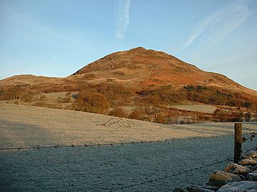
Low Fell from Thackthwaite
|
|
| Highest point | |
| Elevation | 423 m (1,388 ft) |
| Prominence | c. 270 m |
| Parent peak | High Stile |
| Listing | Wainwright, Marilyn |
| Geography | |
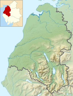
| Location | Cumbria, England |
| Parent range | Lake District, Western Fells |
| OS grid | NY137226 |
| Topo map | OS Landranger 89, Explorer OL4 |
Low Fell is a beautiful fell (a type of mountain or hill) located in the famous Lake District in England. It offers amazing views of Loweswater, a lovely lake to its south. To the north, Low Fell is next to another fell called Fellbarrow.
People often start their climb to Low Fell from the villages of Loweswater or Thackthwaite. The fell is mostly covered in grassy areas, but you'll also find some rocky spots near the very top. Low Fell has slopes that are quite steep on its south and east sides.
Contents
Where is Low Fell?
The Western Fells are a group of hills in the Lake District. They form a triangle shape, with rivers and valleys around them. Low Fell and Fellbarrow are found a bit away from the main group of these western hills.
Loweswater is a special lake because its water flows east into Crummock Water. Most lakes in the Lake District flow outwards. This means Loweswater doesn't divide the fells on either side of its valley. A lower ridge connects Burnbank Fell to Low Fell and Fellbarrow. This shows they are the last hills in the Western Fells.
Low Fell and Fellbarrow Ridge
Low Fell and Fellbarrow together form a ridge that is about two miles long. Even though it's called "Low Fell," it's actually the higher of the two! For a long time, people weren't sure which was taller. Alfred Wainwright, a famous writer about the Lake District, thought Fellbarrow might be higher. But new maps from the Ordnance Survey have confirmed that Low Fell is indeed taller.
The lowest point between Low Fell and Fellbarrow is a col just south of Fellbarrow. Because of this, the smaller tops in between are usually considered part of Low Fell. These smaller summits, moving south, include Smithy Fell (about 1,296 feet high) and Sourfoot Fell (about 1,350 feet high).
The very end of the ridge, looking down on Loweswater village, is quite rough. It rises to a small, neat top. Wainwright thought this was the summit, but he wasn't sure. This 1,352-foot top is sometimes called Loweswater Fell. North of this point, there's a slight dip before you reach the true summit, which is smoother and longer.
A smaller ridge branches off from Sourfoot Fell towards the southwest. It goes over a small bump called Loftbarrow before reaching Darling Fell (about 1,282 feet high). Darling Fell sits above the northern shore of Loweswater. Between Darling Fell and Low Fell is a small valley with a stream called Crabtree Beck. Generally, the western slopes of Low Fell are long and gentle. However, the eastern and southern sides are steeper and have more rocks.
The western edge of Low Fell is at Leady Moss. This is a low point that connects it to Burnbank Fell. From here, Dub Beck flows into Loweswater, and Black Beck flows northwest into the River Marron. A small road runs from the shore of Loweswater north to Mosser, marking the edge of the open fellside. To the east, the land drops quickly to the farmlands of the Lorton Vale. Raven Crag, below the summit, and Watching Crag, on Sourfoot Fell, are important rocky features.
What are the Rocks Made Of?
The rocks under the summit of Low Fell are part of the Loweswater Formation. These are made of a type of rock called greywacke sandstone. Below these, and sometimes showing on the eastern slopes, are layers of mudstone and siltstone from the Kirk Stile Formation.
Views from the Top
From the top of Low Fell, you can enjoy fantastic views! Wainwright described the view from the lower southern top. He noted that two cairns (piles of stones) lower down on the southern side offered even better views of the Loweswater Valley.
From either the true summit or the lower southern top, you can see Grasmoor across the Lorton Vale. You can also look down the Buttermere valley, where you'll spot Crummock Water and Buttermere lakes. Both tops of Low Fell have cairns marking them. The true summit is on a small rocky area surrounded by short grass and larger rocks.
How to Climb Low Fell
The easiest way to get onto the Low Fell ridge is from Thackthwaite in the Vale of Lorton. A footpath leads from the village, climbing up to a wall. Beyond this, there's an old track that curves up the hillside and brings you out at the top of Sourfoot Fell. From there, walking along the ridge is quite easy.
Another way to start is from the Mosser road. You can climb Darling Fell first, then join the main ridge. Wainwright also suggested following Crabtree Beck for a more direct climb up Low Fell.
Who Owns Low Fell?
Records show that Low Fell, Raven Crag, and the lands around them were once part of Oak Farm. These lands were owned by the Master and Scholars of Balliol College at the University of Oxford. In 1959, the ownership changed to John Gladstone Mitchel of Cockermouth.
 | Charles R. Drew |
 | Benjamin Banneker |
 | Jane C. Wright |
 | Roger Arliner Young |


