Fellbarrow facts for kids
Quick facts for kids Fellbarrow |
|
|---|---|

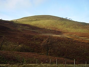
Fellbarrow from the slopes of Low Fell
|
|
| Highest point | |
| Elevation | 416 m (1,365 ft) |
| Prominence | c. 50 m |
| Parent peak | Low Fell |
| Listing | Wainwright |
| Geography | |
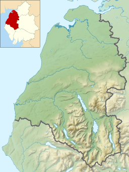
| Location | Cumbria, England |
| Parent range | Lake District, Western Fells |
| OS grid | NY132243 |
| Topo map | OS Landranger 89, 90, Explorer OL4 |
Fellbarrow is a small hill in the beautiful Lake District in England. It's located in the northwest part of the park. You can find it close to the town of Cockermouth and near Loweswater. Many people enjoy climbing Fellbarrow. The easiest ways to reach the top are from Low Lorton or Thackthwaite. From the very top, you get amazing views. You can see across the Lorton valley to other fells like Grasmoor and Whiteside.
Contents
Where is Fellbarrow?
Fellbarrow is part of the Western Fells in the Lake District. These fells form a triangle shape. The River Cocker is to the northeast. Wasdale is to the southeast. As you go west, the hills get smaller. They lead towards the coast of Cumberland.
Fellbarrow's Place in the Landscape
The main high fells are around Great Gable. Two big ridges spread out from there. They go around Ennerdale, which is a long, wild valley. The western fells look like a giant horseshoe around this valley. Fellbarrow and Low Fell are a bit separate. They are at the very end of the northern ridge.
Loweswater is a special lake in the Lake District. It flows east, towards the center of the National Park. Its water goes into Crummock Water. Then it flows north as the River Cocker. This means Loweswater doesn't divide the fells on its sides. A low ridge connects Burnbank Fell to Low Fell and Fellbarrow. This shows that Fellbarrow is one of the last hills in the Western Fells.
Fellbarrow and Low Fell
Fellbarrow and Low Fell make a ridge about 2 miles long. Fellbarrow is the lower hill at the northern end. Alfred Wainwright wrote famous guidebooks about the Lakeland Fells. He thought Fellbarrow might be the highest point of this ridge. But he wasn't completely sure.
There are other smaller tops on the ridge. These include Smithy Fell and Sourfoot Fell. Wainwright decided these were part of Low Fell. This was based on where the lowest point (or col) between them was. We follow that idea here.
Surrounding Areas
To the east of Fellbarrow is the Vale of Lorton. The River Cocker flows through this valley. It's a wide valley with farms and small woods. The village of Thackthwaite is closest to the fell. To the west are small streams like Mosser Beck. These also flow north and join the River Cocker. This area is mostly farmland. It's right on the edge of the Lake District.
North of Fellbarrow is a lower top called Hatteringill Head. Some guidebooks mention it. After that, the ridge drops down over Whin Fell. It then reaches a small road called Mirk Lane. Fellbarrow also has a short ridge going northeast. This ridge goes over Broadmoor Hill towards Low Lorton village. The fell itself is mostly round and covered in grass.
What is Fellbarrow Made Of?
The rocks under the top of Fellbarrow are from the Loweswater Formation. These rocks are made of greywacke sandstone. Below these rocks, you can sometimes see the Kirk Stile Formation. These are layers of mudstone and siltstone.
Reaching the Top of Fellbarrow
The top of Fellbarrow is a gentle, grassy dome. A fence crosses it. You'll also see an Ordnance Survey triangulation column. This is a small pillar used for mapping. There's also a cairn, which is a pile of stones.
Views from the Summit
From the top, you can see the Irish Sea and Solway Firth to the west and north. These are seen across the flat Cumberland plain. To the east, you get a great view of the North Western Fells. The ridge from Whiteside to Grisedale Pike is a highlight. You can also see Skiddaw and Blencathra behind them.
Further around, many fells fill the view. You can see the northern side of Ennerdale for its whole length. Behind it are Pillar and the Scafells. You won't see any lakes or tarns from the very top.
How to Climb Fellbarrow
There are a few ways to climb Fellbarrow.
Routes from the East
From Low Lorton village, a lane goes west. It connects to a track that leads to Hatteringill farm. This track gives you access to the northeast ridge. This ridge goes over Broadmoor Hill. From there, it's easy to reach the summit.
Another option is to climb Low Fell first. You can use the old track from Thackthwaite. Once on the ridge, you can either go north to Fellbarrow. Or you can climb both tops in one trip.
Routes from the West
From the west, there are no official paths on the fell. However, the OS maps show it as "access land." This means you can walk there. So, you could approach Fellbarrow from the Mosser road.
 | Emma Amos |
 | Edward Mitchell Bannister |
 | Larry D. Alexander |
 | Ernie Barnes |


