Yoke (Lake District) facts for kids
Quick facts for kids Yoke |
|
|---|---|

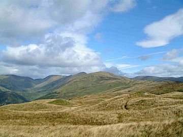
Yoke seen from the Garburn Pass track on
the approach from Troutbeck. The Troutbeck valley is to the left. |
|
| Highest point | |
| Elevation | 706 m (2,316 ft) |
| Prominence | 38 m (125 ft) |
| Parent peak | Ill Bell |
| Listing | Hewitt, Nuttall, Wainwright |
| Geography | |
| Location | Cumbria, England |
| Parent range | Lake District, Far Eastern Fells |
| OS grid | NY437067 |
| Topo map | OS Explorer OL7 |
Yoke is a mountain, also known as a fell, located in the beautiful Lake District in Cumbria, England. It stands 706 meters (2,316 feet) tall. You can find it in the eastern part of this national park, about 6.5 kilometers (4 miles) northeast of the town of Ambleside. Yoke is the southern end of a long ridge that stretches all the way from another mountain called High Street. The name Yoke likely comes from an old English word, geoc, which means "mountain ridge." This is similar to the German word joch.
Contents
Climbing Yoke
Yoke might not be the most famous mountain in the Lake District. However, many people climb it often. It is a key part of a popular walking route called the Kentmere Horseshoe.
The Kentmere Horseshoe Walk
The Kentmere Horseshoe is a long walk, about 19 kilometers (12 miles) in total. It involves climbing 1,100 meters (3,609 feet) uphill. This exciting route starts and finishes in the village of Kentmere. Along the way, hikers visit several other mountains. These include Kentmere Pike, Harter Fell, Mardale Ill Bell, High Street, Thornthwaite Crag, Froswick, and Ill Bell.
Starting Your Climb
Most people who climb Yoke directly start from the top of the Garburn Pass. You can reach this pass from either Kentmere or Troutbeck. Once at the top of the pass, you turn north. You then follow a wall over some wet ground to reach the mountain's summit. Some paths on Yoke's southern slopes have been repaired. This helps stop the paths from wearing away due to many walkers.
Yoke's Landscape
Yoke has some interesting natural features. One of the most striking is Rainsborrow Crag. This is a very steep cliff on the Kentmere side of the mountain. It drops about 300 meters (984 feet) down to the valley floor. These cliffs are so challenging that they attract expert rock climbers.
Hidden Tarn and Old Roads
Near the edge of Rainsborrow Crag, there is a small, less-known lake called Rainsborrow Tarn. It is thought that an old Roman road might have crossed Yoke's slopes. This road would have connected Ambleside and Penrith. Old maps sometimes show short parts of this road marked on the mountain. Yoke also shows signs of old quarrying. This means people used to dig for stone on both its Troutbeck and Kentmere sides.
The Summit View
From the very top of Yoke, you can enjoy great views. You can see Windermere, which is England's largest natural lake. You can also spot Morecambe Bay in the distance. For an even better view of these, walk about 100 meters (328 feet) south to a stone pile called a cairn.
What Else Can You See?
Looking west, you get a good view of taller mountains. These include those around Coniston and Langdale. The view to the north is partly blocked by the higher mountain of Ill Bell. However, you can just see the summit of High Street. If you walk about 150 meters (492 feet) northeast from the summit, you will reach Star Crag. From there, you can see Kentmere Reservoir.
 | Dorothy Vaughan |
 | Charles Henry Turner |
 | Hildrus Poindexter |
 | Henry Cecil McBay |


