Great Sca Fell facts for kids
Quick facts for kids Great Sca Fell |
|
|---|---|

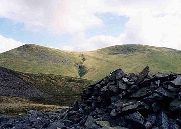
Great Sca Fell (right) and Little Sca Fell (left) seen from Meal Fell.
|
|
| Highest point | |
| Elevation | 651 m (2,136 ft) |
| Prominence | 13 m (43 ft) |
| Parent peak | Knott |
| Listing | Wainwright |
| Geography | |
| Location | Cumbria, England |
| Parent range | Lake District, Northern Fells |
| OS grid | NY291338 |
| Topo map | OS Landranger 89, 90 OS Explorer 4 |
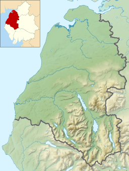
Great Sca Fell is a mountain, or 'fell', located in England's beautiful Lake District. It sits about 7 kilometers (4.5 miles) southwest of a village called Caldbeck. This fell is the tallest of a group known as the Uldale Fells. The other fells in this group are Longlands Fell, Meal Fell, and Great Cockup. Great Sca Fell is also one of the 'Wainwrights', which are 214 special fells described by Alfred Wainwright in his famous guidebooks. It's the smallest of the three 'Sca fells' in the Lake District, the others being Scafell and Scafell Pike.
Contents
About Great Sca Fell
The Uldale fells are known for their smooth, grassy slopes. They are often used as sheep pastures. These fells rise up in three main ridges from the lower lands to the north. Great Sca Fell is the highest point, reaching 651 meters (2,136 feet) above sea level.
Even though it's a 'Wainwright' fell and over 2,000 feet tall, Great Sca Fell doesn't quite meet the requirements for some other major mountain lists. This is because its 'prominence' (how much it rises above the land connecting it to a higher peak) is only 13 meters. The higher peak it connects to is Knott.
Twin Summits: Great and Little Sca Fell
Great Sca Fell actually has two main tops: Great Sca Fell and Little Sca Fell. Little Sca Fell is about 400 meters north of the main summit. It stands at 635 meters (2,083 feet) high.
Little Sca Fell has a larger pile of stones, called a cairn, at its top. It also has a strange dip in the ground that has been made into a wind shelter. The very top of Great Sca Fell is a wide, flat area. The highest point could be almost anywhere within a 15-meter circle. However, a small cairn marks the official highest spot.
Connecting Ridges and Rivers
Four ridges spread out from the summit of Great Sca Fell. These ridges connect it to nearby fells like Knott (to the south), Brae Fell (to the north), Meal Fell (to the west), and Longlands Fell (to the northwest). This makes Great Sca Fell an important spot if you're hiking these quiet hills.
The River Ellen starts on the western slopes of Great Sca Fell. It flows west until it reaches the Solway Firth, which is an inlet of the Irish Sea. Water from the eastern side of the fell flows into the River Caldew. This river then joins the River Eden, which also reaches the sea at the Solway Firth.
How to Climb Great Sca Fell
Most people start their climb of Great Sca Fell from a small road that runs along the northwest side of the Uldale fells. Good starting points include the small villages of Orthwaite and Longlands. You can either walk up the valleys or climb other fells first and then follow the connecting ridges to Great Sca Fell.
Views from the Top
From the summit of Great Sca Fell, one of the best views is to the north. You can see the wide Solway Plain and even the Scottish Borders beyond it. The view of the Lake District to the south is partly blocked by the large Skiddaw mountain range. However, you can still see the Bowfell group of fells in the distance, almost 30 kilometers away, through a gap in the hills.
 | Precious Adams |
 | Lauren Anderson |
 | Janet Collins |


