Armboth Fell facts for kids
Quick facts for kids Armboth Fell |
|
|---|---|
| Highest point | |
| Elevation | 479 m (1,572 ft) |
| Prominence | c. 25 m |
| Parent peak | High Seat |
| Listing | Wainwright |
| Geography | |
| Location | Cumbria, England |
| Parent range | Lake District, Central Fells |
| OS grid | NY297159 |
| Topo map | OS Explorer OL4 |
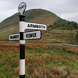
Armboth Fell is a beautiful fell (which means a hill or mountain) located in the famous Lake District in England. A well-known writer, Alfred Wainwright, even called it the very center of this amazing area! The fell gets its name from an old village called Armboth.
Armboth Fell is like a big, rounded tabletop, about three-quarters of a mile wide. It sticks out towards the east, near the large lakes of Derwentwater and Thirlmere. You might find it a bit wet and squishy underfoot in places, with lots of purple heather plants. The parts of the fell that face Thirlmere have many tall conifer trees planted on them.
Contents
Exploring Armboth Fell's Landscape
Armboth Fell connects to the main mountain ridge through a slightly lower, marshy area. This wet spot is where two streams, Fisher Gill and Launchy Gill, begin. These streams form the northern and southern edges of the fell.
Fisher Gill and Launchy Gill
Fisher Gill takes a short path directly to the shore of Thirlmere. It flows through a gap in the trees and enters the lake near a public car park.
Launchy Gill flows across the top of the fell and passes a small pool called Launchy Tarn. This pool is only about 20 feet (6 meters) wide and very shallow. After the tarn, Launchy Gill drops down through the forest, creating several pretty waterfalls. There's even a special nature trail that follows the lower part of Launchy Gill, which is popular with families.
Fisher Crag Viewpoint
On the eastern side of Armboth Fell, you'll find Fisher Crag. This is a striking rock face surrounded by trees, located between the two streams. From Fisher Crag, you can get amazing views of Thirlmere lake and the mountains to the east.
The Lost Village of Armboth
The fell is named after the village of Armboth, which used to stand right on the shore of Thirlmere, near where Fisher Gill meets the lake. But in the 1880s, something big happened: the lake's water level was raised to create a large reservoir. Because of this, the village of Armboth had to be left behind and was covered by the rising water.
Today, most of the village is gone. The only building that remains is the summerhouse of Armboth Hall, which you can find among the trees. You might also spot some old ruins, stone walls, and tracks within the forest. Even though no one lives there anymore, you might still see "Armboth" on some road signs!
What Armboth Fell is Made Of
Armboth Fell is mostly made of a type of volcanic rock called andesite. This rock formed from ancient lava flows. You can also find some other interesting rocks here, like a type of andesite that contains small, sparkling garnet crystals.
Reaching the Summit
A small rocky area forms the very top of Armboth Fell, marked by a pile of stones called a cairn. There's another small hill nearby that's about the same height. Much of the fell, especially closer to the main ridge, can be very wet and boggy. Walking through the thick heather can also be a bit challenging.
From the summit, you can see fantastic views! Look east to spot the Helvellyn mountain range. To the west, you can see a wide sweep of higher fells, stretching from Grisedale Pike all the way to Bowfell. If you want the best view of Thirlmere lake, Fisher Crag is actually a better spot.
How to Climb Armboth Fell
Even though some might say Armboth Fell is tricky to climb, many adventurers love the challenge!
Starting from Armboth Car Park
From the public car park at Armboth, you can follow a track up the south side of Fisher Gill. This path leads you into the trees and eventually brings you out behind Fisher Crag. From that point, there isn't a clear path, so you'll need to find your own way to the top.
Starting from Dob Gill Car Park
Another way to reach the fell is from the Dob Gill car park, which is further south. From there, you can take a bridleway (a path for walkers and horses) towards Watendlath. This path will lead you to the main ridge between Ullscarf and High Tove. Once on the ridge, you can head north to reach the summit of Armboth Fell.
 | Emma Amos |
 | Edward Mitchell Bannister |
 | Larry D. Alexander |
 | Ernie Barnes |


