Ullscarf facts for kids
Quick facts for kids Ullscarf |
|
|---|---|
 |
|
| Highest point | |
| Elevation | 726 m (2,382 ft) |
| Prominence | c. 115 m |
| Parent peak | High Raise |
| Listing | Wainwright, Nuttall, Hewitt |
| Geography | |
| Location | Cumbria, England |
| Parent range | Lake District, Central Fells |
| OS grid | NY292122 |
| Topo map | OS Explorer OL4 |
| Listed summits of Ullscarf | ||||
| Name | Grid ref | Height | Status | |
|---|---|---|---|---|
| Low Saddle | NY288133 | 656 m | Nuttall | |
Ullscarf is a cool mountain, or "fell," found right in the middle of England's amazing Lake District. It's like a giant natural wall that helps separate where rainwater flows. On one side, water goes towards Derwentwater, and on the other, it heads to Thirlmere. This mountain ridge runs generally from north to south.
Contents
Exploring Ullscarf: Valleys and Views
Ullscarf has different sides, each with its own cool features. To the west, you'll find the Greenup valley. The slopes here are mostly covered in grass, but there's one impressive rock face called Lining Crag. It looks really grand from the valley below. If you climb up, it's a perfect spot for a picnic or to enjoy the view!
Waterways and Crags
Many small streams, called "gills," flow down the western side of Ullscarf. To the east, you'll see Thirlmere lake across some moorland. The mountain drops steeply here, with pine trees covering the slopes leading down to the lake.
South of Thirlmere is a valley called Wythburndale. Above this valley, Ullscarf has a line of rocky cliffs, like Castle Crag and Nab Crags. There's even a stone structure on one of the lower tops that looks like a "beacon" on maps. It's actually a short stone wall that replaced an older stone pile.
Connecting Ridges and Tarns
Ullscarf is part of a bigger mountain chain called the Central Fells. To the south, the ridge connects to High Raise, which is the tallest mountain in this group. To the north, the landscape gets a bit wet and rocky.
You'll find a beautiful reflecting pool called Standing Crag Tarn here. Further north, the ridge leads towards High Tove. Some guidebooks even think Bell Crags, another nearby top, is a separate mountain!
Between these northern ridges is Blea Tarn. This is a large, deep pool that feeds into the famous and beautiful Watendlath Tarn. Water from the east side of Ullscarf flows into Thirlmere through streams like Ullscarf Gill and Launchy Gill. Ullscarf Gill even passes by a hidden pool called Harrop Tarn, which might have been a "corrie tarn" (a lake formed by a glacier) that has slowly filled with mud over time.
Ullscarf's Rocky Past: Geology
The top part of Ullscarf is mostly covered in a mix of clay, silt, and gravel. This sits on top of older rocks from something called the Lincomb Tarn Formation. These rocks are made of volcanic ash and lava. On the eastern side, you can also see some volcanic sandstone.
There's even an old mine from the 1500s called Launchy Gill Level. It goes about 60 feet into the mountainside below White Crags. It's a bit of a climb just to reach the entrance!
Reaching the Top: The Summit
The very top of Ullscarf is a wide, flat area, about 4 square miles in size. It's mostly covered in rough grass and heather. There aren't many clear paths right on the top. However, there are tracks that follow the main ridge, sometimes marked by old metal fenceposts.
You can also find bridleways (paths for horses and walkers) that cross the ridge both north and south of Ullscarf. These paths help people get to the mountain from nearby villages like Wythburn, Thirlmere, Stonethwaite, and Watendlath.
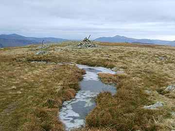
The highest point is marked by a large pile of stones, called a cairn, on a small rocky spot. The old fenceposts pass right by it!
Amazing Views from the Top
Because Ullscarf is so central, the views from the top are incredible! You can see far and wide, with the famous Scafells and Helvellyn mountain ranges looking especially impressive. It's a great spot to feel like you're on top of the world!
How to Climb Ullscarf
There are a few ways to climb Ullscarf, depending on where you start.
Routes from the South and East
If you start from Wythburn to the southeast, you can follow the Wythburn valley (watch out for boggy spots!) to reach the ridge at Greenup Edge. Or, you can take more direct paths up through Harrop Tarn. From there, you can aim for the tops above Nab Crags or Standing Crag.
Climbing from the North
You can also climb Ullscarf from Watendlath. This route takes you up the north-north-east ridge, passing above Blea Tarn, and then over the tops of Coldbarrow Fell.
The Popular Coast to Coast Route
One of the most popular ways to climb Ullscarf is by following the Greenup valley from Stonethwaite. This path is part of Wainwright's famous Coast to Coast Walk. You'll walk beside Lining Crag and then turn north before Greenup Edge to "cut the corner" and head towards the summit.
 | William Lucy |
 | Charles Hayes |
 | Cleveland Robinson |


