Arnison Crag facts for kids
Quick facts for kids Arnison Crag |
|
|---|---|

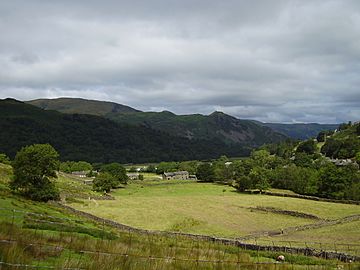
Arnison Crag (right of centre) from Hartsop
|
|
| Highest point | |
| Elevation | 433 m (1,421 ft) |
| Prominence | c. 10 m |
| Parent peak | Birks |
| Listing | Wainwright |
| Geography | |
| Location | Cumbria, England |
| Parent range | Lake District, Eastern Fells |
| OS grid | NY393150 |
| Topo map | OS Explorer OL5 |
Arnison Crag is a small but mighty fell (that's a local word for a hill or mountain) in the beautiful Lake District in England. It's part of a larger group of hills called the Fairfield group, found in the eastern part of the Lake District. This crag offers amazing views down to the charming village of Patterdale and the sparkling waters of Ullswater lake.
Contents
What is Arnison Crag?
Arnison Crag is officially a ridge that sticks out from a bigger fell called Birks. Even though it's connected to Birks, a famous guidebook writer named Alfred Wainwright decided to list Arnison Crag as its own separate fell in his popular Pictorial Guide to the Lakeland Fells. He called it "a low hill with a summit worthy of a mountain," which shows how special it is! Many people still follow his idea today.
Where is it located?
Birks is a fell that runs from the southwest to the northeast. Arnison Crag is like a side branch that comes off Birks. It goes eastward and then curves north. The rocky top of Arnison Crag is at the very end of this branch. The small dip where Arnison Crag connects to Birks is called Trough Head.
To the east of Arnison Crag, you'll find the lower part of Deepdale valley and a small area called Bridgend. This side of the fell is quite rugged, with rocky parts like Aiken Crag. To the west, a stream called Hag Beck separates Arnison Crag from the main Birks ridge. Hag Beck flows north from Trough Head. It goes through a wooded area called Glenamara Park before joining another stream, Grisedale Beck. Glenamara Park used to be a place where deer lived, and it still has many different kinds of trees. You can even see parts of its old stone wall!
The Summit Views
The very top of Arnison Crag is a small rocky peak. It looks really cool from the valleys around it. There isn't much loose stone here, so the small pile of stones (called a cairn) at the top is quite tiny. From the summit, you can see some of the higher fells, like the Fairfield group and the High Street fells. However, your view is mostly blocked by these taller mountains.
How to Climb Arnison Crag
You can start your climb to Arnison Crag from Patterdale village. There are a few ways to go:
- You can go straight up the front of the ridge.
- You can walk around to the west and follow the wall of Glenamara Park.
You can also reach Trough Head from Deepdale or Hag Beck. This way lets you approach the summit from "behind." Arnison Crag is often the first part of a longer hike to St Sunday Crag. From there, you can choose to explore the Deepdale valley by visiting fells like Fairfield, Hart Crag, and Hartsop above How. Or, you can head north around Grisedale, taking in peaks like Dollywaggon Pike, Nethermost Pike, and the famous Helvellyn.
Geology and Mining History
If you look closely at the slopes of Arnison Crag that face Deepdale, you might spot signs of old mining. In the past, people dug for a type of iron ore called haematite just above Deepdale Hall. The rock at the very top of Arnison Crag is a type of volcanic rock called andesite. On the northwestern side, you can see older rocks made from volcanic sand.
 | Selma Burke |
 | Pauline Powell Burns |
 | Frederick J. Brown |
 | Robert Blackburn |


