Lonscale Fell facts for kids
Quick facts for kids Lonscale Fell |
|
|---|---|

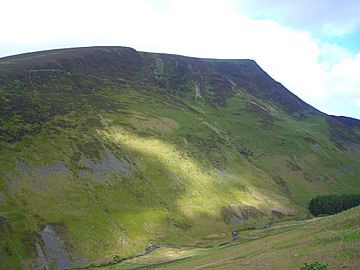
Seen from above the Glenderaterra valley on the path from Threlkeld.
|
|
| Highest point | |
| Elevation | 715 m (2,346 ft) |
| Prominence | c. 50 m |
| Parent peak | Skiddaw Little Man |
| Listing | Wainwright, Hewitt, Nuttal |
| Geography | |
| Location | Cumbria, England |
| Parent range | Lake District, Northern Fells |
| OS grid | NY285272 |
| Topo map | OS Landranger 89, 90 OS Explorer OL4 |

Lonscale Fell is a cool hill located in the Lake District in England. You can easily spot its pointy second top. It stands at the eastern edge of the huge Skiddaw mountain group.
It's quite easy to climb Lonscale Fell. You can start your adventure from Keswick or from Skiddaw House to the north. Even though it's mostly used for sheep grazing today, a long time ago, people did a lot of mining here. They dug beneath the long, rocky eastern side of the hill.
Contents
Exploring Lonscale Fell's Landscape
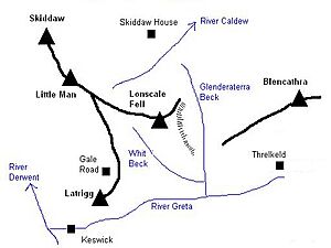
Lonscale Fell is the last big hill in a long line that comes down from Skiddaw. This line goes over smaller hills like Little Man and Jenkin Hill. After these, you reach a dip called Flag Pots. Then, Lonscale Fell rises up before dropping steeply down to the Glenderaterra Beck.
Southern Slopes and Valleys
The southern parts of Lonscale Fell gently slope down. They are covered in wide areas where sheep graze. This is typical for hills in the Skiddaw range. At the bottom of these slopes, you'll find the wooded valley of Whit Beck. This beck separates Lonscale Fell from the eastern ridge of Latrigg. The farm called Lonscale is also here, and it's where the fell gets its name.
Whit Beck flows into the Glenderaterra, a stream that forms the eastern edge of Lonscale Fell. The Glenderaterra flows south from Skiddaw Forest. It runs between the big Skiddaw mountains and Blencathra. Finally, it joins the River Greta and continues through Keswick. The eastern side of Lonscale Fell has a mile-long wall of steep rocks. This is a very unique feature in the Skiddaw area.
Northern Areas and Skiddaw Forest
To the north of Lonscale Fell, you'll find Skiddaw Forest. It's a bit confusing because this "forest" doesn't actually have any trees! The only trees are a small group around Skiddaw House, which helps block the wind. Skiddaw Forest is a marshy, high area about 1,300 feet up. It's surrounded by taller hills on all sides.
Three streams start in Skiddaw Forest. These streams divide the Northern Fells into three parts. Dash Beck flows to the northwest, the River Caldew flows to the northeast, and the River Glenderaterra flows south. The only building in Skiddaw Forest is Skiddaw House. It has been used as a shepherd's shelter and even a Youth Hostel in the past.
The northern border of Lonscale Fell is Salehow Beck. This beck is a small river that flows into the River Caldew. Its waters eventually reach the Solway Firth near Carlisle. Across the river is Great Calva, another one of the fells behind Skiddaw. The streams that feed Salehow Beck and Whit Beck both start from a low point called Flag Pots. This area completes the western boundary of Lonscale Fell.
Understanding Lonscale Fell's Rocks
Most of the Northern Fells, including Lonscale Fell, are made of a type of rock called the Kirk Stile Formation. This rock is part of the Skiddaw Group. It's made up of thin layers of mudstone and siltstone, along with a type of sandstone called greywacke. These rocks formed a very long time ago, during the Ordovician period.
Mining History in Glenderaterra Valley
The Glenderaterra valley was a busy place for mining in the 1800s. The mines in the northern part were first called Glenderaterra Mine. Later, they were known as Brundholme Mine. Miners mostly dug for lead here. They also looked for copper ore and a mineral called baryte. However, these mines never made much money. They were finally closed in 1920.
A little further south, there was another mine called Blencathra Mine. It was also not very successful and closed around 1880. You can still find some old, abandoned quarries below the eastern rocky cliffs of Lonscale Fell.
Reaching the Summit of Lonscale Fell
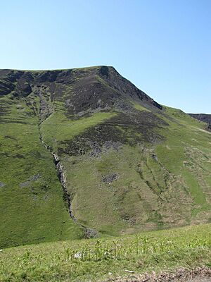
The very highest point of Lonscale Fell is on a gentle, rounded area on the western side of the hill. However, the pointy top that you can easily see from below is actually to the east. This eastern peak is about 2,306 feet high. Some guidebooks call this specific peak Lonscale Pike.
Interestingly, the line that divides the water flowing south to the River Greta and north to the River Caldew doesn't go over either of these tops. Instead, it follows the northeastern ridge of Burnt Horse. It goes over a spot that is 2,295 feet high and then continues towards Mungrisdale Common, which is a smaller hill connected to Blencathra.
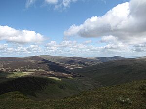
The highest point of Lonscale Fell has a small pile of stones called a cairn. From here, you get an amazing view of the Lake District to the south. You can see Thirlmere and Derwentwater lakes, along with all the major mountain groups. Looking in other directions, you'll see the northern fells up close, but the views are not quite as grand.
Climbing Lonscale Fell
There are several ways to climb Lonscale Fell. You can start from Keswick. Or, to make it a bit easier, you can begin from the Gale Road car park, which is behind Latrigg.
Routes from Keswick or Gale Road
- One way is to reach Flag Pots. You can get there by following the popular path that leads to Skiddaw.
- Another option is to take a direct route straight up the southern slopes of Lonscale Fell.
- You could also follow the southern edge of Lonscale Crags.
- The longest option is to walk all the way around the fell. You would go up the Glenderaterra valley and then approach the hill from behind.
Routes from Glenderaterra or Skiddaw House
If you are starting from the Glenderaterra valley or from Skiddaw House, you have a couple of choices to reach Lonscale Pike:
- You can use the Burnt Horse Ridge.
- Or, you can try a direct scramble up the rocky buttress.
 | Selma Burke |
 | Pauline Powell Burns |
 | Frederick J. Brown |
 | Robert Blackburn |


