
Latrigg facts for kids
Quick facts for kids Latrigg |
|
|---|---|

Latrigg as seen from Fitz Park in Keswick.
|
|
| Highest point | |
| Elevation | 368 m (1,207 ft) |
| Prominence | c. 70 m |
| Parent peak | Skiddaw |
| Listing | Wainwright |
| Geography | |

Latrigg
Location in Lake District
|
|
| Location | Cumbria, England |
| Parent range | Lake District, Northern Fells |
| OS grid | NY279247 |
| Topo map | OS Landrangers 89, 90, Explorer OL4 |
Latrigg is a small but very popular fell (a type of mountain) in the Lake District in North West England. Even though it's one of the lowest fells, many people love to climb it. This is because it's super easy to get to from the town of Keswick. Plus, it offers amazing views of the Borrowdale valley from its top!
Latrigg is part of the Skiddaw fells, but it's the least rocky of them all. Its slopes have some trees, and you might even spot a special lone tree near the top. This tree looks like a silhouette when you're driving towards Keswick. Did you know Latrigg also has petrified trees (trees that have turned into stone over time) on its summit?
Contents
Latrigg's Shape and Surroundings
Latrigg is the southernmost part of the big Skiddaw mountain area. It looks like a rounded hill at the end of a long ridge that slopes downwards. If it weren't for its awesome location, it might not stand out as much!
To the north of Latrigg's top, the land dips down before rising again towards Skiddaw Little Man. Latrigg also has a narrow ridge that stretches out to the east for about a mile.
Waterways Around Latrigg
Two streams flow down from the northern side of Latrigg. Gale Gill flows west and joins the River Derwent. This river flows between Derwentwater and Bassenthwaite Lake. Another stream to the east joins Whit Beck, which then flows into the River Greta. The River Greta also eventually meets the River Derwent near Keswick.
Slopes and Woodlands
The steep southern slopes of Latrigg are covered in a mix of trees, forming Brundholme Wood and Whinny Brow. Latrigg doesn't have many visible rocky cliffs, as the few it has are hidden within these trees. A public road from Keswick winds across this slope, giving access to local farms. More mixed woodlands have been planted on the northeastern slopes above Whit Beck. To the northwest, near Gale Gill, you'll find conifer forests. A single-track road goes up the slope next to these woods, leading to a car park near the top of the fell.

Latrigg's Rocks and History
Most of the rocks in the Northern Fells, including Latrigg, are from something called the Kirk Stile Formation. These rocks are made of layers of mudstone and siltstone, along with sandstone. They are very old, dating back to the Ordovician period. There are also two places on Latrigg's southern slopes where parts of the rock have slipped down.
The Summit of Latrigg
The very top of Latrigg is a grassy area where sheep graze. It slopes gently to the north but quite steeply to the south. You might see some tree stumps on the southern slope. These are left over from when trees were cut down a long time ago. There are also a few small trees that are bent over from the strong winds.
You'll also notice a ditch and a small wall (called a parapet) running across the top. The wall was once the base of a fence, and the ditch was dug to get the earth needed to build it.
Amazing Views from the Top
Looking north from the summit, you'll see the big, grassy sides of Skiddaw and Blencathra. They look impressive, but the real show is to the south! From there, you can look over Keswick and see the entire length of Derwentwater. Your eyes will be drawn to the beautiful Borrowdale valley and the tall fells of Central Lakeland.
Alfred Wainwright, a famous fell-walker, once said that this view was "a panorama of crowded detail, all of it of great beauty." He even called it "one of the gems of the district." He described the distant horizon as "a jumbled upheaval of peaks, with many dear old friends standing up proudly."
You can see a computer-generated panorama of the summit view here.
Right on top of the summit, there's a special tree known as The Witch. It got this name because its shape looks like a person riding a broomstick!
How to Climb Latrigg
Many people start their climb of Latrigg from Keswick. You can begin on Spooney Green Lane, near the old railway station. From there, you can either head straight for the top or go north first.
Another starting point is the village of Threlkeld. From there, you'd cross Glenderaterra Beck and then climb up the east ridge.
The easiest way to reach the summit is to drive to the end of Gale Road. From the car park there, it's just a simple 10-minute walk on grass to the top! This makes Latrigg the most accessible of all 214 Wainwrights (the fells described by Alfred Wainwright). This car park is also often used by people starting their climb up Skiddaw. However, some serious hikers prefer to climb Latrigg from Keswick first before heading up Skiddaw.
Good news! A new path has been built that allows people with disabilities to access the summit of Latrigg from the car park.
Gallery
-
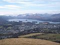
Keswick and Derwent Water seen from Latrigg summit.
-
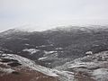
Skiddaw in the fog from Latrigg.
-
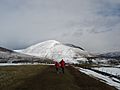
Blencathra from Latrigg


