Ling Fell facts for kids
Quick facts for kids Ling Fell |
|
|---|---|

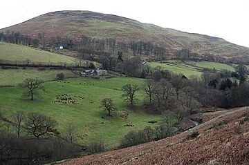
Ling Fell from the slopes of Sale Fell
|
|
| Highest point | |
| Elevation | 373 m (1,224 ft) |
| Prominence | c. 97 m |
| Parent peak | Lord's Seat |
| Listing | Wainwright |
| Geography | |
| Location | Cumbria, England |
| Parent range | Lake District, North Western Fells |
| OS grid | NY179286 |
| Topo map | OS Landranger 89, 90, Explorer OL4 |
Ling Fell is a small hill located in the northwest part of the Lake District in the United Kingdom. It's very close to the village of Wythop Mill, making it an easy place to climb.
Ling Fell looks like a wide, rounded dome. It's a safe and easy climb with no tricky parts. Its name comes from the plant 'ling', which is another name for heather. This plant covers most of the hill! From the top, you get great views of the town of Cockermouth.
Contents
Where is Ling Fell Located?
Ling Fell is part of the North Western Fells. These are hills found between the Derwent and Cocker rivers. They form a long, oval-shaped area.
Two main roads cut across these hills, splitting them into three groups. Ling Fell is in the northern part, between Whinlatter Pass and the Embleton Valley.
Ling Fell and its nearby twin, Sale Fell, are the last hills in this area that feel like the Lake District. If you go further north, the hills become much smaller.
The famous guidebook writer Alfred Wainwright wrote about Ling Fell in his book, Pictorial Guide to the Lakeland Fells. He described it as a "rounded hill" that looks a bit "gloomy and sulky" because of its dark heather covering.
To the south of Ling Fell is a wet, marshy area called Wythop Moss. Beyond this, there's a line of higher hills: Lord's Seat, Broom Fell, and Graystones. Water from Wythop Moss slowly drains around the west side of Ling Fell through a stream called Tom Rudd Beck.
Even though Ling Fell and Sale Fell stand side by side, they are not directly connected. Ling Fell is linked to Broom Fell, while Sale Fell is part of Lord's Seat. A stream called Wythop Beck separates them. These two fells act like gateways to this quiet valley as it goes down into the Embleton Valley.
Ling Fell does not have any forests. You can still see the remains of old grouse butts, which show that people used to hunt birds here.
What is Ling Fell Made Of?
The main part of Ling Fell is made mostly of rocks from the Ordovician period. These rocks are called the Loweswater Formation. They are made of greywacke sandstone layers. The southern parts of the hill are made of thin layers of mudstone and siltstone from the Kirk Stile Formation. There's also a small area of dolerite rock on the northern side.
Reaching the Summit
The very top of Ling Fell is smooth and rounded. The highest point is marked by an Ordnance Survey triangulation column. This is a special pillar used for mapping.
When you are at the top, views to the south are blocked by the taller Broom Fell. However, you can clearly see the Skiddaw and Grasmoor fells. The best views are to the north, where you can see the Solway Firth and the hills of Galloway in Scotland.
How to Climb Ling Fell
The village of Wythop Mill is very close to the north of Ling Fell. From the village, you can follow a road that goes up the narrow, wooded valley between Ling Fell and Sale Fell.
After about half a mile, you'll find a good path that turns right onto the slopes of Ling Fell. This path goes around the northern side of the hill. From there, you can take a direct route straight to the summit.
 | Valerie Thomas |
 | Frederick McKinley Jones |
 | George Edward Alcorn Jr. |
 | Thomas Mensah |


