
Graystones facts for kids
Quick facts for kids Graystones |
|
|---|---|

Seen from the Whinlatter Pass road at Spout Force car park.
|
|
| Highest point | |
| Elevation | 456 m (1,496 ft) |
| Prominence | c. 80 m |
| Listing | Wainwright |
| Geography | |

Graystones
Location in Lake District
|
|
| Location | Cumbria, England |
| Parent range | Lake District, North Western Fells |
| OS grid | NY177266 |
| Topo map | OS Landranger 89, 90, Explorer OL4 |

Graystones is a fell (a type of mountain or hill) located in the beautiful Lake District in England. It's part of the North Western Fells area. This fell is one of the peaks that form a ridge, which is like a long line of hills, around the valley of Aiken Beck.
Contents
What's in a Name?
The name Graystones can be a bit confusing! According to a famous author named Alfred Wainwright, the name Graystones really only means the very top part of the hill. However, in his popular guidebooks, Pictorial Guide to the Lakeland Fells, he decided to use Graystones to refer to the whole fell.
Wainwright also said that the hill's proper name is actually Kirk Fell. But don't mix it up with another, much bigger Kirk Fell in Wasdale! Some other guidebooks think that Graystones is the eastern (east-facing) top, and Kirk Fell is the western (west-facing) top. Maps from the Ordnance Survey also show these names in a way that supports this idea.
Exploring Graystones: The Landscape
The North Western Fells are a hilly area between two rivers, the Derwent and the Cocker. Imagine an oval shape of hills stretching from north to south. Two main roads cut across this area, dividing the fells into three groups. Graystones is in the most northern group, rising between Whinlatter Pass and the Embleton valley.
The highest parts of this northern area are on a ridge. This ridge goes from the Lorton valley in the west to the shore of Bassenthwaite Lake in the east. Along this ridge, you'll find Graystones, Broom Fell, Lord's Seat, and Barf. Another hill called Whinlatter is nearby to the south.
Gentle, grassy slopes lead up from the wide Lorton valley to the western top, which some call Kirk Fell. A little further east, after a small dip, you'll reach the Graystones summit. The ridge then gets narrower as it crosses a long, flat area called Widow Hause, before continuing towards Broom Fell.
To the south of Graystones, you'll find Blaze Beck and Aiken Beck, which are small streams. Another stream, Sware Gill, flows down from the low point (or col) between Kirk Fell and Graystones. The southern slopes of Graystones and the entire southern side of Widow Hause are covered with evergreen trees in the Darling How Plantation. Deep inside these woods, you can find Spout Force, a beautiful waterfall on Aiken Beck.
The northern slopes of Graystones gently go down towards Embleton High Common and a large, marshy area called Wythop Moss. To the northwest, there's a hill called Harrot (958 feet high), which offers great views of Lorton and Cockermouth.
What's Underneath: Geology
The main type of rock you'll find at Graystones is called the Kirkstile Formation. This rock is made of thin layers of siltstone and mudstone. On the southern slopes, there's also evidence of greywacke sandstone. You might also spot small amounts of a rock called lamprophyre.
Reaching the Top: The Summit
The very top of Graystones is grassy. The highest point is marked by a slight rise in the rock itself. It's just a few yards from the end of a wall that comes up from Widow Hause. There's also a cairn (a pile of stones) built on the western slopes of Kirk Fell.
Because the slopes are quite gentle, the view from the top isn't dramatic, but it's still lovely! You can see the Loweswater Fells and the hills around Coledale Hause. On a clear day, you might even catch glimpses of Skiddaw and Helvellyn. You can also see a wide view of the Scottish coast in the distance.
Ways to Climb Graystones
There are a few ways to climb Graystones:
- From the northwest, starting at Armaside, you can go via Harrot and Kirk Fell.
- From the north, you can follow Tom Rudd Beck from Embleton.
- The quickest way is from Scawgill Bridge, which is on the Whinlatter Pass road. From there, you can follow the remains of old walls and fences straight to the summit.
Images for kids
-
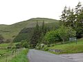
Seen from the Whinlatter Pass road at Spout Force car park.
-
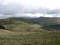
The view NE from the summit takes in the adjoining fells of Broom Fell (left) and Lord's Seat (right).
