Stony Cove Pike facts for kids
Quick facts for kids Stony Cove Pike |
|
|---|---|

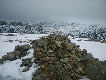
Cairn on Stony Cove Pike
|
|
| Highest point | |
| Elevation | 763 m (2,503 ft) |
| Prominence | 171 m (561 ft) |
| Parent peak | High Street |
| Listing | Marilyn, Hewitt, Wainwright, Nuttall |
| Geography | |
| Location | Cumbria, England |
| Parent range | Lake District, Far Eastern Fells |
| OS grid | NY417100 |
| Topo map | OS Explorer OL5, Explorer OL7 |
Stony Cove Pike is a mountain, also called a fell, located in the eastern part of the Lake District in England. It is also known by the names Caudale Moor or John Bell's Banner.
This fell stands across the Kirkstone Pass from another mountain called Red Screes. It is part of a ridge that stretches down from High Street. Stony Cove Pike is special because it's separated from nearby mountains by a deep dip in the land called Threshthwaite Mouth. This makes it a "Marilyn," which is a hill with a height difference of at least 150 meters from the land around it. It is the sixteenth highest Marilyn in the Lake District.
What's in a Name?
The names for Stony Cove Pike can be a bit confusing! Different maps and guidebooks use the names in different ways.
For example, the official Ordnance Survey maps call the main top 'Stony Cove Pike'. They use 'Caudale Moor' for a second, slightly lower top to the west. The name 'John Bell's Banner' is used for a ridge that goes down towards St Raven's Edge.
However, Alfred Wainwright, a famous writer about the Lake District, used 'Caudale Moor' for the whole mountain. He saw 'John Bell's Banner' as another name for the whole fell and 'Stony Cove Pike' just for the main peak. Another writer, Bill Birkett, mostly agrees with the Ordnance Survey maps. He also uses 'John Bell's Banner' as a second name for the lower western top.
The Mountain's Shape
Stony Cove Pike is a wide and spread-out mountain. It has six different ridges that stretch out from its top area. The main summit has four ridges pointing in different directions.
To the east, the land drops steeply down to Threshthwaite Mouth. From there, it climbs steeply up to Thornthwaite Crag. To the north, a grassy ridge leads to Hartsop Dodd. To the west, the flat top narrows a little towards the second peak, which is called Caudale Moor or John Bell's Banner. South of the main top, a short ridge sticks out into the Trout Beck valley before dropping sharply over Doup Crag.
From the lower Caudale Moor top, a narrow ridge called Rough Edge goes down northwest towards Caudale Bridge. About halfway down this ridge, you can find the large Caudale Quarry. This was a place where rocks were dug out, and it used to have a very steep path for workers. There are also signs that people dug even deeper here for minerals.
Another wide ridge goes south from the Caudale Moor top. This ridge goes over Pike How before splitting into two parts around the start of Woundale. One part goes southwest down St Raven's Edge to the Kirkstone Pass road. From there, it climbs up again to Wansfell. The other part, which is shorter, drops over Hart Crag and Great Knott into the Troutbeck valley.
The Top of the Mountain
The very top of Stony Cove Pike is mostly covered in grass. You can find several small mountain lakes, called tarns, between its two main peaks. Stone walls follow the ridges, which helps people find their way when hiking.
Both the main top and the lower Caudale Moor top have cairns, which are piles of stones. There's also another cairn with a wooden cross to the southwest of Caudale Moor. This is known as Mark Atkinson's monument.
Even though the very top can seem a bit plain, there are many rocky cliffs around the edges of the flat area. For example, Caudale Head, between the northern ridges, has cliffs. More cliffs are found north and south of Threshthwaite Mouth. Because the top is quite flat, the views of other mountains might seem a bit limited. However, you can still see all the major mountain groups from the summit.
How to Climb It
One popular way to climb Stony Cove Pike is to make a circular walk from the Patterdale valley. You go up the steep north ridge to the top, then cross Threshthwaite Mouth, and climb up to Thornthwaite Crag. From Thornthwaite Crag, you complete the circle by going down its north ridge, which is known as Gray Crag.
Another longer way to climb the mountain is from the southern ridge, starting from Wansfell and Ambleside. The fastest way to reach the top is from the top of Kirkstone Pass, by following St Raven's Edge. However, Alfred Wainwright once said this was the "dullest way up" the mountain!
 | William M. Jackson |
 | Juan E. Gilbert |
 | Neil deGrasse Tyson |


