Wether Hill (Lake District) facts for kids
Quick facts for kids Wether Hill |
|
|---|---|

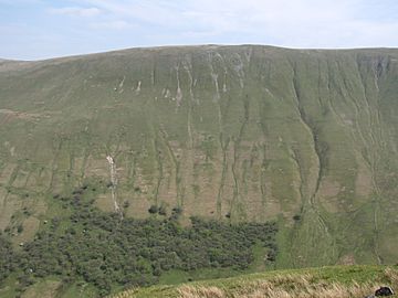
Seen from The Nab, 2.5 km to the SW. Wether Hill's western slopes drop steeply into Martindale.
|
|
| Highest point | |
| Elevation | 674 m (2,211 ft) |
| Prominence | < 20 m |
| Parent peak | High Raise |
| Listing | Wainwright, Nuttall |
| Geography | |
| Location | Cumbria, England |
| Parent range | Lake District, Far Eastern Fells |
| OS grid | NY456167 |
| Topo map | OS Explorer OL5 |
Wether Hill is a cool hill, or "fell," found in the amazing English Lake District. It sits right between two places called Martindale and Haweswater. Imagine a long line of hills running north to south – Wether Hill is on that line, between Loadpot Hill and High Raise. It also has smaller ridges spreading out like arms to the east and northwest.
Contents
Exploring Wether Hill's Landscape
Wether Hill is part of the Far Eastern Fells in the Lake District. It has different sides that look out over various valleys and lakes.
What's North of Wether Hill?
To the north of Wether Hill, you'll find Loadpot Hill, which is almost the same height. Water flows from this area, creating streams that eventually reach a village called Bampton.
The Eastern Side of Wether Hill
Wether Hill has a long eastern ridge that stretches for about three miles. This ridge goes over a place called Bampton Fell. Along this ridge, you can find some rocky tops above the northern shore of Haweswater. One interesting spot is Four Stones Hill, which has ancient standing stones!
The Southern Side of Wether Hill
South of Wether Hill, the main ridge gets narrower before climbing up to Red Crag. Streams flow east from here, forming Measand Beck. This beck runs below Low Kop and Bampton Fell, entering Haweswater. Before the lake was made bigger, this area was farmed, but now it's underwater.
The Western Side of Wether Hill
The western side of Wether Hill drops steeply into Rampsgill, which is part of the Martindale valley. You can see some trees planted at the bottom. Partway down this slope is a round, grassy hill called Gowk Hill. From here, a rocky path goes north over Brownthwaite Crag and Steel Knotts. Between this area and Loadpot Hill is a small valley called Fusedale.
Reaching the Top of Wether Hill
The top of Wether Hill is covered in grass and has two high points that are very similar in height. The northern top has a pile of stones, called a cairn, and is usually thought of as the main summit.
A very old Roman road (called High Street) runs along the north-south ridge. It just misses both of Wether Hill's tops. From the summit, you can get amazing views! You can look west towards the Helvellyn mountain range and see a wide view of the Pennines in the opposite direction.
How to Climb Wether Hill
There are a few ways to climb Wether Hill:
- From Martindale, you can walk up via Steel Knotts or Fusedale.
- From Haweswater (near Burnbanks), you can approach by following Measand Beck or using the eastern ridge.
- You can also reach the eastern ridge from Bampton via a path called The Hause.
- Many people also climb Wether Hill as they walk along the Roman road, going from High Raise to Loadpot Hill.
 | Charles R. Drew |
 | Benjamin Banneker |
 | Jane C. Wright |
 | Roger Arliner Young |


