Carl Side facts for kids
Quick facts for kids Carl Side |
|
|---|---|

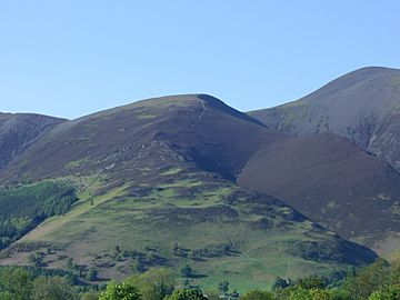
Carl Side from the village of Portinscale with Skiddaw rising on the right
|
|
| Highest point | |
| Elevation | 746 m (2,448 ft) |
| Prominence | c. 30 m |
| Parent peak | Skiddaw |
| Listing | Hewitt, Nuttall, Wainwright |
| Geography | |
| Location | Cumbria, England |
| Parent range | Lake District, Northern Fells |
| OS grid | NY255280 |
| Topo map | OS Landrangers 89, 90, Explorer OL4 |
Carl Side is a mountain, or fell, in the beautiful Lake District in England. It is part of the larger Skiddaw mountain group. You can easily see Carl Side from the nearby town of Keswick.
This fell is special because it is listed in Alfred Wainwright's famous Pictorial Guides to the Lakeland Fells. These books describe all the main fells in the Lake District. Carl Side is one of the Northern Fells in these guides.
Contents
Exploring Carl Side
Carl Side is a great place to explore. It offers amazing views and interesting features.
The Summit of Carl Side
The very top of Carl Side is mostly a grassy area. It slopes gently downwards on most sides. However, to the north, you can see some broken rocks looking down into a valley called Southerndale.
A small pile of stones, called a cairn, marks the highest point. From the top, you get a fantastic view looking south over Derwentwater. You can also see many other fells stretching from Clough Head to Sale Fell.
How Carl Side is Shaped
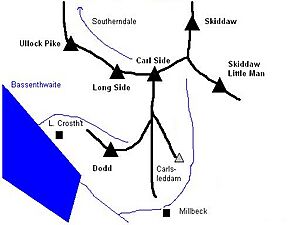
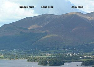
Carl Side is part of a long ridge called Longside Edge. This ridge starts from the top of Skiddaw and curves around. It then goes down through three fells: Carl Side, Long Side, and Ullock Pike.
Carl Side is at the southern end of this curving ridge. It has a triangular shape with ridges going in three directions.
Carlside Col and Tarn
To the north-east, Carl Side is separated from Skiddaw by a dip in the land called Carlside Col. This col is about 715 meters (2,345 feet) high.
In this dip, you'll find Carlside Tarn. A tarn is a small mountain lake. This is the only lake found high up in the Skiddaw mountain group. The tarn is quite shallow and often dries up in summer. It doesn't have any plants growing in it.
Ridges and Valleys
From the top of Carl Side, several ridges go south towards a place called Millbeck. The main ridge goes straight for about a mile. Part of it has a gentle slope, ending in a patch of white stones. There's also a short, rocky section called an arête here. An arête is a sharp, narrow ridge.
On the western side of this area, across a rocky dip called Long Doors, is Dodd. Dodd is a fell mostly covered in trees managed by the Forestry Commission.
The north-western ridge connects Carl Side to Long Side. This ridge is narrower and has rough ground to the north. All the water from Carl Side, like Southerndale Beck, eventually flows into Bassenthwaite Lake.
Carl Side's Rocks
The rocks that make up Carl Side are mostly from the Kirk Stile Formation. These rocks are part of the Skiddaw Group. They are made of layers of mudstone and siltstone, with some greywacke sandstone. These rocks formed a very long time ago, during the Ordovician period.
You can also find an old mining tunnel in the small valley between Carlsleddam and the south ridge. This tunnel was used in the 1870s to dig for minerals like baryte and galena.
Climbing Carl Side
Many people enjoy climbing Carl Side. It's often climbed as part of a longer walk.
Popular Routes
One popular way to climb Carl Side is to start by climbing Ullock Pike and Long Side first. The narrow ridge connecting these fells makes for a great walk. Many hikers then continue their journey to the top of Skiddaw.
You can also start your climb from Millbeck. There are different paths you can take from there. Another option is to start from Little Crosthwaite, a small village near Dodd. From there, you can walk through the forest to Long Doors and then join the south ridge.
If you start from High Side near Bassenthwaite, you can walk along Southerndale valley. This path eventually leads you up to Carlside Col.
 | DeHart Hubbard |
 | Wilma Rudolph |
 | Jesse Owens |
 | Jackie Joyner-Kersee |
 | Major Taylor |


