
The Cheviot facts for kids
Quick facts for kids The Cheviot |
|
|---|---|

The Cheviot in snow
|
|
| Highest point | |
| Elevation | 815 m (2,674 ft) |
| Prominence | 556 m (1,824 ft) |
| Parent peak | Broad Law |
| Listing | Marilyn, Hewitt, County Top, Nuttall |
| Naming | |
| English translation | Having the quality of a ridge |
| Language of name | Common Brittonic |
| Geography | |

The Cheviot
Location in Northumberland
|
|
| Location | Cheviot Hills, England |
| OS grid | NT909205 |
| Topo map | OS Landranger 74/75 |
| Geology | |
| Mountain type | Stratovolcano (extinct) |
The Cheviot is the tallest mountain in the Cheviot Hills. It is located in the very north of England, close to the Scottish border, about 2 kilometers (1.25 miles) away. This mountain is an extinct volcano from a very old time called the Caledonian period. If you are hiking the famous Pennine Way trail from south to north, The Cheviot is the last big mountain you will climb before reaching Kirk Yetholm.
Contents
What Does "Cheviot" Mean?
The name Cheviot was first written down in 1181 as Chiuiet. It likely comes from an old language called Brittonic. The name probably means "a ridge" or "having the quality of a ridge."
How The Cheviot Was Formed
The Cheviot is an extinct stratovolcano. This means it was once a very active volcano that erupted a long, long time ago. Its eruptions happened during the Caledonian orogeny, a period of mountain building between 490 and 390 million years ago.
The mountain you see today is much smaller than it used to be. It has been worn down by weather and time. Scientists think it might have once been as tall as 3,000 meters (10,000 feet)! Its base might have spread out for about 60 kilometers (37 miles).
The earliest eruptions in this area were very powerful and explosive. They sent out ash and hot gas flows, known as pyroclastic flows, as far as Coquetdale and Ingram. Later, the volcano produced different types of lava, like andesitic, trachyte, and rhyolitic lava. This lava covered a huge area, about 600 square kilometers (230 square miles).
The very top of The Cheviot is quite flat. It is covered with a thick layer of peat bog, which can be up to 2 meters (6 feet) deep. To protect this peat and make it safer for hikers, the Northumberland National Park Authority has placed stone slabs on the main walking path.
The Cheviot's Past
People have lived around The Cheviot for a very long time. Near Hethpool, experts have found the remains of an ancient neolithic henge monument. This stone circle might be from around 2500 BC. Some people believe it was a special entrance or gateway to the mountain for ancient rituals.
Harthope Burn is a stream that flows through a deep valley on the side of The Cheviot. In the 1500s and 1600s, this valley marked the border between different groups of Border reivers, who were raiders from England and Scotland.

During World War II, The Cheviot and the nearby hills were the scene of several aircraft crashes. These accidents sadly took the lives of both Allied and German airmen. A local shepherd named John Dagg and his sheepdog bravely rescued a pilot after an RAF crash in 1942. Dagg also helped survivors of another crash in December 1944, which killed two members of a nine-person US Air Force crew. Even today, you can still find pieces of aircraft wreckage on the mountain.
How to Reach The Cheviot
Most people start their climb up The Cheviot from the Harthope Burn side, which is to the northeast. This area offers the closest road access. The summit is about 5 kilometers (3 miles) from the end of the road at Langleeford. Across the valley to the east, you can see the rounded top of Hedgehope Hill.
There are different paths you can take. Some follow the ridges on either side of the valley. Another path stays in the valley floor for a while before climbing up to the summit.
The famous Pennine Way hiking trail passes near The Cheviot. However, the trail itself makes a 3-kilometer (2-mile) detour to reach the very top. Many hikers on this long, 47-kilometer (29-mile) section of the Pennine Way choose to skip the detour to the summit.


What You Can See From The Top
The view from the summit of The Cheviot is a bit blocked because the top is very flat. However, on a clear day, you can still see many other hills and mountains. Looking around from west to east, you might spot Broad Law, the Moorfoot Hills, Pentland Hills, the Ochil Hills, Lammermuir Hills, Ros Hill, Long Crag, Urra Moor, Tosson Hill, Burnhope Seat, Cross Fell, Helvellyn, Scafell Pike, Skiddaw, Sighty Crag, Peel Fell, and Queensberry.
Images for kids
-
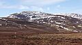
The Cheviot in snow
-
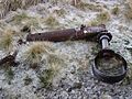
The landing gear of a B-17 bomber that crashed in World War II
-
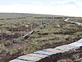
The Pennine Way approaching the summit of The Cheviot
-
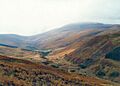
The Cheviot and Harthope Valley
