
River Coquet facts for kids
Quick facts for kids River Coquet |
|
|---|---|

River Coquet near Rothbury
|
|
| Country | United Kingdom |
| County | Northumberland |
| Physical characteristics | |
| Main source | 55°21′45″N 2°21′17″W / 55.3625°N 2.3548°W |
| River mouth | Amble 55°20′21″N 1°34′18″W / 55.3393°N 1.5718°W |
| Length | 90 km (56 mi) |
| Basin features | |
| Basin size | 625 km2 (241 sq mi) |
The River Coquet is a beautiful river in Northumberland, England. It flows into the North Sea at Amble on the east coast. The river starts high up in the Cheviot Hills, right on the border between England and Scotland. It then winds its way through the landscape, creating a valley known as "Coquetdale."
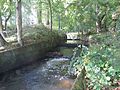
Along its journey, the River Coquet passes through many small villages. It also flows into a lake at the Caistron Nature Reserve. This lake was made when people dug for gravel. The river then reaches the town of Rothbury, where an old bridge crosses it. Further downstream, you can find Thrum Mill, a historic building that was restored on a TV show.
The river also flows past Brinkburn Priory, an old religious building from the 1130s. At Felton, two bridges cross the river. One is very old, from the 1400s, and the other was built in 1927. Near Brainshaugh, the river flows over a large horseshoe-shaped dam. This dam was built in 1775 by an engineer named John Smeaton. It once powered factories. Before reaching Warkworth, the river goes over another dam. This dam helps supply drinking water to thousands of people.
Near Warkworth, the river becomes tidal, meaning its water levels change with the sea. Warkworth Castle is built inside a loop of the Coquet. The river finally meets the sea at Warkworth Harbour in Amble. Here, you'll find a Royal National Lifeboat Institution station, ready to help people at sea.
Contents
Journey of the River Coquet
The River Coquet is about 56 miles (90 km) (90 km) long. It begins in the Cheviot Hills at an elevation of about 1,440-foot (440 m). The border between England and Scotland follows the river for a short distance. You can still see the remains of Roman camps and a medieval village near Chew Green.
The river flows northeast, joined by smaller streams like Fulhope Burn and Blind Burn. It then turns east, meeting Carlcroft Burn and Hepden Burn. After passing between two hills, Barrow Law and Tindale Law, it turns south. The area south of the river is part of the Otterburn Training Area. This is a military training ground, so public access is limited.
More streams, like Deerbush Burn and Usway Burn, join the Coquet as it flows southeast. At Linbriggs, the Ridlees Burn adds to its waters, and the river turns east. In the village of Alwinton, three more rivers, Barrow Burn, Hosedon Burn, and River Alwin, all meet the Coquet. The river then continues southeast through Harbottle. This area has ancient sites, including a Neolithic enclosure and Bronze Age burial mounds.
Bridges and Ancient Sites
Many bridges cross the upper part of the Coquet, especially above Alwinton. Before 1928, people mostly used shallow crossings called fords. Linbriggs Bridge was one of the first new bridges, built with a concrete arch over a 70-foot (21 m) gorge. Other bridges were built with flat decks, and the program finished in 1968. Old maps from 1897 show three suspension bridges for walkers.
The Holystone Burn joins the Coquet at Holystone. This village has a "Holy Well" with a stone tank from Roman times. It was once thought that Bishop Paulinus baptized many people here in 627 AD. The well is a very important historic structure. A Roman road also passed through the well area and crossed the Coquet.
Near Hepple, there was once an iron suspension bridge. By the time the river reaches Hepple bridge, it has dropped below 330-foot (100 m) in elevation. The river then turns northeast and flows past Caistron. Here, there are two large lakes created by digging for sand and gravel, which started in 1956. The biggest lake is 50 acres (20 ha) and is a nature reserve and fishing spot.
Middle Section of the River
The river flows south of Thropton, where Wreigh Burn joins it. It then goes through Rothbury, where a bridge from the 1500s crosses the river. This bridge was originally for packhorses but was made wider over time for vehicles. It is now a protected historic site. Downstream from Rothbury is Thrum Mill, an old three-story mill building from the 1700s and 1800s. Its restoration was shown on the TV program The Restoration Man.
The river continues through Pauperhaugh, where there is another bridge and a small waterfall (weir). It then loops around a piece of land that was given to a group of monks called Augustinian canons in the 1130s. They built Brinkburn Priory here. After many years, the main building was fixed up in 1858 and used as a church. Today, both the church and a nearby manor house are managed by English Heritage and are open to visitors. Brinkburn Mill, built in the 1700s, is also nearby.
After Weldon, the Coquet is crossed by the A1 road. As it nears Felton, there is a dam that once fed Felton corn mill. This mill was used until 1970 and has since been turned into homes. At Felton, the river turns northeast and is crossed by two bridges. One is from the 1400s, and the other is a newer concrete bridge built in 1927. A new sewage treatment plant was built here in the 1990s to clean water before it goes back into the river.
Near Brainshaugh, the river flows over a horseshoe-shaped dam. This dam was built in 1775 by John Smeaton. It originally powered an iron and tin factory. Later, it became a wool mill and then one of the first factories in the country to use hydroelectric power. The factory closed in 1930 because it was polluting the river.
Lower River and the Sea
Further downstream near Guyzance are the ruins of Brainshaugh Priory, an old nunnery. Another large dam here supplied water to Guyzance Mill. The East Coast Main Line railway crosses the river on a large viaduct with nine arches, built in 1849 or 1850.
Just west of Warkworth, the river flows over a large weir, and after this point, the water becomes tidal. On the south bank is Warkworth Water Treatment Works. This plant takes millions of liters of water from the river each day. It provides clean drinking water to 92,000 homes in nearby towns like Alnwick and Morpeth.
On the north bank, below the weir, is a cave hermitage. This is a very old cave dwelling from the 1300s and 1400s. It is one of the best-preserved sites of its kind in Britain. In the tidal section, the river loops around the center of Warkworth, where you can see its medieval castle and church.
Below Warkworth is the Amble half-tide weir. This weir helps keep water levels steady in Warkworth when the tide is low. It has a special "fish pass" to help fish move upstream. In 2018, changes were made to the weir to help fish avoid seals that were catching them.
The channel then widens to form Warkworth Harbour, with the town of Amble on the south bank. There is a marina and a Royal National Lifeboat Institution station with two lifeboats. The brave crew members have received many awards for their rescues. Finally, the River Coquet flows into the North Sea, almost directly across from Coquet Island, which is about 1 mile (1.6 km) out to sea.
River Mills and Their History
For a long time, people used the River Coquet to power mills. These mills used water wheels to do work. Most mills ground corn into flour, but some were used for "fulling" wool. Fulling was a process to clean and thicken wool fabric. Before mills, people would stomp on the cloth in tubs with their feet! Mills used mallets to beat the cloth, making the process much faster.
The earliest records of mills on the Coquet are from the 1100s. Many mills were owned by important landowners or religious groups. One of the oldest known fulling mills was on Hepden Burn, a small stream that flows into the Coquet. Archaeologists studied this site between 2010 and 2013. They found parts of a water wheel that was much older than expected, showing that this type of wheel was used earlier than previously thought.
Because the area was sometimes unsafe due to attacks from Scotland in the 1300s, some mills might not have been used for long. However, these old sites give us a rare look into how medieval mills worked.
There were also mills in other places along the river. For example, there were two mills at Alwinton in 1623. Holystone had two mills, including a corn mill. At Tosson, there was a corn mill and a fulling mill.
Rothbury had four mills at different times. Thrum Mill, which you can still see today, was a corn mill. Brinkburn Mill, owned by Brinkburn Priory, was mainly for grinding corn. Wheldon Mill was another corn mill. At Felton, there was a mill that operated until 1970.
Further downstream, Smeaton's dam at Guyzance powered an iron and tin factory, which later became a wool mill. Guyzance Mill was a corn mill. Morwick Mill, near Warkworth, was also a corn mill. One of the earliest mills on the river was Warkworth Mill. Its rent was used to provide light for a shrine in 1214! This mill was damaged by fire in 1860 and probably wasn't used after that.
River Coquet's Name and Water Quality
The River Coquet has a very old name. The earliest known mention is from the 700s, where it was called Coccuueda. Another old text from Bede called it Cocuedi fluminis. These names might mean 'Red River'. This could be because of the red pebbles found in the river.
The Environment Agency checks the water quality of rivers in England. They give each river an "ecological status" (how healthy the living things in it are) and a "chemical status" (how clean the water is from chemicals). These statuses can be high, good, moderate, poor, or bad.
Most of the River Coquet has good water quality. This means it's healthy for plants, insects, and fish. However, the very last part of the river, where it meets the sea, has "moderate" water quality. This is mainly because of changes made to the river channel and some runoff from farms, which can add extra nutrients to the water.
Images for kids
-
Warkworth fish pass was refurbished in 2013 after 20 years of dereliction
-
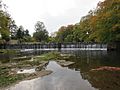
John Smeaton's weir at Guynance fed an iron and tin works when first built.
-

The estuary of the River Coquet in Amble


