Sighty Crag facts for kids
Quick facts for kids Sighty Crag |
|
|---|---|

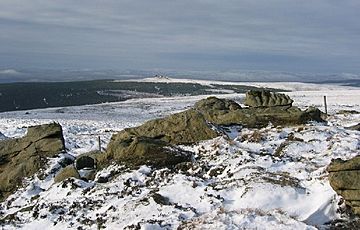
The summit of Sighty Crag
|
|
| Highest point | |
| Elevation | 518 m (1,699 ft) |
| Prominence | c. 295 m (968 ft) |
| Parent peak | The Cheviot |
| Listing | Marilyn |
| Geography | |
| Location | Kielder Forest, England |
| OS grid | NY601809 |
| Topo map | OS Landranger 80 |
Sighty Crag is a hill located in the southern part of the Kielder Forest area in northern England. This region is also home to other well-known hills called Marilyns, such as Peel Fell and Larriston Fells. Sighty Crag is separated from Peel Fell, which is taller and has a more distinct shape, by a low valley where the village of Kielder is found.
Contents
What is Sighty Crag?
Sighty Crag is a hill that stands 518 meters (about 1,700 feet) tall. It is known as a Marilyn, which is a special term for a hill in the British Isles that rises at least 150 meters (about 492 feet) above the land around it.
Where is Sighty Crag Located?
This hill is in a very quiet and remote part of northern Cumbria. However, the border with Northumberland runs just 600 meters (about 660 yards) north of the summit.
How Remote is Sighty Crag?
Sighty Crag is quite far from towns and roads. It is about four miles (6.5 kilometers) from the nearest road. This means that if you want to walk to the top and back, your journey would be at least eight miles (13 kilometers) long. Even though it's not the tallest hill, Sighty Crag is considered the most remote Marilyn in all of England when you think about how far it is from any towns or cities.
The Summit of Sighty Crag
The very top of Sighty Crag is marked by a rock formation. This outcrop is made of a type of rock called fell sandstone, and it has been shaped by the wind over many years.
 | Victor J. Glover |
 | Yvonne Cagle |
 | Jeanette Epps |
 | Bernard A. Harris Jr. |

