
Northumberland National Park facts for kids
Quick facts for kids Northumberland National Park |
|
|---|---|
|
IUCN Category V (Protected Landscape/Seascape)
|
|

View of Hadrian's Wall, Northumberland National Park
|
|
| Location | United Kingdom (North East England) |
Northumberland National Park is a special natural area in England. It is the most northern national park in the country. This park covers a huge area of over 1,050 square kilometres (410 sq mi). It stretches from the border with Scotland in the north, down to just south of Hadrian's Wall.
This park is quite unique because it's one of the quietest and least visited national parks. It is entirely within the county of Northumberland, covering about a quarter of the whole area.
The park has different types of landscapes:
- In the north, you'll find the Cheviot Hills. These hills mark the border between England and Scotland.
- Further south, the hills change into rolling moorland. Some parts of the moorland have been planted with trees to create Kielder Forest.
- The very southern part of the park includes a dramatic section of Hadrian's Wall. This ancient wall was built by the Romans a long time ago.
People have lived in this area for about 10,000 years! You can see their history through many old sites. These include ancient monuments, Roman ruins, and even Pele towers. These towers were built to defend against invaders from Scotland and groups called Border Reivers.
The official symbol of Northumberland National Park is the curlew, a type of bird.


Contents
What's in a Name?
The Northumberland National Park gets its name from the English county of Northumberland. The word "Northumberland" means "country north of the River Humber". It is connected to the name "Northumbria", which was an old Anglo-Saxon kingdom. That kingdom used to cover a lot of Northern England. The national park is completely inside the county of Northumberland.
Park Geography

Northumberland National Park covers a large part of western Northumberland. It shares borders with the English county of Cumbria and the Scottish area called The Scottish Borders.
A big part of the park includes the Cheviot Hills. These hills are sometimes seen as part of the Southern Uplands in Scotland. The famous Pennine Way walking path goes through the national park. Because of this, the Cheviot Hills are also sometimes thought of as part of the northern Pennines. However, they are separated from the main Pennines by the Tyne Gap. Part of this gap is in the southern area of the national park.
Some of Kielder Forest is inside the park. Kielder Forest is the largest man-made forest in Europe. It surrounds a large lake called Kielder Water.
Otterburn Training Area
A lot of the land in the national park is owned by the Ministry of Defence (MOD) in the United Kingdom. This area is called the Otterburn Training Area. It's used by the military for training.
Because it's a training area, some parts are completely off-limits to the public. Other parts can only be visited at certain times or if you have special permission. This training area makes up about 23% of Northumberland National Park.
Europe's Largest Dark Sky Park
In December 2013, something very cool happened! The International Dark Sky Association gave a special award to an area that includes Northumberland National Park and Kielder. This area was named a Dark Sky Park.
This means it's a place where the night sky is very dark and clear. You can see stars, planets, and even the Milky Way much better than in cities. It's the largest protected Dark Sky Park in all of Europe! This makes it a fantastic place for stargazing.
Images for kids
-
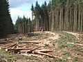
In the South of the Park, timber harvesting is integral to management of Kielder Forest.
-
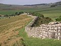
Hadrian's Wall is historically important, and is part of the National Park's significance
-
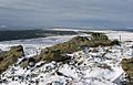
Sighty Cragg
-
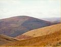
Shillhope Law


See also
 In Spanish: Parque nacional de Northumberland para niños
