Tosson Hill facts for kids
Quick facts for kids Toss Hill |
|
|---|---|

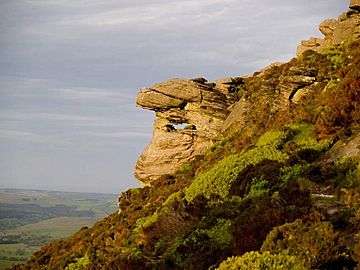
Simonside Crag, on the eastern slopes
|
|
| Highest point | |
| Elevation | 440 (1,444 ft) |
| Prominence | 247 m (810 ft) |
| Parent peak | The Cheviot |
| Listing | Marilyn |
| Geography | |
| Location | Simonside Hills, England |
| OS grid | NZ005982 |
| Topo map | OS Landranger 81 |
Tosson Hill is the tallest hill in the Simonside Hills. These hills are located south of Rothbury in Northumberland, England. The very top of Tosson Hill is about 2 kilometers (1.2 miles) west of Simonside. Simonside is the most well-known peak in the Simonside Hills.
Discovering Tosson Hill
Getting to the Top
The summit of Tosson Hill is about 1 kilometer (0.6 miles) west of the edge of the Simonside Forest. This forest is managed by the Forestry Commission. For a long time, people could not easily reach the very top of Tosson Hill.
However, things have changed! Now, this area is known as 'access land'. This means people can explore it freely. This change happened thanks to the Countryside and Rights of Way Act 2000. This law helps more people enjoy the countryside.
Rock Climbing Adventures
On the northern side of Tosson Hill, you will find some cool sandstone cliffs called Ravensheugh. These cliffs are a great spot for rock climbing. They offer many short climbing routes for different skill levels.
Ravensheugh is often less crowded than other climbing spots inside the Simonside Forest. This makes it a good choice if you are looking for a quieter climbing experience.
 | Ernest Everett Just |
 | Mary Jackson |
 | Emmett Chappelle |
 | Marie Maynard Daly |

