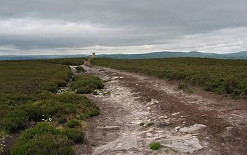
Long Crag facts for kids
Quick facts for kids Long Crag |
|
|---|---|

Long Crag summit
|
|
| Highest point | |
| Elevation | 319 m (1,047 ft) |
| Prominence | c. 169 m |
| Parent peak | The Cheviot |
| Listing | Marilyn |
| Geography | |
| Location | Northumberland, England |
| OS grid | NU062069 |
| Topo map | OS Landranger 81 |
Long Crag is a cool hill located in Northumberland, England. It stands to the north of a town called Rothbury. This hill is a popular spot for outdoor adventures, especially within the beautiful Thrunton Woods. This area is managed by the Forestry Commission, which means it's a great place for hiking and exploring nature.
Contents
Discovering Long Crag
Long Crag stands tall at 319 meters (about 1,047 feet) above sea level. It's part of the stunning landscape of Northumberland, a county in northern England. This hill is known as a "Marilyn," which is a special term for hills that are at least 150 meters (about 492 feet) high. Long Crag is connected to a larger peak called The Cheviot, which is the highest point in the Cheviot Hills.
Exploring Thrunton Woods
Long Crag is found right inside Thrunton Woods. These woods are a large area filled with trees, mostly planted by the Forestry Commission. The Forestry Commission is a government department in the UK that looks after forests and woodlands. They make sure these areas are healthy and safe for people to enjoy.
Fun Activities in the Woods
Thrunton Woods is a fantastic place for outdoor activities. The Forestry Commission has created many marked trails for visitors. These trails are perfect for:
- Hiking: You can follow different paths that lead through the trees and up towards the summit of Long Crag.
- Walking: Even if you don't want to reach the very top, there are plenty of easier walks to enjoy the scenery.
- Nature Spotting: The woods are home to various plants and animals. Keep an eye out for different birds, insects, and maybe even some small mammals.
There are many different ways to reach the top of Long Crag. You can choose a route that matches how much you like to hike. Some paths are steeper, while others are more gradual. No matter which way you go, you'll get to enjoy the fresh air and beautiful views of the Northumberland countryside.
What is a Marilyn?
You might have noticed that Long Crag is called a "Marilyn." This is a special classification for hills and mountains in the United Kingdom, Ireland, and surrounding islands. To be a Marilyn, a hill must have a "relative height" or "prominence" of at least 150 meters (about 492 feet).
Prominence Explained
Prominence means how much a hill rises above the lowest point connecting it to any higher ground. Think of it like this: if you imagine water filling up the landscape, a Marilyn would be an island that sticks out at least 150 meters above the water level. This makes Marilyns stand out in the landscape, offering great views from their summits. Long Crag has a prominence of about 169 meters, which easily makes it a Marilyn!
 | Calvin Brent |
 | Walter T. Bailey |
 | Martha Cassell Thompson |
 | Alberta Jeannette Cassell |

