Ill Crag facts for kids
Quick facts for kids Ill Crag |
|
|---|---|

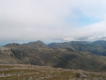
On the Ill Crag plateau
|
|
| Highest point | |
| Elevation | 935 m (3,068 ft) |
| Prominence | 57 m (187 ft) |
| Parent peak | Scafell Pike |
| Listing | Hewitt, Nuttall |
| Geography | |
| Parent range | Southern Fells |
| OS grid | NY223073 |
| Topo map | OS Landrangers 89, 90 |
| Climbing | |
| Easiest route | From Esk Hause |
Ill Crag is a tall mountain, also known as a fell, located in the beautiful Lake District in England. It stands at about 935 meters (3,068 feet) high. This makes it the fifth-highest peak in England! Only Scafell Pike, Sca Fell, Helvellyn, and Skiddaw are taller. From Ill Crag, you can see amazing views of Eskdale and other mountains like Bowfell and Crinkle Crags.
Where is Ill Crag Located?
Ill Crag is part of a group of mountains called the Scafell chain. It is found about 1 kilometer (0.6 miles) east of Scafell Pike, which is England's highest mountain. Another peak called Broad Crag is right next to Ill Crag, sitting between it and Scafell Pike.
Climbing Ill Crag
Many people climb Ill Crag when they are on their way to the top of Scafell Pike. There is a path that leads from a place called Esk Hause. However, the very top of Ill Crag is quite rocky, which can make it slow to walk across. Because of this, some hikers choose to walk past it without going all the way to the summit. The actual summit of Ill Crag is a few hundred meters south of the main path that goes from Esk Hause to Scafell Pike.
 | James B. Knighten |
 | Azellia White |
 | Willa Brown |


