
River Conwy facts for kids
Quick facts for kids Conwy |
|
|---|---|

Boats in the river estuary at Conwy
|
|
| Other name(s) | Welsh: Afon Conwy |
| Country | Wales |
| District | County Borough of Conwy |
| City | Conwy |
| Physical characteristics | |
| Main source | Migneint moor where a number of small streams flow into Llyn Conwy, Gwynedd |
| River mouth | Conwy estuary Irish Sea, Wales |
| Length | 55 km (34 mi) |
| Depth |
|
| Basin features | |
| Tributaries | |
The River Conwy (which is Afon Conwy in Welsh) is an important river in north Wales. It flows for about 55 kilometers (34 miles) from its starting point to where it meets the sea in Conwy Bay. The river and its surrounding area cover about 678 square kilometers. The name 'Conwy' comes from old Welsh words: cyn meaning 'chief' and gwy meaning 'water'. So, it was originally called the 'Cynwy', meaning 'chief water'.
The River Conwy begins on the Migneint moor, where several small streams flow into Llyn Conwy (Llyn means lake in Welsh). From there, it mostly flows north. Along its journey, other rivers join it, like the Machno and Lledr. It then reaches Betws-y-Coed, where the Afon Llugwy also joins. The river continues north through towns like Llanrwst, Trefriw, and Dolgarrog. Finally, it reaches Conwy Bay at the town of Conwy. During certain high tides in spring, the river's water can be affected by the sea as far inland as Llanrwst.
Contents
What Is the Conwy River's Journey Like?
The River Conwy starts its journey in the Migneint moor, a high, open area. It flows into Llyn Conwy, a lake that acts as its main source.
- From the Source: The river flows generally north.
- Joining Other Rivers: It is joined by several smaller rivers, called tributaries. Key ones include the Machno and Lledr.
- Passing Through Towns: The Conwy flows past well-known places like Betws-y-Coed, Llanrwst, Trefriw, and Dolgarrog.
- Reaching the Sea: The river eventually empties into the Irish Sea at Conwy Bay.
What Is the Land Around the River Conwy Like?
The area around the River Conwy has different types of land and rocks.
- Eastern Side: To the east, you'll find old, rolling hills made of mudstone. These rocks are from the Silurian period, which was a very long time ago. The soil here is often thin and acidic, and the land is covered in moor-grass and heather. This means the water flowing into the river from this side can be a bit acidic and sometimes brownish.
- Western Side: On the west, the rocks are even older, from the Cambrian period. These rocks are harder, creating a more dramatic landscape with tall, rocky hills and mountains. The river here often flows in fast-moving sections and waterfalls. You can see amazing examples of these river features at Conwy Falls. Many areas on the eastern side are covered with planted conifer trees.
- Minerals and Mines: The rocks on the western side are rich in minerals. People have mined copper, lead, and silver here since Roman times, and you can still find many old mine sites.
- Valley Floor: Downstream from Betws-y-Coed, the river valley becomes wider and more fertile. This area is good for dairying (making milk products) and raising sheep. In winter, farmers bring their sheep down from the mountains to these pastures to protect them from the harsh weather.
Why Is the Conwy Estuary Special?
The area where the River Conwy meets the sea is called the Aber Afon Conwy. It is a very important place, known as a Site of Special Scientific Interest (SSSI). This means it's protected because of its unique plants and animals, both in the water and on land.
- Tidal Reach: The part of the river affected by the ocean's tides stretches for about 16 kilometers (10 miles) inland.
- Diverse Shoreline: The shoreline here is very varied. It has natural rocks, clay cliffs, sand dunes, salt marshes, and even woodlands. This mix of habitats supports many different kinds of wildlife.
What Is the History and Culture of the Conwy Valley?
The communities along the Conwy valley have a long and interesting history.
- Ancient Homes: People have lived here since the Stone Age. The Romans were also here until about 400 AD, and people have lived in the valley continuously since then.
- Old Churches: The valley is home to two of the oldest churches in Wales: one in Llanrhychwyn (from the 11th century) and another in Llangelynin (from the 12th century).
- Wars of the Roses: In 1466, during the Wars of the Roses, much of the Conwy valley was destroyed by the Earl of Pembroke. This happened after a Lancastrian attack on the town of Denbigh.
- Conwy Town and Bridges: At the mouth of the river is the historic town of Conwy. It has a famous World Heritage Site castle. There are also two well-known bridges:
- One of the first road suspension bridges, built by Thomas Telford, is now used as a footpath.
- Robert Stephenson's unique tubular iron bridge still carries the main railway line from Holyhead to London.
- Modern Crossing: A third bridge now carries road traffic. More recently, the A55 highway goes through a tunnel built under the estuary.
How Clean Is the River Conwy's Water?
The quality of the River Conwy's water is regularly checked by Natural Resources Wales.
- Water Acidity: Near its source, the river water tends to be acidic. As it flows towards the sea, the water's conductivity increases, but its overall quality remains very good. There are only slight increases in ammonia from farms.
- Flood Warnings: Natural Resources Wales also keeps a close eye on water levels in the valley to give flood warnings when needed. They have measuring stations in places like Betws-y-Coed, Llanrwst, and Trefriw.
- Fish Life: The Conwy is famous for its salmon and sea trout. However, the water became more acidic in the late 1900s, especially in the upland areas. This made it harder for the fish to lay their eggs. To help, an artificial fish pass was built in the 1990s. This allows salmon and trout to swim past Conwy Falls to reach areas further upstream to spawn.
- Conwy Crossing Tunnel: In the late 1980s and early 1990s, a special tunnel called the Conwy Crossing was built under the estuary. It was opened by the Queen in 1991. While building it meant losing some saltmarsh, it also led to the creation of the Conwy RSPB Reserve, a protected area for birds.
- Wind Farm: Since 2002, the Moel Maelogan wind farm has overlooked the valley, with its turbines generating electricity.
Images for kids
-
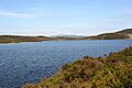
Llyn Conwy, where the River Conwy begins its journey.
-
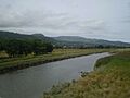
The River Conwy flowing near Dolgarrog.
-
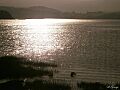
The River Conwy by Glan Conwy Railway Station.
-
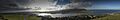
A wide view of the Conwy Estuary and Conwy Castle.


See also
 In Spanish: Río Conwy para niños
