
Wales Coast Path facts for kids
The Wales Coast Path (Welsh: Llwybr Arfordir Cymru) is a very long walking path that goes all the way around the coast of Wales. It opened on May 5, 2012. This amazing path is about 870-mile (1,400 km) long, stretching from Chepstow in the south to Queensferry in the north.


Wales is the first country in the whole world to create a walking path along its entire coastline! The Path goes through many special places, including eleven National Nature Reserves. These are places where nature is protected. Some parts are also managed by groups like The Wildlife Trusts and the Royal Society for the Protection of Birds (RSPB), which help birds and other animals. In 2012, Lonely Planet magazine even said that the coast of Wales was the best region to visit.
Contents
Discover the Wales Coast Path
The Wales Coast Path officially opened on May 5, 2012. It became the world's first coastal path to cover an entire country. It follows the beautiful Welsh coastline from Chepstow in the southeast all the way up to Queensferry in the north. The path connects many older paths that already existed, like the North Wales Path, the Anglesey Coastal Path, and the Llŷn Coastal Path. The Pembrokeshire Coast Path is a very famous part of it. In 2011, National Geographic magazine called it the second-best coastal place in the world!
Exploring the Path
The path is 870 miles (1,400 km) long and takes you through many different kinds of coastal areas. You can see the mouth of the River Dee, visit fun seaside towns in north Wales, and walk along the Menai Strait. It also goes around the Isle of Anglesey, the Llŷn Peninsula, and Cardigan Bay. You'll find miles of sandy beaches in the National Park in Pembrokeshire, and explore areas like Gower, Cardiff Bay, and Cardiff, before reaching Chepstow.
Most of the path is perfect for walkers. But some parts are also great for cyclists, families with pushchairs, people who use wheelchairs, and even horse riders. This means many different people can enjoy the path!
How the Path Was Created
The Countryside Council for Wales (which is now called Natural Resources Wales) helped create the path. Each of the 15 local government areas that the path crosses helps to look after their own section. Before the full path was made, there were already five coastal paths in places like Pembrokeshire and Anglesey. These older paths became important parts of the new, bigger Wales Coast Path.
The idea for the path came from how successful the Pembrokeshire Coast Path and the Anglesey Coastal Path were. In 2006, the First Minister of Wales, Rhodri Morgan, shared the plans for the path. It was thought it would take about five years to build, but it took closer to six. These paths bring a lot of money to Wales because many visitors come to walk them. The path also helps people in Wales and visitors to get outside, enjoy nature, and stay healthy.
The people who manage the path said that they would keep making it better. The goal is for the path to stay as close to the coastline as possible, as long as it's safe. They also hope the path will lead to shorter circular walks that connect to towns and villages further inland.
Celebrating the Opening
The official opening of the 870 miles (1,400 km) path happened in many different places on May 5, 2012. These events showed how beautiful the path is and how easy it is for people of all ages and fitness levels to use. To celebrate, a group called Ramblers Cymru organized the "Big Welsh Coastal Walk." Over 5,500 people joined in!
There are also official guidebooks being written for different parts of the Wales Coast Path. These books help walkers find their way and learn more about the areas they are exploring.
One year after the path opened, its success was talked about on radio and television. It's thought that about 2.8 million people walked parts of the path in that first year. This brought about £16 million into the Welsh economy! More than 800,000 visitors who walked the path also stayed overnight in local guesthouses, B&Bs, and hotels along the route.
A Full Walk Around Wales
The 870 miles (1,400 km) Wales Coast Path connects with another famous path called the Offa's Dyke Path. This other path follows the border between Wales and England. When you combine both paths, you can walk almost all the way around Wales! This makes a huge walking route of about 1,030 miles (1,660 km).
| Sections of the path (from north to south) | Route on map |
|---|---|
| North Wales Coast & Dee Estuary - includes the North Wales Path, which opened in 1997. | |
| Isle of Anglesey - includes the Anglesey Coastal Path, which opened in 2006. | |
| Menai, Llŷn & Meirionnydd - includes the Llŷn Coastal Path, opened in 2006. | |
| Ceredigion - see the Ceredigion Coast Path, which opened in 2008. | |
| Pembrokeshire - includes the Pembrokeshire Coast Path, a National Trail that opened in 1970. | |
| Carmarthenshire - includes the Millennium Coastal Park near Llanelli. | |
| Gower & Swansea Bay - includes the Gower and Swansea Bay Coast Path, which opened in 2012. | |
| South Wales Coast & Severn Estuary - includes the South Wales Coast and Severn Estuary Coastal Path, which opened in 2012. |


Challenges Along the Path
Sometimes, the path has to go on roads instead of right next to the sea. This happens when landowners don't allow the path to cross their land. About 20% of the path is on roads, but most of these are quiet country lanes. This is actually a bit less than the average for other long trails in Britain.
Images for kids
-
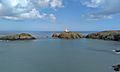
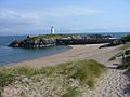
Strumble Head lighthouse, looking across Carreg Onnen Bay
-
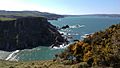
The Pembrokeshire Coast path near Ceibwr Bay, looking north towards Cemaes Head
-
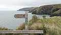
The Pembrokeshire Coast Path between Pwllgwaelod and Fishguard
-
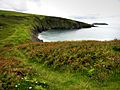
Above the beach at Mwnt
-
Newborough beach and Llanddwyn Island


See also
 In Spanish: Sendero de la costa de Gales para niños
