
Pembrokeshire facts for kids
Quick facts for kids
Pembrokeshire
Sir Benfro (Welsh)
|
||
|---|---|---|

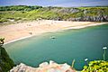
Tenby in southeast Pembrokeshire
|
||
|
||

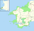
Pembrokeshire's location in Wales
|
||
| Sovereign state | United Kingdom | |
| Country | Wales | |
| Preserved county | Dyfed | |
| Admin HQ | Haverfordwest | |
| Largest town | Haverfordwest | |
| Government | ||
| • Type | Pembrokeshire County Council | |
| Area | ||
| • Total | 610 sq mi (1,590 km2) | |
| Area rank | 5th largest Welsh county | |
| Population
(2015)
|
||
| • Total | 123,500 | |
| • Rank | Ranked 13th in Wales | |
| • Density | 200/sq mi (76/km2) | |
| • Density rank | 19th | |
| • Ethnicity | 99.2% White | |
| Welsh language | ||
| • Rank | Ranked 8th | |
| • Speakers | 17.2% | |
| Geocode | 00NS (ONS) W06000009 (GSS) |
|
| ISO 3166 code | GB-PEM | |

Pembrokeshire (pronounced PEM-bruuk-sheer) is a beautiful county located in the southwest of Wales. It's mostly surrounded by the sea, with Carmarthenshire to its east and Ceredigion to its northeast. The main town and administrative center is Haverfordwest.
This area is generally quiet and rural, covering about 1,590 square kilometers and home to around 123,400 people. Besides Haverfordwest, other important towns include Milford Haven, Pembroke Dock, and Pembroke. St Davids is a city, but it's the smallest one in the UK by population. About 17% of the people here speak Welsh, especially in the northern parts of the county.
Pembrokeshire is famous for its amazing coastline, which has tall sea cliffs, wide sandy beaches, and the large natural harbor of Milford Haven. Many offshore islands are home to lots of seabirds. Most of the coast is protected as part of the Pembrokeshire Coast National Park. You can hike along the 306-kilometer-long Pembrokeshire Coast Path. The inland areas are mostly flat, except for the Preseli Mountains in the north.
The county has many ancient sites, especially in the Preseli Mountains. In the Middle Ages, Normans built castles like Pembroke and Cilgerran. St David's Cathedral became a very important place for pilgrims. Even during the Industrial Revolution, Pembrokeshire stayed mostly rural, except for Milford Haven, which grew as a port. Today, the county's economy relies on farming, oil and gas, and especially tourism.
Contents
- Pembrokeshire: A Welsh Coastal Gem
- Towns and Cities in Pembrokeshire
- Pembrokeshire's Amazing Geography
- Pembrokeshire's Wild Animals and Plants
- A Journey Through Pembrokeshire's History
- People and Languages of Pembrokeshire
- How Pembrokeshire is Governed
- Getting Around Pembrokeshire
- Pembrokeshire's Economy: How People Make a Living
- Pembrokeshire's Culture and Fun Facts
- Famous People from Pembrokeshire
- Schools and Hospitals in Pembrokeshire
- Images for kids
Pembrokeshire: A Welsh Coastal Gem
Towns and Cities in Pembrokeshire
The main town in Pembrokeshire is Haverfordwest. Other towns include Pembroke, Pembroke Dock, Milford Haven, Fishguard, Tenby, Narberth, Neyland, and Newport. In the west, St Davids is the UK's smallest city, with a population of only 1,841 people in 2011. Saundersfoot is the largest village, with over 2,500 residents. Only a small part of the county is built-up or urban.
Pembrokeshire's Amazing Geography
Weather and Climate
Pembrokeshire has a mild climate, especially along the coast, thanks to the warm Atlantic Ocean. This means winters are not too cold. Temperatures are slightly lower in areas that are higher up, like Penycwm.
The air quality in Pembrokeshire is generally very good, with a "Good" rating for air pollution.
How Pembrokeshire's Land Was Formed
The rocks in Pembrokeshire were formed between 600 and 290 million years ago. About 60 million years ago, the land rose, and sea levels fell, revealing the younger rocks that contain the Pembrokeshire Coalfield. Ice ages also shaped the landscape, scraping away soil and deepening river valleys about 20,000 years ago. While earthquakes are rare, there was a series of strong ones in August 1892.
Stunning Coastline and Islands

Pembrokeshire's coastline is full of beautiful bays and sandy beaches. The Pembrokeshire Coast National Park covers more than a third of the county. It's the only UK national park created mainly for its coastline. The park includes the 306-kilometer-long Pembrokeshire Coast Path, which stretches from Amroth in the southeast to St Dogmaels in the north. The National Trust owns about 96 kilometers of Pembrokeshire's coast. No place in the county is more than 16 kilometers from the sea.
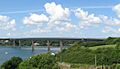
The large natural harbor of Milford Haven cuts deep into the coast. Since 1975, the Cleddau Bridge has crossed this estuary, connecting Neyland and Pembroke Dock. Major bays include Newport Bay, Fishguard Bay, St Bride's Bay, and western Carmarthen Bay. There are several small islands off the coast, such as Ramsey, Grassholm, Skokholm, Skomer, and Caldey. The seas around Skomer and Skokholm are protected areas for marine life.
Many shipwrecks are found off the Pembrokeshire coast. A Viking wreck near The Smalls is protected. The county has six lifeboat stations that help with sea rescues.

The varied geology of Pembrokeshire led to the creation of the Pembrokeshire Coast National Park. In the north are the Preseli Mountains, wide areas of high moorland where sheep graze. These mountains have many ancient sites and are thought to be the source of the bluestones used to build Stonehenge in England. The highest point is Foel Cwmcerwyn, at 536 meters. Most of the land in the county (86%) is used for farming.
Pembrokeshire's Wild Animals and Plants
Pembrokeshire has a wide variety of wildlife, living in marine, estuary, woodland, moorland, and farmland habitats. Many seabirds, like razorbills, guillemots, puffins, and Manx shearwaters, breed here. Rare birds like the red-billed chough are also found. Grassholm has a huge colony of gannets.
You can often spot seals, dolphins, and porpoises off the coast. Sometimes, even whales are seen! In 2021, a rare walrus visited. Pembrokeshire is also one of the few places in the UK where the rare Southern damselfly lives.
A Journey Through Pembrokeshire's History
Ancient Times: Early People

People have lived in the Pembrokeshire area for a very long time, possibly as far back as 125,000 years ago. There are many prehistoric sites, like Pentre Ifan, and remains from the neolithic period (12,000 to 6,500 years ago). In 2018, a 1st-century Celtic chariot burial was found, the first of its kind in Wales.
Roman Times: A Quiet Corner
There isn't much evidence of Roman occupation in Pembrokeshire. Most Roman writers didn't mention the area. Some Roman coins and weapons have been found, but it's not clear if they belonged to Romans or local people who had adopted Roman ways.
Irish Settlers and Vikings
Between 350 and 400 AD, an Irish tribe called the Déisi settled in the region. They mixed with the local Welsh people, and the area became known as Dyfed. Later, Vikings raided the coast and set up trading posts in places like Haverfordwest and Fishguard.
Norman Castles and Welsh Princes

Around 1067 to 1111, Normans and Flemings invaded the area, which then became known as Pembroke, named after the Norman castle. In 1136, Prince Owain Gwynedd defeated a large Norman army, but the Normans still had a strong influence. Rhys ap Gruffydd, a Welsh prince, later regained much control.
Henry Tudor, who was born at Pembroke Castle in 1457, landed an army in Pembrokeshire in 1485. He marched to England, gathered more support, and defeated King Richard III at the Battle of Bosworth Field. Henry became the first king of the House of Tudor.
Tudor and Stuart Eras

In 1535, a law divided the county into seven areas called hundreds, which were similar to the old Welsh regions. The Elizabethan era brought new wealth to Pembrokeshire through farming, mining, and fishing.
During the First English Civil War (1642–1646), Pembrokeshire supported the Parliamentarians, unlike most of Wales, which supported the King. However, an event in Pembrokeshire started the Second English Civil War when local soldiers rebelled. Oliver Cromwell defeated them at the Siege of Pembroke in 1648.
The 18th and 19th Centuries
In 1720, Pembrokeshire had five market towns, 45 parishes, and about 4,329 houses. Roads were often in poor condition. In 1797, the French tried to invade Britain by landing in Fishguard, but they failed. French prisoners were held at Golden Hill Farm in Pembroke. By 1831, the county had a population of 81,424.
Towards the end of the 19th century, running water was finally brought to rural south Pembrokeshire through a reservoir at Rosebush.
Pembrokeshire in the 20th Century

Throughout the 20th century, Pembrokeshire's population stayed steady. There was a lot of military activity here during the World Wars. German U-boats were active off the coast in World War I, and in World War II, there were military exercises and airfields. Many aircraft accidents happened due to the difficult terrain. From 1943 to 1944, 5,000 American soldiers were based here, getting ready for D-Day. After the war, German prisoners were held in Pembrokeshire. The County of Pembroke War Memorial in Haverfordwest lists the names of 1,200 people who died in World War I.
In 1972, a second reservoir was built at Llys y Fran to supply water to south Pembrokeshire.
People and Languages of Pembrokeshire
How Many People Live Here?
In 2021, Pembrokeshire had about 123,400 people. Most residents (66.4%) were born in Wales, and 27.5% were born in England.
Speaking Welsh in Pembrokeshire

The 2021 census showed that 17.2% of the population speaks Welsh. This number is lower in the south (about 15%) than in the north (about 50%) due to historical immigration. The imaginary line between these two areas is called the Landsker Line. The area south of this line is sometimes called "Little England Beyond Wales".
Beliefs and Backgrounds
In 2021, 48.8% of people in Pembrokeshire identified as Christian, while 43% reported having "no religion." Most residents (99%) are white European.
How Pembrokeshire is Governed
.jpg)
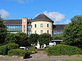
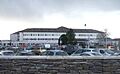
Pembrokeshire has its own elected local government, the Pembrokeshire County Council. It was first set up in 1888. In 1972, Pembrokeshire became part of a larger county called Dyfed. But in 1996, Dyfed was broken up, and Pembrokeshire became a separate local authority again. The council's main office is at County Hall in Haverfordwest.
.jpg)
Pembrokeshire also sends two Members of Parliament (MPs) to the UK Parliament in Westminster and two Members of the Senedd (MSs) to the Welsh Parliament in Cardiff.
The county's emergency services include the Mid and West Wales Fire and Rescue Service and Dyfed-Powys Police.
Getting Around Pembrokeshire
Pembrokeshire does not have any motorways. The main roads are the A40, which goes through Haverfordwest and Fishguard, and the A477, which crosses the Cleddau Bridge. The A478 connects Tenby in the south to Cardigan in the north.
Regular bus and train services connect the main towns. Trains from Milford Haven can take you directly to Manchester. There are also ferry services to Ireland from Pembroke Dock and Fishguard. Smaller ferries take visitors to islands like Caldey Island and Skomer Island. Haverfordwest Airport handles smaller planes.
Pembrokeshire's Economy: How People Make a Living
Pembrokeshire's economy now relies a lot on tourism. Farming is also very important, though it used to be the biggest industry. Mining for slate and coal largely stopped by the 20th century. Since the 1950s, industries related to oil and gas have grown along the Milford Haven Waterway.
The Pembrokeshire County Show, a large agricultural event, attracts many visitors each year.
Farming and Food
.jpg)
For centuries, much of Pembrokeshire's land has been used for farming. The county has good soil and a mild climate, which helps crops grow well. Pembrokeshire is known for its new potatoes, which often appear in British shops earlier than potatoes from other parts of the UK. Other main crops include oilseed rape, wheat, and barley. Dairy farming (for milk and cheese), beef production, and sheep farming are also important.
The county is home to the Pembroke Welsh Corgi, a type of herding dog. There are still working woollen mills, like Solva and Tregwynt.
Fishing Industry

Fishing has been an important industry in Pembrokeshire for a long time, especially around Milford Haven. While the large-scale commercial fishing has reduced, some fishing still takes place. The biennial Pembrokeshire Fish Week celebrates the local fishing industry.
Energy and Industry

Milford Haven is home to two oil refineries, two terminals for liquified natural gas (LNG), and the large Pembroke Power Station, which generates electricity using gas. A long pipeline connects Milford Haven to Gloucestershire.
Pembrokeshire is also exploring renewable energy sources. The first underwater turbine was installed in Ramsey Sound in 2015. In 2011, the first solar energy farm in Wales was built in Rhoshill, generating electricity from 10,000 solar panels.
Tourism: Welcoming Visitors
Tourism is a huge part of Pembrokeshire's economy. In 2015, 4.3 million tourists visited, spending £585 million and supporting over 11,800 jobs. Many of Pembrokeshire's beaches have won awards, including Blue Flag status. In 2019, 39 Pembrokeshire beaches were recognized for their quality.

The Pembrokeshire coastline is a big attraction. National Geographic Traveller magazine once called it the second best coastline in the world. Pembrokeshire is also a "dark sky" destination, great for stargazing. The many shipwrecks attract divers. Recently, Atlantic bluefin tuna have returned, creating opportunities for sport fishing.
The county has several theme parks and animal parks, like Folly Farm Adventure Park and Zoo and Oakwood Theme Park. There are also museums, art galleries, and theaters. You can find 21 marked cycle trails for biking.
Pembrokeshire's Culture and Fun Facts
The Pembrokeshire Flag
The flag of Pembrokeshire is blue with a yellow cross. In the middle of the cross is a green shape with a red and white Tudor rose.
Historic Buildings and Sites

Pembrokeshire has over 1,600 listed buildings, from ancient huts to grand castles and bridges. The National Trust owns 10 properties here.
Arts, Music, and Movies
Pembrokeshire hosts music festivals in St Davids, Fishguard, and Tenby. The Torch Theatre in Milford Haven shows plays and films. There are also museums and art galleries in various towns. In Fishguard, you can see the 30-meter-long Last Invasion Tapestry, which tells the story of the 1797 French invasion.
Pembrokeshire's beautiful coastal scenery and historic buildings make it a popular place for filming movies and TV shows. For example, scenes from Moby Dick were filmed in Fishguard, and parts of the last two Harry Potter movies were shot at Freshwater West.
| Year | Film title | Location | |
|---|---|---|---|
| 1940 | The Thief of Bagdad | Freshwater West | |
| 1956 | Moby Dick | Fishguard | |
| 1961 | Fury at Smugglers' Bay | Abereiddy | |
| 1968 | The Lion in Winter | Pembroke Castle, Marloes Sands, Milford Haven | |
| 1972 | Under Milk Wood | Fishguard | |
| 1977 | Jabberwocky | Pembroke Castle & Bosherston | |
| 1994 | Dragonworld | Manorbier | |
| 1994 | The Lifeboat (BBC TV) | Pembrokeshire Coast | |
| 1998 | Basil | Tenby, Manorbier, Bosherston | |
| 2003 | Baltic Storm | Fishguard | |
| 2003 | I Capture The Castle | Manorbier Castle | |
| 2008 | The Edge of Love | Tenby & Laugharne | |
| 2010 | Harry Potter and the Deathly Hallows – Part 1 | Freshwater West | |
| 2010 | Robin Hood | Freshwater West | |
| 2010 | Third Star | Barafundle Bay, Stackpole Estate | |
| 2011 | Harry Potter and the Deathly Hallows – Part 2 | Freshwater West | |
| 2012 | Snow White and the Huntsman | Marloes Sands | |
| 2015 | Under Milk Wood | Solva | |
| 2015 | The Bad Education Movie | Pembroke Castle | |
| 2016 | Their Finest | Trecwn, Haverfordwest, Cresswell Quay, Freshwater West, Porthgain | |
| 2016 | Me Before You | Pembroke, Pembroke Castle | |
| 2020 | The Pembrokeshire Murders (TV series) | Goodwick, Fishguard, Freshwater East, coast path | |
| 2021 | The Toll | Dale, Preseli Mountains, Rosebush, Scolton Manor |
Pembrokeshire has several local newspapers, including the Western Telegraph. There were also local radio stations based in Narberth and Milford Haven.
Sports and Activities
Rugby union is very popular in Pembrokeshire, with teams in many towns and villages. There are also many football clubs.
The Ironman Wales event has been held in Pembrokeshire since 2011, bringing in millions of pounds for the local economy. The Ras Beca, a challenging running race, has been held in the Preseli Mountains since 1977.
Cycling is also popular, with the annual Tour of Pembrokeshire road-cycling event attracting many riders. Part of the Celtic Trail cycle route runs through the county. The Blue Lagoon at Abereiddy has hosted rounds of the Red Bull Cliff Diving World Series. The Welsh National Surfing Championships are held at Freshwater West.
Cricket is played throughout the county, with many village teams.
Famous People from Pembrokeshire

Many notable people have come from Pembrokeshire. Rhys ap Gruffydd, a Welsh ruler, was buried in St Davids Cathedral. Gerald of Wales, a famous writer, was born at Manorbier Castle. Henry Tudor, who became King of England, was born at Pembroke Castle in 1457.
The famous pirate Bartholomew Roberts (also known as Black Bart) was born near Fishguard in 1682.
In more recent times, the artists Gwen and Augustus John were born here, as was the novelist Sarah Waters. Singer Connie Fisher grew up in Pembrokeshire, and actor Christian Bale was born in Haverfordwest.
Stephen Crabb and Simon Hart, who have both served as government ministers, are Members of Parliament for Pembrokeshire constituencies.
Schools and Hospitals in Pembrokeshire

In 2018, Pembrokeshire had 58 primary schools, eight secondary schools, and one special school, educating over 18,300 students. Many schools offer education through the medium of Welsh.
Health services are provided by the Hywel Dda University Health Board. The main hospital in the county is Withybush General Hospital in Haverfordwest, with smaller hospitals in Tenby and Pembroke Dock.
Images for kids
-
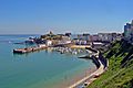
Tenby in southeast Pembrokeshire
-
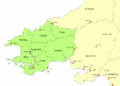
Pembrokeshire Coast National Park shown in green
-
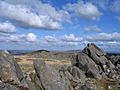
View from the bluestone quarry to other peaks in the Preselis
-
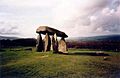
Pentre Ifan neolithic burial chamber
-
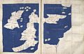
Map dated 1450-75 based on Ptolemy's "Geography" written c. 150
-
Dyfed, after the late 7th century, showing its seven cantrefi
-
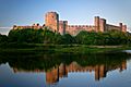
Pembroke Castle, birthplace of Henry VII
-
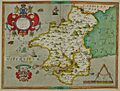
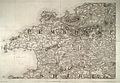
Hand-drawn map of Pembrokeshire by Christopher Saxton from 1577
-
1819 Ordnance Survey map of north and west Pembrokeshire
-
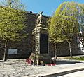
Pembrokeshire County War Memorial, near County Hall
-
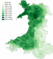
Proportion of Welsh speakers (Wales 2011 census) in Pembrokeshire (county border shown by white line)
-
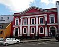
The Shire Hall, Haverfordwest
-
County Hall, Haverfordwest
-
Cleddau Bridge
-
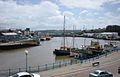
Milford Haven dock, 2009
-
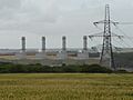
Pembroke Power Station in 2013
-
Barafundle Beach, a recipient of both the 2019 Seaside and Green Coastal awards
-

Henry VII (1505)
-
Withybush General Hospital, Haverfordwest


| Weather chart for Milford Haven | |||||||||||||||||||||||||||||||||||||||||||||||
|---|---|---|---|---|---|---|---|---|---|---|---|---|---|---|---|---|---|---|---|---|---|---|---|---|---|---|---|---|---|---|---|---|---|---|---|---|---|---|---|---|---|---|---|---|---|---|---|
| J | F | M | A | M | J | J | A | S | O | N | D | ||||||||||||||||||||||||||||||||||||
|
115
9
3
|
90
8
3
|
87
10
4
|
61
12
5
|
52
15
7
|
67
17
10
|
53
20
12
|
93
19
12
|
102
17
10
|
131
14
8
|
130
11
5
|
126
10
5
|
||||||||||||||||||||||||||||||||||||
| temperatures in °C precipitation totals in mm source: The Met Office |
|||||||||||||||||||||||||||||||||||||||||||||||
|
Imperial conversion
|
|||||||||||||||||||||||||||||||||||||||||||||||
 In Spanish: Pembrokeshire para niños
