
Saundersfoot facts for kids
Quick facts for kids Saundersfoot
|
|
|---|---|
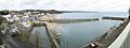
 Saundersfoot harbour and village |
|

Saundersfoot
|
|
| Population | 2,500 (2021 census) |
| OS grid reference | SN136048 |
| Community |
|
| Principal area | |
| Ceremonial county | |
| Country | Wales |
| Sovereign state | United Kingdom |
| Post town | Saundersfoot |
| Postcode district | SA69 |
| Dialling code | 01834 |
| Police | Dyfed-Powys |
| Fire | Mid and West Wales |
| Ambulance | Welsh |
| EU Parliament | Wales |
| UK Parliament |
|
| Welsh Assembly |
|
Saundersfoot (which is Llanusyllt in Welsh) is a large village and community in Pembrokeshire, Wales. It is a popular holiday spot located near Tenby. Saundersfoot is part of the beautiful Pembrokeshire Coast National Park and sits right on the Pembrokeshire Coast Path. In 2021, about 2,500 people lived in the village.
Contents
Discovering Saundersfoot's Past
.jpg)
Long ago, in the Middle Ages, Saundersfoot was known as Llanussyllt. This name came from the local church, which was named after a Welsh saint called Usyllt. After the Normans arrived, the area became known as St. Issels.
In 1578, an old map showed the area as St. Tissels. The church of St. Issell is very old and important. It is a special building because of its history and design. The village grew a lot over time, and by 1833, it had 1,226 people.
Saundersfoot Harbour: From Coal to Cruises
The harbour in Saundersfoot was built a long time ago, in 1829. It was created to help transport a type of coal called anthracite coal from mines nearby. Even before the harbour was built, coal was shipped from the beach for hundreds of years!
The village grew around the port. By 1837, the harbour had five special platforms called jetties. These jetties were used to load coal, iron ore, and other materials like pig iron and firebricks onto ships. There were also special tracks, called tramways, that brought coal from the mines directly to the harbour.
Over time, the mining industry slowed down. By the early 1900s, it had almost completely stopped. Today, the harbour is used for fun activities. You can see private boats, pleasure boats for tourists, and small fishing boats. It's a great place for holidays and enjoying the sea!
How Saundersfoot is Run
Saundersfoot has a local council called the Saundersfoot Community Council. This council helps manage local issues. They look after things like new building plans and keeping public buildings and the cemetery in good condition.
People in Saundersfoot also vote for county councillors. These councillors represent the village at the larger Pembrokeshire County Council. This council makes decisions for the whole county. Until 2022, Saundersfoot was one area that elected one councillor. Now, it is split into two areas: Saundersfoot North and Saundersfoot South. Each of these areas elects its own councillor.
Famous People from Saundersfoot
Saundersfoot has been home to some interesting people:
- William Frost (1848–1935): He was a Welsh designer who created an early flying machine called the Frost Airship Glider.
- Rod de'Ath (1950–2014): A talented Welsh musician who was the drummer for the famous Irish guitarist Rory Gallagher.
- Jay James Picton (born 1983): A Welsh singer and songwriter. He was also a member of the group The Overtones.
Getting Around by Train
The Saundersfoot railway station is about a mile from the centre of the village. You can find it off the B4316 road. Trains stop here every two hours. You can travel west towards Pembroke Dock or east towards Whitland, Carmarthen, and Swansea.
The New Year's Day Swim
Every year, Saundersfoot hosts a fun event called the New Year's Day swim. Many local businesses help to sponsor it. In 2016, more than 1,500 people bravely took a dip in the cold sea! The event was cancelled in 2021 due to COVID-19, but it was back on in 2023. It's a great way to start the new year!
Images for kids
-
Saundersfoot harbour and village
See also
 In Spanish: Saundersfoot para niños
