Dyfed facts for kids
| Dyfed | |
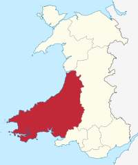
 Dyfed shown as a preserved county since 2003 |
|
| Geography | |
| Status | Non-metropolitan county (1974–1996) Preserved county (1996–) |
| 1974 area | 5,766 km2 |
| 2022 area | 5,774 km2 (1st) |
| HQ | County Hall, Carmarthen |
| History | |
| Origin | Kingdom of Dyfed |
| Created | 1974 |
| Abolished | 1996 |
| Succeeded by | Carmarthenshire, Ceredigion, Pembrokeshire Preserved county of Dyfed |
Quick facts for kids Demography |
|
|---|---|
| 1971 population | 316,369 |
| 1992 population | 351,100 (estimate) |
| 2022 population | 385,094 (5th) |
| Politics | |
| Governance | Dyfed County Council |
 |
|
Dyfed (Welsh pronunciation: [ˈdəvɛd]) is a special type of area in southwestern Wales called a preserved county. It's mostly a countryside area with a long coastline. This coast touches the Irish Sea and the Bristol Channel.
From 1974 to 1996, Dyfed was also the name of the local government that managed the area. Even though that council no longer exists, the name Dyfed is still used today for some official and traditional purposes.
Contents
What Does the Name Dyfed Mean?
The name Dyfed is very old. It comes from an ancient tribe called the Demetae. This tribe lived in the area during the Iron Age.
The tribe's name is linked to the Welsh language word defaid, which means sheep. It's also connected to an older Celtic word, defod, meaning wealth or property. This suggests that the Dyfed area was known for raising sheep a very long time ago. It also implies that sheep farming brought a lot of wealth to the people living there.
The name continued to be used even after the Roman Empire left Britain. It was the name of the Kingdom of Dyfed. Even after the Norman conquest of Wales, people in Pembrokeshire still called the area Dyfed in the 1800s.
How Was Dyfed Formed?
Dyfed was created as an administrative county on April 1, 1974. This happened because of the Local Government Act 1972. It covered roughly the same area as the old Principality of Deheubarth. However, it did not include the Gower Peninsula or the area west of the River Tawe.
The Dyfed County Council was stopped on April 1, 1996. At that time, the three historic counties that made up Dyfed were brought back for local administration. One of these, Cardiganshire, was renamed Ceredigion the very next day.
What Areas Made Up Dyfed?
When Dyfed was an administrative county, it included parts of three older counties. These were Cardiganshire, Carmarthenshire, and Pembrokeshire.
- Cardiganshire became the district of Ceredigion.
- Carmarthenshire was divided into the districts of Carmarthen, Dinefwr, and Llanelli.
- Pembrokeshire became the districts of Preseli (later renamed Preseli Pembrokeshire) and South Pembrokeshire.
Where Was Dyfed's Main Town?
The main administrative office for the Dyfed County Council was in Carmarthen. This town was the headquarters for running the county.
The largest town in Dyfed was Llanelli. Other important towns where many people lived included Haverfordwest, Milford Haven, and Aberystwyth.
Why Is the Name Dyfed Still Used?
Even though the Dyfed County Council was abolished, the name Dyfed is still used for some special purposes. For example, it's used for ceremonial roles like the Lord Lieutenancy.
The name is also part of some regional organizations. These include Dyfed–Powys Police, Dyfed Telecom, and Dyfed Digital. Sometimes, even databases like the Royal Mail continued to use the name Dyfed for addresses until at least 2008. This could sometimes cause confusion when people were shopping online.
What Is the Geography of Dyfed Like?
Dyfed has a very long coastline. To the west, it meets the Irish Sea, and to the south, it meets the Bristol Channel. It shares its borders with other preserved counties: Gwynedd to the north, Powys to the east, and West Glamorgan to the southeast.
Ceredigion: Dyfed's Northern Part
Ceredigion is the northernmost part of Dyfed. It has a narrow strip of land along the coast. The Cambrian Mountains cover a large part of the eastern side of Ceredigion.
The highest point in Ceredigion is Plynlimon, which is 752 meters (2,467 feet) tall. Five rivers start on the slopes of Plynlimon: the Severn, the Wye, the Dulas, the Llyfnant, and the Rheidol. The Severn and Wye flow east into England. The Dulas, Llyfnant, and Rheidol flow west towards the Irish Sea. Further south in Ceredigion, the land is not as mountainous. The River Teifi forms part of the border with Carmarthenshire.
Carmarthenshire: Dyfed's Southeastern Part
Carmarthenshire is in the southeastern part of Dyfed. Most of this area is hilly, except for the river valleys and the coastal strip. The Fforest Fawr and Black Mountain ranges extend into eastern Carmarthenshire. The Cambrian Mountains reach into the north.
The highest point in Carmarthenshire is Fan Foel, which is 781 meters (2,562 feet) high. This peak is on the border with Powys. The River Towy is the largest river here. It flows into the Bristol Channel, as do the River Loughor, the River Gwendraeth, and the River Taf. Carmarthenshire has a long coastline with many deep inlets from these rivers. The south coast has many fishing villages and sandy beaches. The eastern part, around Llanelli and Burry Port, is more industrial.
Pembrokeshire: Dyfed's Southwestern Part
Pembrokeshire is in the southwestern part of Dyfed. It sticks out into the Irish Sea and has a very long, jagged coastline. Pembrokeshire does not have the tall mountains found in other parts of Dyfed. However, much of its inland area is still hilly.
In the north are the Preseli Hills (Mynydd Preseli). This is a wide area of high moorland. The highest point in the Preseli Hills is Foel Cwmcerwyn, which is 536 meters (1,759 feet) tall. This is also the highest point in all of Pembrokeshire.
The largest river is the River Cleddau. It has two main branches that join together to form the Daugleddau estuary. This estuary creates the important harbor of Milford Haven, which opens to the sea in the southwestern corner of the county. The areas around the River Cleddau are mostly flat, low-lying land with many small inlets and creeks. Pembrokeshire's coastline has cliffs in some places, along with many bays and sandy beaches. The county is home to the Pembrokeshire Coast National Park. This park includes the 186-mile long walking trail, the Pembrokeshire Coast Path.
 | Valerie Thomas |
 | Frederick McKinley Jones |
 | George Edward Alcorn Jr. |
 | Thomas Mensah |

