
Pembrokeshire Coast Path facts for kids

The Pembrokeshire Coast Path (also called the Pembrokeshire Coastal Path) is a famous walking path in Pembrokeshire, Wales, in the United Kingdom. Its Welsh name is Llwybr Arfordir Sir Benfro. It is a special National Trail that anyone can walk for free.
The path follows the beautiful coastline of Pembrokeshire. It was officially opened in 1970. The path is about 186 miles (299 km) long. The highest point on the path is Pen yr afr, which is 175 meters (574 feet) high. The lowest point is Sandy Haven crossing, which is only 6 feet (1.8 meters) above the water. As you walk, you will see the sea for most of your journey.
The Pembrokeshire Coast Path starts at a place called Amroth. It then goes north all the way to Poppit Sands. A special sign marks the end, or beginning, of the path at Poppit Sands. The path now continues even further to St Dogmaels. At St Dogmaels, it connects to another path called the Ceredigion Coast Path. The Pembrokeshire Coast Path is also a part of the much longer Wales Coast Path.
Contents
History of the Path
The idea for the Pembrokeshire Coast Path started after the Pembrokeshire Coast National Park was created in 1952. A man named Ronald Lockley explored the coastline in 1953. He wanted to see if a walking path could be made.
At that time, many villages along the coast were hard to reach. People often used boats to visit each other. Lockley suggested building a footpath to connect these areas. Most of the land was public, so people could walk there easily. However, some parts were privately owned. The path organizers had to ask landowners for permission to use their land. Most owners agreed, which was great!
Building the path took 17 years. Workers built 100 footbridges and 479 stiles (steps over fences). They also built thousands of stairs into the ground. The path was officially opened on May 16, 1970, by Wynford Vaughan-Thomas. When it first opened, it was 180 miles (290 km) long. Today, it is 186 miles (299 km) long.
What You Can See Along the Path

Most of the Pembrokeshire Coast Path is inside the Pembrokeshire Coast National Park. The path runs along the Irish Sea. As you walk, you will see many different types of landforms. These include high cliffs, rocky coves, and sandy beaches. There are also headlands (land sticking out into the sea) and valleys shaped by glaciers.
The path passes by 58 beaches and 14 harbors. Most of the path is easy to walk. However, one part goes up and down a lot, climbing a total of 35,000 feet (10,668 meters). There are two spots near the water that can sometimes get flooded: Dale and Sandy Haven. The path also goes through several towns and villages, like Tenby, St Davids, Solva, and Newport.
Nature and Wildlife
The rocks you see along the path are very old, over 300 million years old! The landscape was shaped by the Ice Age. You can see many different kinds of rocks, including igneous rock (formed from cooled lava) and very ancient rocks from before the Cambrian Period.
If you walk the path in Spring or Summer, you will see many beautiful wildflowers. The path is also a great place for birdwatching. Many seabirds live here. If you look out at the water, you might even spot porpoises, dolphins, and seals swimming nearby.
Ancient History Along the Coast
The Pembrokeshire Coast Path goes past many historical sites. Some of these places date back to the Neolithic period (New Stone Age). You can find spots where ancient hut circles once stood. There are also places where people lived during the Bronze Age and Iron Age.
Today, much of the land near the path is used for farming. People also fish off the coast, just like they did in ancient times, but now they use modern tools.

Awards and Recognition
The Pembrokeshire Coast Path has received many awards. In 2011, National Geographic magazine named it the second-best coastal place to visit in the world! The beaches along the path are also very famous. They have won over 300 awards for their quality, beauty, and care for the environment.
Connected Trails
The Pembrokeshire Coast Path connects to other walking trails, including:
- Cilgerran Gorge Circular Walk
- Brunel Way Walk
- Llys-y-Frân Circular Walk
Images for kids
-
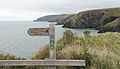
Near Ceibwr Bay, looking north towards Cemaes Head
-
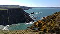
Between Pwllgwaelod and Fishguard
-
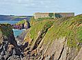
Thorn Island or Thorne Island from West Angle


See also
 In Spanish: Sendero Pembrokeshire para niños
