
Poppit Sands facts for kids
Poppit is a small village found on the southern side of the River Teifi estuary. It's located near Cardigan in northern Pembrokeshire, Wales.
Poppit is most famous for its beautiful sandy beach, known as Poppit Sands. This beach connects with St Dogmaels beach at its eastern end. From Poppit Sands, you can see amazing views across the estuary and bay towards Gwbert and Cardigan Island. The closest village is St Dogmaels, which is about 1½ miles away.
The beach is a special place! It has been awarded a Blue Flag, which means it's very clean and safe. There are also lifeguards and a lifeboat station to help keep everyone safe.


Contents
Exploring Poppit Sands Beach
Poppit Sands is a very popular beach, especially for families. It has lots of interesting features.
Beach Features and Fun
The top part of the beach has soft, dry sand, perfect for building sandcastles! Further down, the sand is harder, which is great for walking or playing games. The beach slopes gently into the sea, so the water stays shallow for a long way out. Even when the tide is high, there's still plenty of soft sand to enjoy.
On the eastern side of the sand dunes, you can see tall sand cliffs, over 4 metres (13 feet) high. New dunes are growing near the path that leads to the beach.
When the tide is fully out, the sand flats at the far south-eastern end stretch for almost a mile. These flats are known as Cardigan Bar. Be careful though, because the currents in the estuary at this end of the beach can be strong and unpredictable.
At the north-western end of the beach, there are cool rock pools. These pools are home to many different kinds of sea creatures!


Wildlife and Plants
The sand dunes at Poppit Sands are very important for wildlife. You can find unusual plants here, like the bee orchid. Park staff look after over 20 hectares (50 acres) of dunes, marsh, and grazing land. They are working to change the willow bushes behind the dunes back into a reed bed, which is a great home for many animals.
In summer, you might spot amazing sea animals in Cardigan Bay! Keep an eye out for bottlenose dolphins, porpoises, and Atlantic grey seals. Sometimes, boat trips leave from Poppit Sands in the summer, specifically for spotting these creatures.
Ancient Fish Trap Discovery
Archaeologists have found a huge 'V'-shaped fish trap in the sea off the Poppit coast. They discovered it by looking at aerial photos. This trap is about 280 yards long and has a wall about 3 feet wide. Today, it's completely underwater, even at low tide.
Experts believe it's about 1,000 years old! Back then, the sea level was lower, and the trap would have appeared at low tide. It would have acted like a shallow rock pool, trapping fish as the tide went out.
Rocks and Land History
The rocks around Poppit are mostly mudstone, which formed in a deep ocean about 450 million years ago. Not many fossils are found here because the water was so deep. You can also see hard sandstone beds, which are up to a metre or two thick at Poppit Sands. These rocks were squeezed and folded by huge movements of the Earth, turning the mudstones into slates. You can see great examples of these folded rocks at the western end of Poppit Sands.
The last warm period between ice ages, called the "Poppit Interglacial," is named after Poppit Sands. This is because there's a perfectly clear example of an old raised beach platform here, just above the high-water mark.
Weather at Poppit Sands
Poppit Sands has a maritime climate, like the rest of the British Isles. This means it has cool summers and mild winters. The nearest official weather station is at Aberporth, which is about 6.5 miles (10.7 km) away.
Usually, the temperature won't go above 25.1°C (77.2°F) more than three days a year. The warmest day might reach about 26.8°C (80.2°F). The highest temperature ever recorded was 32.7°C (90.9°F) in July 2006.
On average, there are about 18 nights with frost, and the coldest night of the year might drop to -4.5°C (23.9°F). The lowest temperature ever recorded was -9.9°C (14.2°F) in January 1963.
Poppit Sands gets about 870mm of rain each year, with rain falling on about 143 days.
| Climate data for Aberporth Weather Station (6.5 Miles ENE of Poppit Sands) at 133m asl, 1971-2000, Extremes 1960-present | |||||||||||||
|---|---|---|---|---|---|---|---|---|---|---|---|---|---|
| Month | Jan | Feb | Mar | Apr | May | Jun | Jul | Aug | Sep | Oct | Nov | Dec | Year |
| Record high °C (°F) | 13.4 (56.1) |
15.2 (59.4) |
21.0 (69.8) |
25.6 (78.1) |
26.6 (79.9) |
31.5 (88.7) |
32.7 (90.9) |
31.5 (88.7) |
25.2 (77.4) |
22.0 (71.6) |
17.0 (62.6) |
14.1 (57.4) |
32.7 (90.9) |
| Mean daily maximum °C (°F) | 7.3 (45.1) |
7.3 (45.1) |
8.7 (47.7) |
10.6 (51.1) |
13.7 (56.7) |
15.9 (60.6) |
18.0 (64.4) |
18.1 (64.6) |
16.1 (61.0) |
13.2 (55.8) |
10.0 (50.0) |
8.3 (46.9) |
12.3 (54.1) |
| Mean daily minimum °C (°F) | 2.9 (37.2) |
2.6 (36.7) |
3.8 (38.8) |
4.9 (40.8) |
7.5 (45.5) |
10.0 (50.0) |
12.2 (54.0) |
12.3 (54.1) |
10.7 (51.3) |
8.4 (47.1) |
5.6 (42.1) |
3.9 (39.0) |
7.1 (44.8) |
| Record low °C (°F) | −9.9 (14.2) |
−7.5 (18.5) |
−6.6 (20.1) |
−2.0 (28.4) |
0.1 (32.2) |
1.7 (35.1) |
5.6 (42.1) |
5.5 (41.9) |
3.3 (37.9) |
−0.9 (30.4) |
−5.0 (23.0) |
−6.0 (21.2) |
−9.9 (14.2) |
| Average precipitation mm (inches) | 88.5 (3.48) |
62.7 (2.47) |
63.7 (2.51) |
50.7 (2.00) |
48.2 (1.90) |
61.1 (2.41) |
49.2 (1.94) |
68.2 (2.69) |
75.7 (2.98) |
104.2 (4.10) |
98.3 (3.87) |
99.2 (3.91) |
870.2 (34.26) |
| Mean monthly sunshine hours | 54.6 | 74.0 | 109.7 | 168.6 | 213.6 | 190.5 | 198.7 | 184.8 | 141.0 | 100.1 | 63.3 | 45.6 | 1,544.5 |
| Source: Met Office | |||||||||||||
Fun Things to Do at Poppit Sands
Poppit Sands is a great place for many activities, from water sports to walking your dog.
Activities and Sports


The beach is a popular spot for surfers and boogie-boarders. You can even find daily surf reports! The hard sand below the high tide line is also perfect for power-kiting, land-boarding, and buggying.
Poppit Sands is a dog-friendly beach. While there are some rules in the summer, a large area is set aside for dog-walkers. The beach and estuary flats are popular with dog-walkers all year round.
Fishing at Poppit
If you enjoy fishing, Poppit Sands offers good catches. In winter, you might catch flounder, cod, and whiting. Mullet can be caught near the river mouth. Salmon and sea trout swim up the river from March to October. Remember, you need a special licence if you want to try catching sea trout on the incoming tide.
Award-Winning Photos
A local photographer named Michael Jackson spent many years taking pictures of Poppit Sands beach, especially from above and at sunset. His amazing work won many awards, and he was a finalist three times for the prestigious Hasselblad Masters. His photos have been shown in galleries around the world and published in a book called Poppit Sands Moonscapes.
Beach Awards and Safety
Poppit Sands is a high-quality beach! It had Blue Flag status until 2013, when it lost it for a short time due to more natural bacteria after a wet year. But it proudly got its Blue Flag status back in 2016 and has kept it since. It has also won a Seaside Award, showing it's a great resort beach.
Lifeguards are on duty at the beach from late June to early September, every day from 10:00 AM to 6:00 PM. It's safe to swim within the area marked by flags.
It's important to know that swimming in the estuary to the south is not advised because of strong currents. Always stay at the main beach where the lifeguards are.
There's also a Poppit Sands Surf Lifesaving Club. In 2011, the club received a grant of £35,980 from the Big Lottery Fund to buy new equipment and welcome more members.
The Lifeboat Station

The first RNLI (Royal National Lifeboat Institution) lifeboat station at Poppit Sands opened in 1971. The original Cardigan lifeboat station was built way back in 1849! It was built after a sad event where the crew of a ship called Agnes Lee were lost. The RNLI took over that station the next year.
In 1876, a new boathouse with a slipway was built. You can still see parts of it down the estuary at Black Rocks. However, this station was closed in 1932. As Poppit Sands became more popular for holidays, more accidents happened, so a new station was built at the current location.
In 1987, a new boathouse was opened for a new type of lifeboat. Then, in 1998, an even newer, bigger boathouse was finished. This one could hold two inshore lifeboats and vehicles, and it had better facilities for the crew. Today, the station has two inshore lifeboats that launch from the beach.
You can visit the station on Wednesdays (6:00 PM - 8:00 PM) and Sundays (10:00 AM - 12:00 PM). There's also an RNLI shop that's open all year, thanks to volunteers.
Getting There and What's Available
Poppit Sands is easy to get to and has good facilities for visitors.
Paths and Parking
Poppit Sands is at the northern end of the Pembrokeshire Coast Path, a long walking trail that is now part of the Wales Coast Path. There's a big pay car park with public toilets nearby. The car park was updated in 2012/13 and now has marked spaces for 100 cars and a better area for buses to turn around.
Shops and Places to Stay
The cafe and shop by the car park have also been recently updated. They sell beach items like beach balls, inflatables, buckets, spades, and some bodyboards and wetsuits.
The main beach has a boardwalk, which makes it easy for everyone, including those with disabilities, to access.
Poppit Sands even has its own bus service called "The Poppit Rocket." This bus mostly follows the coast between Cardigan and Fishguard and stops at the beach.
The Poppit Sands Youth Hostel, which used to be an inn, is up the lane towards Cemaes Head. It has great views over the estuary and bay.
You can no longer camp directly at Poppit Sands. However, about 500m from the youth hostel, you'll find Alltycoed Campsite. The nearest pub and hotel is the Webley Hotel, located on the road between Poppit Sands car park and the village of St. Dogmaels.
The Name "Poppit"
Even though there were many travel books in the 1800s that talked about nearby Cardigan and Gwbert, they didn't mention a beach here. It seems Poppit Sands didn't become a well-known holiday spot until later in the 20th century.
The first time the name "Poppit" appeared in print was in 1902, in a book called Archaeologia Cambrensis, which mentioned "the main road to Poppit."
However, the name "Poppit" can be traced back to the 1500s! It's found in old documents about the Dissolution of the Monasteries, especially regarding land owned by the nearby St. Dogmael's Abbey.
A document from 1537 mentions:
- "One close called Potpitt containing 15 acres adjacent to the seashore - 6s.8d."
Another document from 1544 says:
- "Charter of John Bradshaw to him and his heirs .... Also all that our close called Potpyt containing by estimation fifteen acres adjacent to the seashore."
In a 1907 book, "The History of St. Dogmaels Abbey", it explains:
- "Among the details for grants, dated March 1537, is the first account of the Manor and property of the Abbey of St. Dogmaels .... These Abbey deeds should be very interesting to the people living in St Dogmaels today, because the family names are mostly the same, and also the place names of different parts of the land that used to belong to the Abbey. Among these, Potpitt, now Poppitt, was once the name for 'Pwll-cam' (the crooked pool)."
- "It is between this Manaian Marsh and the sea that this Poppit lies, mentioned as Potpitt in one of the Abbey grants; the sands also on the same side of the river are called the Poppit Sands."
How Maps Show Poppit
On maps from the 1800s, the north-western headland was named Trwyn Careg-ddu. But the name "Poppit Sands" didn't appear on Ordnance Survey maps until the 1930s. As more small homes were built in the area from the 1970s onwards, "Poppit" became known as its own area and settlement, even though the name isn't officially on O.S. maps yet.
Cardigan Bar, the sand flats that appear at low tide, was marked on maps even before "Poppit Sands" was used, and it's still used today.
Images for kids
-
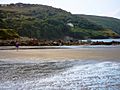
The rocky western end of the beach
-
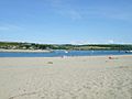
The beach in mid-summer
-

The edge of the dunes
-

The Poppit Rocket bus in Cardigan
-
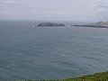
A view of Cardigan Island from Cemaes Head, above Poppit Sands


