
Cemaes Head facts for kids

Cemaes Head (pronounced Kem-ice) is a stunning headland and a special nature reserve in north Pembrokeshire, Wales. It's also known by its Welsh names, Pen Cemaes or Trwyn Cemaes. This amazing place is part of the Pembrokeshire Coast National Park. If you look west or north from Cemaes Head, you'll see the wide Cardigan Bay. To the east, you can spot Cardigan Island and where the River Teifi meets the sea.
Contents
Amazing Cliffs and Rocks


Cemaes Head might look calm from a distance, but its cliffs are truly impressive! On the north-western side, they reach over 175 meters (575 feet) high. These are the tallest cliffs in all of Pembrokeshire. Because they are so high, the small bays below are very hard to reach.
The rocks here are incredibly old, about 470 million years old! They are mostly made of sedimentary rocks like black mudstone. These rocks are severely twisted and bent, which you can easily see from the cliff tops or even better from the sea. Because these rocks are soft, the sea constantly wears them away. This means the cliffs are not safe for climbing.
In 1840, a writer named George Nicholson described Cemaes Head as "a promontory of immense elevation," meaning a very tall piece of land sticking out into the sea. The highest point of the headland is called Pengarn, reaching 189 meters (620 feet).
At the bottom of the cliffs on the western side, there's a stony beach called Traeth Godir Coch. You can only see this beach when the tide is low. The western side of Cemaes Head faces the full power of the Atlantic storms, while the eastern side is more sheltered.
The whole area of Cemaes Head has a unique look. You won't see many trees or hedges. The fields are separated by stony banks, and there aren't many modern buildings.
A Special Nature Reserve

Most of Cemaes Head is covered in fields where animals graze. But a big part of it is a protected nature reserve called Cemaes Head Nature Reserve. It covers about 20 hectares (nearly 50 acres). This area is also a Marine Special Area of Conservation (SAC) and a Site of Special Scientific Interest (SSSI), which means it's very important for nature.
Since 1984, the Wildlife Trust of South and West Wales has owned and looked after this reserve. They bought it with help from several groups, including the World Wide Fund for Nature. It was the 50th nature reserve the Trust had acquired!
Amazing Wildlife
Cemaes Head is a fantastic place to spot all sorts of wildlife.
Birds
You can often see birds like choughs (which have bright red beaks and legs), ravens, kestrels, and buzzards flying overhead. The tall sea cliffs are perfect nesting spots for many seabirds, including herring gulls, shags, fulmars, cormorants, razorbills, and guillemots.
Sea Animals
Look down at the foot of the cliffs or in the bay, and you'll often see grey seals. More grey seals have their babies here than anywhere else in Wales, starting in mid-summer! The waters around Cemaes Head are also home to bottlenose dolphins and porpoises. You can often see them swimming offshore.
Land Animals and Plants
The grassy slopes on the western side of the headland are grazed by ponies and rabbits. Welsh Mountain ponies were brought back here to help control the bracken (a type of fern), which encourages choughs to breed. This area is also home to small animals like voles.
Higher up, you'll find different types of maritime heather, such as ling heather and bell heather, along with gorse. On the more sheltered eastern slopes, bracken and wild flowers grow commonly. People are working to manage the bracken and to remove a plant called Himalayan Balsam, which can take over native plants.
Exploring Cemaes Head
Cemaes Head is located on the Pembrokeshire Coast Path, which is 186 miles long. This path is also part of the even longer Wales Coast Path, which stretches for 870 miles! The section of the path over Cemaes Head, from Poppit Sands to Ceibwr Bay, is about 5.5 miles long and has many ups and downs.
All the stiles and gates on the Pembrokeshire Coast Path are numbered from north to south. The very first stile on Cemaes Head has the number 1!
You can drive part of the way up Cemaes Head from Poppit Sands. The lane leads to a campsite called Allt y Coed, where you can park your car. From there, you can walk a two-mile loop around the headland on public paths. Another option is to park at the hamlet of Cippin, about a mile up the lane from Poppit Sands.
Both Cippin and Poppit Sands are stops for the Poppit Rocket, a bus service that runs along the coast during certain times of the year.
The Old Coastguard Lookout

High on the cliff top, above Traeth Godir Coch beach, you'll find an old coastguard lookout post. This building was first built in the 1800s. During World War II, it was made bigger with a new section facing the sea. This was one of many lookout posts along the coast that watched for enemy aircraft and submarines. The oil storage tanks at Milford Haven were a short flight away and were heavily bombed during the war.
After the war, this lookout post was no longer used. A new one was set up across the estuary at Gwbert.
History of Cemais
Cemaes Head sits on the northern edge of an old area called Cantref Cemais. This was a barony (a type of land ruled by a lord) during the Middle Ages. It was one of the "Seven Cantrefs of Dyfed".
Cantref Cemais covered the coastal area between the Teifi estuary and Fishguard, and the slopes of the Preseli Hills. It was about 359 square kilometers in size. Robert fitz Martin, a Norman knight, became the first Lord of Cemais and founded St Dogmaels Abbey nearby.
Even though the Normans took control in the 12th century, the people living here continued to speak Welsh. Later, this area became known as the Hundred of Cemais.
What Does "Cemaes" Mean?
The word 'cemais' comes from an old Welsh word, 'camas', which means a "bend or loop in a river" or sometimes a "bay or inlet of the sea." This name is quite common in Wales. For example, there's a village called Cemaes on Anglesey island, which is on a bay and a river bend.
Some people thought 'cemais' might mean "high field" or "field of feats," but experts now believe it refers to a bend. In the case of Cemaes Head, it likely refers to the angle where the coastline meets the mouth of the Teifi River.
The Welsh name Pen Cemaes (pen means head) has been used since the early 1800s. More recently, the name Trwyn Cemaes (trwyn means nose) has also been used by the Welsh Government and sea authorities.
There was no town or village called Cemaes here, only the larger area known as the Cantref. The name Cemaes Head probably comes from this ancient Cantref, as the headland itself wasn't a famous place in medieval times.
Images for kids
-
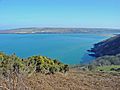
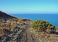
The coastal path on Cemaes Head, looking towards Cardigan Island
-
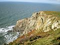
The cliffs viewed from the coastal path
-
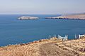
The Teifi Estuary from Cemaes Head
-
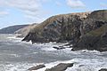
Looking towards Cemaes Head from Ceibwr Bay to the south. The contorted strata is evident.
-
The coastal path on Cemaes Head
-
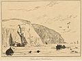
A drawing of 'Kemaes Head' as viewed from the sea, by William Daniell, 1815


