
Gwbert facts for kids
Quick facts for kids Gwbert |
|
|---|---|
 The shore by Coronation Drive, Gwbert, Ceredigion |
|

Gwbert
|
|
| OS grid reference | SN175465 |
| Community |
|
| Principal area | |
| Ceremonial county | |
| Country | Wales |
| Sovereign state | United Kingdom |
| Post town | CARDIGAN |
| Postcode district | SA43 |
| Dialling code | 01239 |
| Police | Dyfed-Powys |
| Fire | Mid and West Wales |
| Ambulance | Welsh |
| EU Parliament | Wales |
| UK Parliament |
|
| Welsh Assembly |
|
Gwbert (pronounced Goo-bert), also known as Gwbert-on-Sea, is a small village on top of cliffs in Ceredigion, Wales. It's right on the coast, at the very southern tip of Ceredigion. From Gwbert, you can see amazing views across Cardigan Bay and towards Poppit Sands and Cemaes Head in Pembrokeshire. You can get to Gwbert by road from the town of Cardigan, which is about 2.8 miles (4.5 km) away.
Contents
Discovering Gwbert's Past
Gwbert as we know it today mostly started in the early 1900s. The biggest buildings here are the Cliff Hotel and the smaller Gwbert Hotel. This village has an interesting story because it was meant to become a huge holiday resort, but it didn't quite happen. Even so, it's still a popular place for holidays. It's easy to get to the beautiful coastlines of Ceredigion and Pembrokeshire from here, which are full of stunning views and amazing wildlife.
The Ceredigion Coast Path is a long walking trail, about 60 miles (97 km) long. It's also part of the Wales Coast Path. This path goes through Gwbert, but it takes a small detour away from the cliffs north of the Cliff Hotel to keep walkers safe.
Where Did the Name Gwbert Come From?
Before people started living here in the late 1800s, this area was often called The Gwbert.
The name Gwbert probably comes from an old Celtic saint, Saint Cubert. This suggests there might have been a small chapel here a long time ago. Legend says that Gwbert, a traveling saint, landed here and found shelter in a cave. Gwbert is one of five saints honored in churches near the mouth of the River Teifi. These saints are also honored in churches close to each other in mid-Cornwall and in Brittany.
Even though the name Gwbert isn't found in old records as a village, Towyn Farm, which is on the edge of the nearby sand dunes, was mentioned in medieval times. It was a gentry house or settlement owned by Gwilym ap Einon in 1326. He was the constable of Cardigan Castle.
The name "Pant-y-Gilbert" appeared on maps in 1697. Both "Pant-y-Gilbert" and "Gwbert" were used by 1748. An 1838 map even spelled it "Goobert."
Who Lives in Gwbert?
In 1833, the whole Ferwig parish, which includes Gwbert, had 439 people. By 1851, there were 378 people.
In 2001, the wider area of Y Ferwig had a population of 1,177. Gwbert is only a small part of this area.
- Most people (63.1%) could speak, read, or write Welsh.
- Many residents were older, with 31.4% aged 45–64 and 22.17% aged 65 or older.
- The average age of everyone was 44.3 years.
Gwbert and Ferwig are only about a mile apart, but they are quite different! Ferwig is an old farming area where people's lives haven't changed much. Gwbert, however, is much newer, only about 120 years old, and has a mix of people. Since it started, many people with good incomes have moved here, both permanently and for holidays.
The lively tourist spots and sports facilities bring in many visitors. The number of people in Gwbert more than doubles during much of the year because of the caravan park and hotels. Also, international staff work in the hotels, adding to the village's diverse community. English is the main language spoken here.
Today, Gwbert has about 60 homes, mostly on Coronation Drive, Towyn Farm, and Evelyn Terrace. Many of these homes are rented out for holidays. There are also about 70 holiday caravans at the Patch Caravan Park, which are used from March to October. The two main hotels have almost 100 bedrooms combined.
Jobs in Gwbert are mainly at the Cliff Hotel, the Gwbert Hotel, Cardigan Golf Club, and Cardigan Island Farm Park. Many workers travel from nearby places like Cardigan, which also offers jobs for Gwbert's small working population.
What Can You Do in Gwbert?


Gwbert doesn't have its own shops, churches, or schools. The closest churches are in Y Ferwig, about 1.5 miles (2.4 km) away. These churches were built before Gwbert even existed. For shops and schools, people go to Cardigan.
The area of Towyn Burrows, which is next to Gwbert, is now home to the Cardigan Golf Club.
There's a very limited bus service that mostly goes to and from Cardigan. The nearest train station is in Fishguard, about 20 miles (32 km) away, because Cardigan's station closed in 1963.
Even with hotels, a caravan park, and a boatyard nearby, tourism hasn't changed the natural look of the area too much.
How Gwbert Was Promoted as a Holiday Spot
In the 1880s, the small inn in Gwbert was called the "Gwbert Watering Hole." In 1886, people first suggested that Gwbert should become a big seaside resort, hoping it would be as popular as Brighton or Scarborough! This idea came after a railway line opened to nearby Cardigan.
In 1888, the local council discussed building new holiday villas. By 1889, the local newspaper was calling Gwbert "Cardigan's 'New Brighton'." A businessman named Mr. C.E.D. Morgan-Richardson led a company to develop the old Gwbert Inn. They bought 96 acres of land and planned to build a row of boarding houses along what is now Evelyn's Terrace.
In July 1889, the local paper wrote about Gwbert: "Surrounded on two sides by the sea, its rocky boundaries are fringed by golden sands... the magnificent scenery... form a picture not easily rivalled." There was even talk of building a landing pier for boats.
A journalist named Ebenezer Rees wrote in 1894 that Gwbert was "Cardigan's famous and favourite watering place."
In 1897, a new road was built to Gwbert to make the area more accessible. This road first went from the Cliff Hotel to Patch. It took many years for it to reach its planned destination. Parts of the old road are still visible today. Some ancient stones from the Preseli Hills were used as gateposts along the old road.
Kelly's Directory of South Wales (1895) said: "Gwbert, a small place on the coast... is now rising into favour as a watering place." The Cardigan & Tivyside Golf Club also opened that year.
In The Rivers of Great Britain (1897), Charles Edwardes described Gwbert as "a distinctly primitive and pleasing watering-place."
E.R.H. Turner wrote in Walks and Wanderings in County Cardigan (1902) that Gwbert was "a spot on the coast marked by a hotel and a few villas, but sufficiently near to Cardigan to be a favourite pleasure resort." He added that it had "many nooks for bathing."
The local newspaper kept reporting on Gwbert's progress as a residential area in 1903 and 1906. In 1910, it even had an article titled "Gwbert on Sea, where is it and what is it?"
The Encyclopædia Britannica of 1911 also noted Gwbert's growth, saying it was one of several "small watering-places" that had sprung up.
However, despite big plans and lots of promotion, Gwbert never became a huge resort. It didn't have enough places to stay or enough facilities. It remained a small holiday spot.
In 1911, Gwbert held big celebrations for King George V's Coronation.
The Cliff Hotel's Story
A key part of the Gwbert development plan was to expand the old Gwbert Inn. It reopened in July 1890, with Mrs. Evelyn Morgan-Richardson, the developer's wife, officially opening it. She received a "massive silver key" as a gift! The inn became known as the Gwbert Hotel. A promotional book from 1907 said it was "An ideal spot for those who seek complete rest, bracing air, and country life." However, in May 1906, the hotel was completely destroyed by fire.
After being rebuilt and made much bigger, it reopened in April 1909 as the new Cliff Hotel. The name "Gwbert Hotel" was later used by another hotel. Golf links were added to attract more visitors. Early postcards from the hotel even quoted the Bishop of Bangor saying, "This is one of the most charming spots I ever visited."
The Cliff Hotel was sold to new owners in 1913. More recently, it has been expanded and updated with more rooms, a spa, and a leisure complex.
Exploring the Coastline
The coast around Gwbert is part of the Ceredigion Heritage Coast. This is a special protected area that stretches north from Gwbert to Aberystwyth. It's also a Special Area of Conservation, meaning it's important for nature.
The Ceredigion Coast Path goes through Patch and Gwbert, heading towards Mwnt. However, it doesn't follow the very edge of the cliffs here. The official path goes inland to Y Ferwig, then north to the coast at Mwnt. There's another possible route that goes closer to the coast from Cardigan Island Farm Park, but it's currently debated because some parts of the cliff path are said to be dangerous. South of Gwbert, at St Dogmaels, the Coast Path connects to the Pembrokeshire Coast Path.
The sandy area of Towyn Burrows, which is a big part of Gwbert, was formed by strong winds after the last ice age. These winds left behind sand and gravel from the Irish Sea, which now form the large sand dunes.
Gwbert beach (at Patch, south of the village) is the closest beach to Cardigan. It faces southwest and is sandy. Even though it was promoted a lot in the early 1900s, the tide here can change the beach shape a lot, and swimming can be dangerous. It's more known for sailing, sea-fishing, and extreme sports than for family swimming.
Even though Gwbert village is on top of cliffs, you can get down to the sea near Craig-y-Gwbert, below the Cliff Hotel. Steps cut into the rock lead to Cowley beach and a small, enclosed bay nearby. There are also accessible beaches below the Cliff Hotel with steps leading down to one beach, known as Evelyn's Beach. Another sandy cove is called Morgan's Beach. Below the hotel, you'll find Flat Rock and The Point.
In 1977, people worried about the cliffs eroding between Cardigan and Gwbert, especially at Patch. The road was only 45 feet (14 m) from the edge of the crumbling cliffs. In the early 1990s, after more erosion, six rock mounds called groynes were built to protect the coast. This project cost a lot of money, with half of it coming from the European Regional Development Fund.
The coastline around Gwbert is very rugged, especially north of Patch headland. In 1922, a fishing boat called the Princess Mary was lost here. Ten years later, in 1934, a large ship called the Herefordshire ran aground on Cardigan Island while being towed to be broken up. The four men on board were saved using rocket life-saving equipment kept at Gwbert.
Today, there's a Coastguard lookout post on the cliff edge. The original station started in 1878 and was staffed by local volunteers. They had equipment like ropes, lifebelts, rockets, and buoys, carried in a horse-drawn wagon. Today, an RNLI lifeboat operates from nearby Poppit Sands, which you can see across the river mouth from Gwbert.
Teifi Boating Club is based at The Patch, Gwbert, on the road towards Cardigan.
Amazing Wildlife in Gwbert
The coastal area around Gwbert is home to a huge variety of sea creatures, birds, butterflies, and wild flowers.
You can often spot Bottlenose dolphins and porpoises swimming in the bay. Grey seals from the nearby Cardigan Island colony are also frequently seen. Cardigan Bay has over 100 bottlenose dolphins living there, and sometimes even more! This is Europe's largest group of bottlenose dolphins.
Seals also live in the caves below Gwbert's Cardigan Island Coastal Farm Park. You can often see them resting on the rocks, especially on Carreg Lydan (which means Wide Rock).
In recent years, people have even seen basking sharks, sun fish, and even orcas, minke and humpback whales visiting the area. In September 1979, a 24-foot (7.3 m) whale was found dead on the rocks near Clunyrynys Farm, Gwbert. A scientist found a rare 15-spined sea stickleback eating it!
Choughs, which are black birds with red beaks, live in holes in the cliffs. The coast at Gwbert is also home to many other birds like gannets, razorbills, guillemots, Manx shearwaters, black-headed gulls, and fulmars. On land, you might see birds of prey like red kites, buzzards, peregrine falcons, kestrels, and sparrowhawks. Skylarks are also a common sight.
When the tide is low, you can see many different wading birds in the river mouth.
During the summer months (June to September), hundreds of Canada geese fly north over Gwbert every day towards the Dyfi estuary marshes, returning each evening. These geese live in the Teifi river mouth and valley. They also graze on Cardigan Island. The pond at Gwbert's Cardigan Island Farm Park also attracts geese, and sometimes over 100 Canada geese gather there. Wild shelducks, teal, and mallard also nest at the farm.
You can take boat trips to see the amazing wildlife off the Gwbert coast. These trips leave from the Teifi Boating Club jetty at Gwbert, as well as from Poppit Sands and Cardigan.
Gwbert's Weather
Just like the rest of the British Isles, Gwbert has a maritime climate. This means it has cool summers and mild winters. The closest official weather station that keeps records is at Aberporth, which is about 5.7 miles (9.2 km) east-northeast of Gwbert and has similar coastal weather.
Usually, less than three days a year will reach 25.1°C (77.2°F) or hotter. The warmest day should reach about 26.8°C (80.2°F). The highest temperature ever recorded was 32.7°C (90.9°F) in July 2006. On average, there will be frost in the air on 18.3 nights, and the coldest night of the year should drop to about -4.5°C (23.9°F). The lowest temperature ever recorded was -9.9°C (14.2°F) in January 1963.
Gwbert gets about 870 mm (34.3 inches) of rain each year, with at least 1 mm (0.04 inches) falling on about 143.5 days.
| Climate data for Aberporth Weather Station (5.7 miles ENE of Gwbert) at 133 m asl, 1971–2000, Extremes 1960–present | |||||||||||||
|---|---|---|---|---|---|---|---|---|---|---|---|---|---|
| Month | Jan | Feb | Mar | Apr | May | Jun | Jul | Aug | Sep | Oct | Nov | Dec | Year |
| Record high °C (°F) | 13.4 (56.1) |
15.2 (59.4) |
21.0 (69.8) |
25.6 (78.1) |
26.6 (79.9) |
31.5 (88.7) |
32.7 (90.9) |
31.5 (88.7) |
25.2 (77.4) |
22.0 (71.6) |
17.0 (62.6) |
14.1 (57.4) |
32.7 (90.9) |
| Mean daily maximum °C (°F) | 7.3 (45.1) |
7.3 (45.1) |
8.7 (47.7) |
10.6 (51.1) |
13.7 (56.7) |
15.9 (60.6) |
18.0 (64.4) |
18.1 (64.6) |
16.1 (61.0) |
13.2 (55.8) |
10.0 (50.0) |
8.3 (46.9) |
12.3 (54.1) |
| Mean daily minimum °C (°F) | 2.9 (37.2) |
2.6 (36.7) |
3.8 (38.8) |
4.9 (40.8) |
7.5 (45.5) |
10.0 (50.0) |
12.2 (54.0) |
12.3 (54.1) |
10.7 (51.3) |
8.4 (47.1) |
5.6 (42.1) |
3.9 (39.0) |
7.1 (44.8) |
| Record low °C (°F) | −9.9 (14.2) |
−7.5 (18.5) |
−6.6 (20.1) |
−2.0 (28.4) |
0.1 (32.2) |
1.7 (35.1) |
5.6 (42.1) |
5.5 (41.9) |
3.3 (37.9) |
−0.9 (30.4) |
−5.0 (23.0) |
−6.0 (21.2) |
−9.9 (14.2) |
| Average precipitation mm (inches) | 88.5 (3.48) |
62.7 (2.47) |
63.7 (2.51) |
50.7 (2.00) |
48.2 (1.90) |
61.1 (2.41) |
49.2 (1.94) |
68.2 (2.69) |
75.7 (2.98) |
104.2 (4.10) |
98.3 (3.87) |
99.2 (3.91) |
870.2 (34.26) |
| Mean monthly sunshine hours | 54.6 | 74.0 | 109.7 | 168.6 | 213.6 | 190.5 | 198.7 | 184.8 | 141.0 | 100.1 | 63.3 | 45.6 | 1,544.5 |
| Source: Met Office | |||||||||||||
Ancient Discoveries and Famous People
Craig y Gwbert, on the cliff edge near the Cliff Hotel, has the remains of an Iron Age fort. This fort was well-protected, but no old farm fields have been found nearby. You can only reach it through a narrow strip of land, and it was defended by a large earth bank, about 2.5 meters (8 feet) high and 40 meters (131 feet) long. The entrance was a small gap in this bank. Today, you can see remains of old lime pits and a lime kiln here. The Cliff Hotel's nine-hole golf course also uses this area.
In the mid-1970s, an old medieval rubbish pit was found in the eroding cliff at Coronation Drive, south-west of Gwbert. It was covered in sand and was about 3 meters (10 feet) wide and 1.5 meters (5 feet) deep. Inside, archaeologists found some medieval leather shoes and 75 pieces of pottery. This pottery is now known as "Gwbert Ware" and is a type of pottery from the 13th century. You can see examples of these pieces at the Cardigan Heritage Centre. Other things found in the pit included animal bones and a stone axe. They also found signs of old ploughed soil and cattle hoof prints under the sand.
Notable Residents: Caleb Morris
The Reverend Caleb Morris (1800–1865) was born in Pembrokeshire and studied in Cardigan. He moved to London in 1838 and became a minister. He was known as a very good and powerful speaker and was one of the most important preachers in London. When he felt unwell, he would return to Wales to get better. He had to retire early because of his health. He spent the last year of his life in Gwbert, where he passed away at a place called The Lodge on July 26, 1865.
Images for kids
-
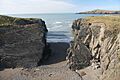
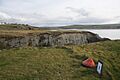
The coastline by Craig y Gwbert
-
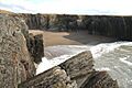
A sandy cove near Gwbert
-
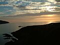
A sunset from Gwbert
-
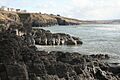
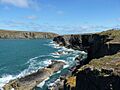
Gwbert's rocky coastline
-
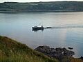
Fishing boat off Gwbert
-
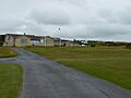
The golf-course clubhouse at Gwbert
-
The 8th hole on Craig y Gwbert
-
The coastline at Gwbert, looking towards Cardigan Island


