Aberporth facts for kids
Quick facts for kids Aberporth |
|
|---|---|
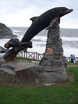
 Leaping Dolphin sculpture,in Aberporth |
|
| Population | 2,374 (2011) |
| OS grid reference | SN2549251448 |
| Principal area | |
| Ceremonial county | |
| Country | Wales |
| Sovereign state | United Kingdom |
| Post town | Cardigan |
| Postcode district | SA43 2 |
| Police | Dyfed-Powys |
| Fire | Mid and West Wales |
| Ambulance | Welsh |
| EU Parliament | Wales |
| UK Parliament |
|
| Welsh Assembly |
|
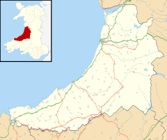
Aberporth is a charming seaside village and community in Ceredigion, Wales. In 2011, about 2,374 people lived in the wider community, and 1,241 in the village itself. Aberporth is famous for its beautiful beaches, which have earned special "Blue Flag" status for being clean and safe.
Contents
Where is Aberporth Located?
Aberporth is found along the Ceredigion Coast Path, which is part of the longer Wales Coast Path. It sits at the southern end of Cardigan Bay. The village is about 6 miles (10 km) northeast of Cardigan and 10 miles (16 km) southwest of New Quay. You can reach Aberporth easily from the main A487 road by taking the B4333 road for about 2 miles (3 km).
What Does the Name Aberporth Mean?
The name Aberporth was first written down in 1284. It comes from two old Welsh words: "aber," meaning "mouth," and "porth," meaning "port." So, Aberporth means "mouth of the port."
A Look Back at Aberporth's History
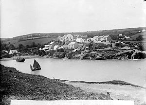
In the 1500s, Aberporth was a small port where boats brought in things like nets and salt from Ireland. These items were important for preserving food. The village grew quickly in the late 1600s and early 1700s as more local people started trading by sea.
It became a very busy port. The northern beach stretched into the river valley, creating a safe place for ships to anchor. Buildings like Lime kilns, coal yards, and warehouses were built along the south shore.
Aberporth also became a major center for herring fishing in Wales. Fishermen used different methods like drifting and netting. At one point, at least 20 special fishing boats called "smacks" went out regularly to catch herring. This fishing industry lasted until the start of the First World War, when there were fewer fish to catch.
How Aberporth is Governed
Aberporth is an electoral ward, which means it's an area that elects one person to represent it on the Ceredigion County Council. This person helps make decisions for the local area. The village also has a local group called Aberporth Community Council, made up of 12 community councillors. They look after local matters in the village.
Things to Do and See in Aberporth
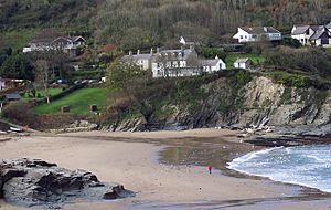
Aberporth has two lovely sandy beaches: Traeth y Dyffryn (which means "valley beach") and Traeth Dolwen. Both of these beaches have won the "Blue Flag" award many times. This award means they are clean, safe, and well-managed.
In the summer, Aberporth is a popular spot for recreational fishing. It's also a great place for divers and people who enjoy boating. Some local people still catch crabs and lobsters on a small scale.
Sometimes, you might even spot amazing sea creatures offshore! Bottle nose dolphins are often seen near the Ministry of Defence site from April onwards. While rare, orcas, harbour porpoises, turtles, sunfish, and basking sharks have also been seen in the waters off Aberporth.
Besides tourism, a big employer in the area is the Ministry of Defence's missile range, run by Qinetiq. There's also ParcAberporth, a technology park. This park is home to companies that work on defence, aerospace, and UAVs, which are also known as drones. ParcAberporth works closely with researchers at Aberystwyth University.
Aberporth Airport (EGFA) is being developed as West Wales Airport. It's used for domestic flights and is becoming a key place for testing and using both civilian and military drones. The airport's runway was made longer in 2008, growing from 945 meters to 1257 meters.
Education in Aberporth
Aberporth School first opened in 1834. In 1854, a new building was built for 110 students. For a long time, it was a "national school" that taught children according to the Church of England's beliefs.
Today, the main school in Aberporth is Ysgol Gymunedol Aberporth, a primary school. In 2013, there were 122 students. The school now teaches mainly in Welsh, helping to keep the language strong.
Famous People from Aberporth
Aberporth is proud to be the home of four Welsh Rugby international players, and one of them even played for the British and Irish Lions!
- Ricky Evans (born 1960) was born in Aberporth and played for Wales.
- Wayne Proctor (born 1972) grew up in Aberporth and also played for Wales.
- Paul Ringer (born 1948) was raised in Aberporth and played for Wales.
- Brynmor Williams (born 1951) grew up in Aberporth and played for both Wales and the British and Irish Lions.
Aberporth Weather Station
The Met Office, which is the UK's national weather service, has a weather station in Aberporth. This station collects important weather information. Its reports are even included in the Shipping Forecast on BBC Radio, which helps ships at sea. Weather records for Aberporth go all the way back to 1941.
Usually, the temperature in Aberporth only reaches 25.1°C (77.2°F) or higher on fewer than three days a year. The warmest day on average is about 26.8°C (80.2°F). The hottest temperature ever recorded in Aberporth was 32.7°C (90.9°F) in July 2006.
On average, there are about 15 nights a year when the temperature drops below freezing. The coldest night of the year usually reaches about -5.9°C (21.4°F). The lowest temperature ever recorded was -9.9°C (14.2°F) in January 1963.
Aberporth gets about 931 millimeters (36.7 inches) of rain each year. It rains at least 1 millimeter (0.04 inches) on about 151 or 152 days a year.
| Climate data for Aberporth 133m asl, 1991-2020, Extremes 1960- | |||||||||||||
|---|---|---|---|---|---|---|---|---|---|---|---|---|---|
| Month | Jan | Feb | Mar | Apr | May | Jun | Jul | Aug | Sep | Oct | Nov | Dec | Year |
| Record high °C (°F) | 13.4 (56.1) |
15.2 (59.4) |
21.0 (69.8) |
25.6 (78.1) |
26.6 (79.9) |
31.5 (88.7) |
32.7 (90.9) |
31.5 (88.7) |
25.2 (77.4) |
22.0 (71.6) |
17.0 (62.6) |
14.1 (57.4) |
32.7 (90.9) |
| Mean daily maximum °C (°F) | 7.7 (45.9) |
7.9 (46.2) |
9.5 (49.1) |
11.6 (52.9) |
14.4 (57.9) |
16.7 (62.1) |
18.3 (64.9) |
18.2 (64.8) |
16.6 (61.9) |
13.5 (56.3) |
10.5 (50.9) |
8.4 (47.1) |
12.8 (55.0) |
| Mean daily minimum °C (°F) | 3.4 (38.1) |
3.3 (37.9) |
4.3 (39.7) |
5.8 (42.4) |
8.2 (46.8) |
10.7 (51.3) |
12.5 (54.5) |
12.7 (54.9) |
11.3 (52.3) |
8.9 (48.0) |
6.2 (43.2) |
4.1 (39.4) |
7.1 (44.8) |
| Record low °C (°F) | −9.9 (14.2) |
−7.5 (18.5) |
−6.6 (20.1) |
−2.0 (28.4) |
0.1 (32.2) |
1.7 (35.1) |
5.6 (42.1) |
5.5 (41.9) |
3.3 (37.9) |
−0.9 (30.4) |
−5.0 (23.0) |
−6.0 (21.2) |
−9.9 (14.2) |
| Average precipitation mm (inches) | 90.2 (3.55) |
66.9 (2.63) |
57.4 (2.26) |
54.2 (2.13) |
54.7 (2.15) |
64.3 (2.53) |
66.5 (2.62) |
75.4 (2.97) |
70.5 (2.78) |
107.9 (4.25) |
116.7 (4.59) |
106.4 (4.19) |
931.1 (36.65) |
| Average rainy days | 15.3 | 11.7 | 11.2 | 11.2 | 10.2 | 9.6 | 10.7 | 11.6 | 12.0 | 15.0 | 17.0 | 16.2 | 151.7 |
| Mean monthly sunshine hours | 60.2 | 79.2 | 127.6 | 174.4 | 211.6 | 203.8 | 188.8 | 169.3 | 142.0 | 99.8 | 59.6 | 49.5 | 1,565.8 |
| Source 1: Met Office | |||||||||||||
| Source 2: Meteoclimat | |||||||||||||
See also
 In Spanish: Aberporth para niños
 | Misty Copeland |
 | Raven Wilkinson |
 | Debra Austin |
 | Aesha Ash |


