Landsker Line facts for kids
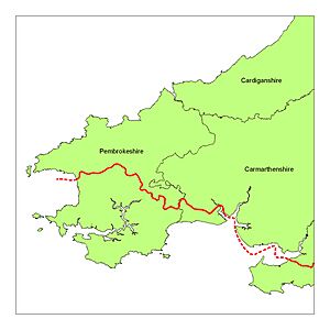
The Landsker Line is a special invisible border in Wales. It separates areas where people mostly speak Welsh from areas where people mostly speak English. This line runs through Pembrokeshire and Carmarthenshire. South of the Landsker Line, the English-speaking area is sometimes called Little England beyond Wales. It's interesting because this area has been English-speaking and culturally English for hundreds of years, even though it's far from the main border with England.
Contents
A Look Back in Time
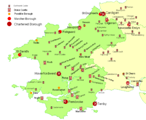
During the 11th and 12th centuries, many castles were built along this line. Both invaders and defenders built over fifty castles to protect their areas. Some of these castles included Laugharne, Wiston, Camrose, Narberth, and Roch. These castles were important for controlling the land.
The Landsker Line hasn't always stayed in the same place. Sometimes it moved north into the Mynydd Preseli during wars. Other times, in more peaceful periods, it moved south again. This happened as English settlers found it hard to farm on the cold, hilly land in the north.
The word "landsker" was used a long time ago by people like George Owen of Henllys in 1603 and Richard Fenton in 1810. Even today, people might not know the term "Landsker," but they can still see the clear language difference from St Bride's Bay to Carmarthen Bay.
Language and People's DNA
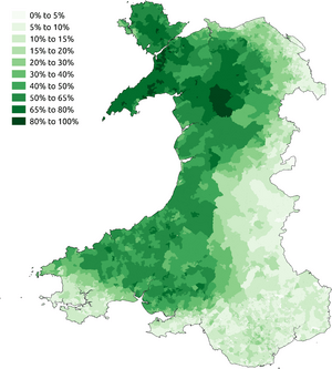
The difference in how many people speak Welsh is still clear today. You can see this on maps made from the 2011 census.
Scientists have also found interesting differences in people's DNA. In 2015, researchers found "surprisingly clear differences" in the DNA of people living north and south of the Landsker Line in Pembrokeshire.
What "Landsker" Means
The word "Landsker" comes from an old Anglo-Saxon word. It means a clear, lasting boundary between two areas of land. This boundary could be something natural, like a river, or something man-made, like a hedge. In Wales, the official use of the word stopped around the late 1700s.
However, in 1939, the term "Landsker" started to be used for the language border in southwest Wales. Even though a language boundary isn't usually visible, the word "Landsker" is now commonly used to mean this language line.
A Lasting Cultural Border
The Landsker Line is a cultural border that has lasted for over a thousand years without any official legal status. To the north and east of the line, people speak Welsh. To the south and west, they speak English. The line starts at St Bride’s Bay and winds its way east until it reaches the River Taf near Laugharne in Carmarthenshire. You can also see traces of this border near Llansteffan and Kidwelly, and it's very clear in the Gower area. The area south of the line was called Anglia Transwalliana (Little England beyond Wales) in the 1500s.
In 1603, George Owen of Henllys wrote about the language boundary and "Little England beyond Wales." He shared the traditional idea that Norman invaders in the 1100s cleared the area of Welsh people and brought in Flemings (people from Flanders). However, Owen noted that by his time, there were no signs of Flemish customs or language. In fact, the English spoken in Pembrokeshire is similar to old English from southwest England. It's likely that the English language spread along the Welsh coast at the same time it spread in Devon and Cornwall. A DNA study in 2003 showed that people in 'Little England' are genetically very similar to people in southern England.
The Landsker Line was not just about language. There were also differences in customs, like how land was inherited, and in building styles. George Owen described the cultural border as very clear and stable in 1602. Later, others agreed that the line stayed much the same. However, a study in the 1960s showed that while the line was similar to Owen's description, it had moved a bit in some places. People living near the border didn't use the term "Landsker," but they knew exactly where the language change happened. The boundary isn't a sharp line, but more like a mixed language area, about 2 to 3 miles wide.
The border has moved over time. For example, between 1200 and 1600, it shifted. Some Norman/English "planned villages" were tried north of the current line in the Middle Ages, but they didn't last. Welsh speakers moved back into these areas after the Black Death. In more recent times, Welsh speakers spread south, especially in Carmarthenshire. However, in central Pembrokeshire, the Landsker Line actually moved south by over 6 miles between 1600 and 1900.
Southwest Wales has many Norman castles. Some are deep in Welsh-speaking areas (like Newport, Cardigan, Cilgerran, Newcastle Emlyn, Carmarthen). Others are deep in Little England (like Pembroke, Carew, Manorbier, Haverfordwest, Tenby). A few castles are very close to the language boundary, such as Roch, Wiston, Llawhaden, Narberth, and Laugharne. These are sometimes called "frontier castles."
The Landsker Line is known for being quite clear and for not moving much over many centuries. One visible feature that marks the Landsker Line is Brandy Brook, which runs through Newgale. The first beach north of this brook has the Welsh name Pen-y-Cwm.
 | Kyle Baker |
 | Joseph Yoakum |
 | Laura Wheeler Waring |
 | Henry Ossawa Tanner |


