
Caldey Island facts for kids
Quick facts for kids Caldey Island
|
|
|---|---|
 The south coast of Caldey Island |
|

Caldey Island
|
|
| Population | 40 (2011) |
| Principal area | |
| Ceremonial county | |
| Country | Wales |
| Sovereign state | United Kingdom |
| Post town | TENBY |
| Postcode district | SA70 |
| Dialling code | 01834 |
| Police | Dyfed-Powys |
| Fire | Mid and West Wales |
| Ambulance | Welsh |
| EU Parliament | Wales |
| Welsh Assembly |
|


Caldey Island (which is Ynys Bŷr in Welsh) is a small island near Tenby, Pembrokeshire, Wales. It's less than 1 mile (1.6 km) off the coast. This island has a long history, going back over 1,500 years, and is known as one of Britain's holy islands.
Today, Cistercian monks live on Caldey Island. They follow many old traditions that come from Celtic times. The monks own the island and live at Caldey Abbey.
About 40 people live on the island permanently, plus a changing number of Cistercian monks. These monks, also called Trappists, came from Belgium in the early 1900s. They took over from another group of monks who had built the monastery but faced money problems. Now, the monks of Caldey Abbey earn money from tourism and by making perfumes and chocolate.
You can usually get to the island by boat from Tenby, which is about 2.5 miles (4 km) north. In spring and summer, visitors come to Caldey to see the sacred places and enjoy the island's amazing wildlife. After getting rid of rats, red squirrels were brought to the island in 2016. Besides rare sheep and cattle, the island has many different birds and plants.
Contents
What's in a Name?
The Welsh name for the island, Ynys Bŷr, comes from Saint Pyr. He was a saint from the 6th century and was the abbot (leader) of the monastery around the year 500. This Welsh name has been used since the Middle Ages. We don't know what the island was called before Saint Pyr's time.
Like many Welsh islands, Caldey's English name (sometimes spelled Caldy) comes from the Vikings. Kald ey means "cold island" in their language. The name 'Caldea' appeared in the early 1100s, and 'Kaldey' or 'Caldey' by 1291.
Island History
Ancient Times

Scientists have found three caves on Caldey Island: Nanna's Cave, Potter's Cave, and Ogof–yr-Ychen (which means "Ox cave"). These caves have given us clues about people who lived here long ago.
In Nanna's Cave, human bones and shells were first found in 1911. More digging happened until the 1970s. Potter's Cave was found in 1950 by a monk. Inside, they found tools and animal remains stuck in rock formations. Later, three human skeletons were found. Two were from the Middle Stone Age (a very old time), and one was from the Roman-British period. Some older tools from the late Upper Paleolithic period were also found.
In Ogof–yr-Ychen, bones of people who lived between 7590 BC and 5710 BC were discovered. Tests showed that these ancient people ate a lot of seafood. A few very old bowls and shells have also been found in the caves. All these amazing finds are kept at Caldey Abbey or in the Tenby Museum and Art Gallery.
Later History

A Celtic monastery was first built on the island in the 6th century. The island was very important during the Middle Ages. In the 12th century, Caldey Priory was started by a group of monks. This priory lasted until the 1530s, when many monasteries were closed down.
The current abbey was built in 1910 by Anglican Benedictine monks. However, they had money problems, and in 1929, Belgian Cistercians bought the property. The abbey is a great example of the Arts and Crafts movement style. It was the biggest project by an architect named John Coates Carter. The abbey has white walls, red roofs, and a unique tower.
Caldey Island and Little Caldey Island have been an important church area for a very long time. In 2007, about 20 Cistercian monks lived at the monastery.
Island Geography
Caldey Island is about 1.5 miles (2.4 km) long and 1 mile (1.6 km) wide at its widest point. It covers an area of about 538 acres (2.18 sq km). The highest point on the island is 197 feet (60 meters) above sea level.
The island is in Carmarthen Bay, on the northern side of the Bristol Channel. It's in the county of Pembrokeshire, a little over 2.5 miles (4 km) south of Tenby on the mainland. Caldey Sound separates the island from the mainland.
A ferry service runs from Tenby to Caldey Island in the spring and summer, when the weather is good. Boats leave every half hour from the harbor when the tide is high. When the tide is low, they leave from Castle Beach.
Caldey Island is actually two islands that separate at high tide: Caldey Island and Little Caldey Island. Little Caldey Island is also called St Margaret's Island. It's off the north-western tip of Caldey Island. It got its name in the 1600s and is famous for its seals and as a bird sanctuary. Most of the island is used for grazing animals.
Weather on Caldey Island
The weather on Caldey Island is shown in the table below. The hottest temperature ever recorded was 33°C (91°F) in August. The coldest was -9°C (16°F) in February.
| Climate data for Caldey Island, Wales | |||||||||||||
|---|---|---|---|---|---|---|---|---|---|---|---|---|---|
| Month | Jan | Feb | Mar | Apr | May | Jun | Jul | Aug | Sep | Oct | Nov | Dec | Year |
| Mean daily maximum °C (°F) | 8 (46) |
8 (46) |
10 (50) |
12 (54) |
15 (59) |
17 (63) |
20 (68) |
20 (68) |
17 (63) |
14 (57) |
11 (52) |
8 (46) |
20 (68) |
| Mean daily minimum °C (°F) | 3 (37) |
3 (37) |
5 (41) |
5 (41) |
8 (46) |
10 (50) |
13 (55) |
12 (54) |
10 (50) |
8 (46) |
5 (41) |
3 (37) |
3 (37) |
| Source: Weatherbase
Retrieved on 5 June 2013 |
|||||||||||||
Island Wildlife
Caldey Island is famous for its beautiful flowers. Many of these flowers are rare in other parts of the United Kingdom. The island also has many different kinds of birds, especially in the summer. The largest group of cormorants in the country lives on St Margaret's Island.
After a two-year program to remove rats, red squirrels were brought to the island in 2016. By 2018, they were successfully having babies and growing their population.
Island Life and Economy
The island's money comes from tourism and selling perfumes and chocolate made by the monks. Tourism is the biggest source of income. In 2001, the monastery even opened an online shop to sell their products. A famous perfume critic once said their lavender perfume was "simply the best lavender soliflore on earth"!
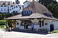
Caldey Island also offers a spiritual retreat where up to 750 guests can stay each year. The island has its own post office, which includes a museum about the island's history. They even have their own postage stamps and a special money unit named after a local fish, the dab. There's a tea shop on the green and an underground water tank near the lighthouse, which gets its water from a natural spring. This water is used for the gardens and by the people.
For emergencies, the island has a Land Rover that is shared by the Fire Service, Coastguard, and Police. There are two fire engines and a regular firefighting team. The monks used to do this job. The last big fire on the island was in 1940, when the monastery was damaged.
Cool Places to See

Some popular places to visit on Caldey Island include:
- The recently fixed 13th-century church of St Illtyd.
- An ogham cross from the 6th century, which is a stone with ancient carvings.
- A Norman chapel.
- Caldey Abbey, which was finished in 1910.
Caldey Lighthouse was built in 1828. Its light helped ships carrying limestone and coal to North Wales. It also helped bigger ships know they were entering the Bristol Channel and not the English Channel. The lighthouse is a short, round tower made of limestone, about 17 meters (56 feet) tall. Its walls are very thick. The light itself is 64 meters (210 feet) above the high-water mark. The lighthouse became automatic in 1929, meaning it didn't need a person to operate it anymore. The old building where oil for the lighthouse was stored is now a protected building. The lighthouse keeper's cottages next to the lighthouse were built around 1868–70.
The north side of Caldey Island has a lot of grey limestone, which is a good material for building. In the 1800s, a lot of limestone was dug up on the island. Some of it was taken to a place called Annery kiln in North Devon to be processed.
Images for kids
-
Caldey Post Office and Museum

