
Ramsey Island facts for kids
|
Native name:
Ynys Dewi
|
|
|---|---|

Ramsey Island viewed from St David's Head
|
|

Ramsey Island
Location in Wales
|
|
| Geography | |
| Location | St Brides Bay |
| Coordinates | 51°51′42″N 5°20′34″W / 51.86167°N 5.34278°W |
| Length | 3.2 km (1.99 mi) |
| Highest elevation | 136 m (446 ft) |
| Highest point | Carnllundain |
| Administration | |
|
Wales
|
|
| County | Pembrokeshire |
| Demographics | |
| Population | 2 |
| Ethnic groups | Welsh people |
Ramsey Island, known as Ynys Dewi in Welsh, is a beautiful island located off the coast of Pembrokeshire in southwest Wales. It's about 1 kilometer (0.6 miles) from St David's Head and sits on the northern side of St Brides Bay. The island covers an area of 259 hectares (640 acres). Its name, Ramsey, comes from Old Norse and means "Hrafn's island."
In Welsh, the island is named after Saint David (Dewi Sant), who is the patron saint of Wales. Long ago, it was home to his trusted friend, Saint Justinian. The closest town to Ramsey Island is the city of St David's.
Ramsey Island is less than 3.2 kilometers (2 miles) long. Its highest point is a hill called Carnllundain, which reaches 136 meters (446 feet) above sea level. This makes it the fourth largest island in Wales, after Anglesey, Holy Island, and Skomer. Many smaller islands and rocks surround Ramsey Island.
Contents
What Is Ramsey Island Made Of? (Geology)
Ramsey Island has a very interesting geology, meaning it's made of many different kinds of rocks for its size. These rocks formed a very long time ago, during the early Palaeozoic Era. You can find sedimentary rocks (like mudstone), volcanic rocks (from ancient volcanoes), and intrusive rocks (formed when magma pushed into other rocks and cooled).
Most of the northern part of the island is made of mudstones. However, a tougher rock called microtonalite forms a prominent hill called Carnysgubor. Along the coast, you can see sedimentary rocks like sandstones and more mudstones. These rock layers are often tilted steeply and have faults, which are cracks where the earth has moved.

In the middle of the island, there's a band of volcanic rocks called tuffs and 'pencil slates'. These formed from volcanic ash falls. The southern part of the island is mostly made of a volcanic rock called rhyolite. This rock also forms the small islands off the southern coast.
Who Lived on Ramsey Island Long Ago? (Archaeology)
Scientists have studied Ramsey Island and found signs that people lived there up to 5,000 years ago! They discovered old burial mounds called cairns, ancient farm fields, and other clues that show human activity.
During the Middle Ages, around the 9th century, there was a holy well and a cemetery on the island. This suggests it was an important spiritual place.
A Look Back in Time (Recorded History)
From the year 1082, Ramsey Island was part of an area called Dewisland, which was controlled by the bishops of St David's. In the 12th century, many people visited the island as a place of pilgrimage. There was a chapel dedicated to St Tyfanog, which was still there in the 1600s but later fell into ruin. There might have also been a chapel for St Justinian.
In the 13th century, people said the island was very fertile. It produced beef, sheep, goats, wheat, barley, and oats. By the 14th century, about 100 acres of the island were used to raise horses, cattle, and sheep. People also collected rabbits, rushes, and birds' eggs.
Later, in the 16th century, records show a farmhouse, a mill for grinding corn, and a kiln for making lime. The farmhouse became a ruin by the early 1800s. However, the mill and kiln kept working until the early 1900s. In 1905, the island was sold to private owners and was no longer owned by the church. A new farmhouse was built in the early 1800s, and it is now a protected historic building.
Ramsey Island: A Home for Wildlife (Nature Reserve)
Today, Ramsey Island is a special nature reserve. It is owned and looked after by the Royal Society for the Protection of Birds (RSPB). The island has amazing bird cliffs, beautiful coastal views, and open heathland.
It's one of the best places in Wales to see choughs. These smart birds with red beaks love to eat dung beetles, which are plentiful on the island.
Many other birds also breed here, including ravens, common buzzards, peregrines, northern wheatears, different types of gulls, and auks like Manx shearwaters, razorbills, and guillemots.
Ramsey Island is also super important for grey seals. It has the largest breeding colony for grey seals in southern Britain! Over 400 seal pups are born here every autumn. Sadly, in October 2017, a strong storm called Hurricane Ophelia caused the deaths of about 90 seal pups.
Only two people live permanently on the island: the RSPB Warden and their assistant. They live in the farmhouse and look after the island's wildlife. If you want to visit, tourist boats sail around the island, and a ferry service runs from Easter to October 31st from St Davids Lifeboat Station on the mainland.
Exploring Ramsey Sound

The waters around Ramsey Island, known as Ramsey Sound, have very strong tidal effects. This means the water moves in and out with a lot of force, creating "tidal waterfalls" where the water rushes over underwater rocks. The water can flow very fast, up to 3.8 meters per second (12.5 feet per second) when moving north!
The sound can be as deep as 66 meters (216 feet). There's also a rock called Horse Rock that sticks out of the water at low tide. This rock was named way back in 1583.
In 2015, a special project was started to use the strong tides to create electricity. A 400-kilowatt tidal power turbine was installed, with plans for more.
Ramsey Island is surrounded by several smaller islands and rock groups. Some of these include:
- The Bishops and Clerks group, which has several rocks like Emsger (also called South Bishop) and North Bishop.
- Meini Duon (meaning Black Rocks), which are three sea rocks south of Ramsey Island.
- Ynys Bery (meaning Falcon Island), which is 71 meters (233 feet) high.
- Ynys Cantwr (meaning Precentor's Island), a small island that is covered by water at high tide.
- Ynys Eilun and Pont yr Eilun, two small islands that are difficult to land on because of strong currents.
- Ynys Gwelltog (meaning Grassy Island), another tidal island that was once used to graze two sheep.
Images for kids
-
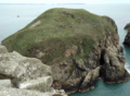
Ynys Cantwr seen from Ramsey Island
-
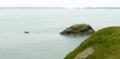
Ynys Eilun (right) and Pont yr Eilun (left), from Ynys Cantwr
-
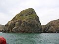
Ynys Gwelltog, viewed from the sea


See also
 In Spanish: Isla Ramsey para niños
