Moelwyn Mawr facts for kids
Quick facts for kids Moelwyn Mawr |
|
|---|---|

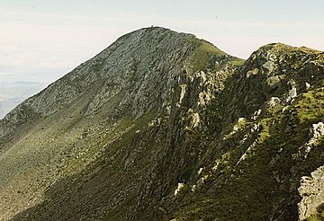
Moelwyn Mawr summit ridge
|
|
| Highest point | |
| Elevation | 770 m (2,530 ft) |
| Prominence | 385 m (1,263 ft) |
| Parent peak | Moel Siabod |
| Listing | Marilyn, Hewitt, Nuttall |
| Naming | |
| English translation | great white hill |
| Language of name | Welsh |
| Geography | |
| Location | Gwynedd, Wales |
| Parent range | Snowdonia |
| OS grid | SH658448 |
| Topo map | OS Landranger 124 |
Moelwyn Mawr is a tall mountain located in Snowdonia, North Wales. It is part of a group of mountains called the Moelwynion. From its top, you can see amazing views in every direction, including the beautiful Vale of Ffestiniog below.
Contents
A Special Place for Nature
Moelwyn Mawr is a very important place for nature. In 1990, it was named a Site of Special Scientific Interest. This means it has special features that scientists want to protect.
Traces of the Ice Age
The mountain's landscape shows clear signs of a time long ago when huge glaciers covered the land. These glaciers carved out the valleys and shaped the mountains we see today. You can still find interesting landforms left behind by the ice.
History of Quarrying
For many years, slate quarrying was a huge business in the Moelwynion mountains. Moelwyn Mawr has several large quarries on its sides.
Famous Quarries on Moelwyn Mawr
- To the west, high above Cwm Croesor, is Croesor Quarry.
- Further north-west, between Cwm Croesor and Cwm Orthin, you'll find Rhosydd Quarry.
- Inside Cwm Orthin, there are Conglog and Wrysgan quarries.
- To the east, in Cwm Ystradau, lies Moelwyn Slate Quarry.
These quarries show how important slate was to the local area's history.
Exploring Moelwyn Mawr
Moelwyn Mawr is a popular spot for walkers and adventurers. Climbing to the top offers incredible views that you can't see from anywhere else.
The Summit and Its Views
At the very top of Moelwyn Mawr, there is a trig point. This is a special marker used for surveying. From here, you can enjoy wide-open views of the surrounding mountains and valleys.
The Moelwyns Walk
Many hikers enjoy a walk that includes both Moelwyn Mawr and its smaller neighbor, Moelwyn Bach. This route often goes along the Craigysgafn ridge, which connects the two peaks.
The full walk over Moelwyn Mawr and Moelwyn Bach starts with a climb up an old, unused incline. Then, you reach the grassy slopes of Moelwyn Mawr. After that, you move onto the rockier Moelwyn Bach. The walk usually ends by coming down the road from the Stwlan Dam.
Llyn Stwlan Reservoir
On Moelwyn Mawr, you'll find a high reservoir called Llyn Stwlan. This lake is part of the Ffestiniog Power Station. This power station uses a special system called pumped-storage hydroelectric power to create electricity. It's located in Tanygrisiau.
Getting There
To plan your walk, you might need two maps: the Snowdonia and Harlech Ordnance Survey maps. You can get to the starting points by car, driving to Tanygrisiau or Ffestiniog. You can also take a train from Llandudno Junction.
 | Dorothy Vaughan |
 | Charles Henry Turner |
 | Hildrus Poindexter |
 | Henry Cecil McBay |

