
Rhinogydd facts for kids
The Rhinogydd (pronounced "Rin-oh-gith") is a range of mountains in North Wales. People sometimes call them the Rhinogs. The name comes from two of the more famous peaks, Rhinog Fawr and Rhinog Fach. Even though these two are well-known, the highest point in the range is actually Y Llethr, which stands at 756 meters (2,480 feet) tall.
Foel Penolau, the mountain furthest north in the range, was officially recognized as a "Hewitt" in 2018. This happened after a new survey showed it was tall enough.
The northern part of the Rhinogydd, especially around Rhinog Fawr, Rhinog Fach, and Moel Ysgyfarnogod, is very rocky and covered in heather plants. But the southern part, near Y Llethr and Diffwys, and the Ysgethin Valley, looks softer and is covered in grass.
Wild goats, called feral goats, live in these mountains. A large area, over 30 square kilometers, is protected as a Special Area of Conservation and a National Nature Reserve. This helps keep the special plants and animals safe.

Contents
How the Rhinogydd Mountains Were Formed
The Rhinogydd mountains are made of very hard sedimentary rocks that are incredibly old, from a time called the Cambrian period. These rocks form a huge arch-like shape underground that geologists call the Harlech Dome.
This dome was created during a massive mountain-building event called the Caledonian Orogeny. Over millions of years, different ice ages have worn away the softer parts of the land. This erosion left behind the valleys and peaks of the Rhinogydd that we see today.
The very center of the area is made of tough, grey rocks called greywacke. These are part of something called the Rhinog Formation. There are also some softer rocks like siltstones and mudstones around the edges. Sometimes, dark, hard rock formations called dolerite dykes cut through the other rocks. Much of the lower ground is covered by glacial till, which is a mix of rock and soil left behind by glaciers.
Learning About the Rocks
Scientists first described the geology of this area in 1835. The British Geological Survey started mapping the rocks here in 1846. Their first maps were published in 1855. When gold was discovered in the area in 1846, people became even more interested in the rocks. This led to many important scientific papers being written about the Rhinogydd's geology.
Hiking in the Rhinogydd
The Rhinogydd mountains are not as famous as other parts of the Snowdonia National Park, like Snowdon itself. This is because the Rhinogydd are very rugged and wild. However, many hillwalkers love the Rhinog mountains because they offer a more isolated and wilder experience.
It's usually easiest to reach the peaks from the west side. Two valleys, Cwm Nantcol and Cwm Bychan, go deep into the mountains. You can get to these valleys from the village of Llanbedr.
A very popular walking path starts at the Roman Steps. These steps are not actually Roman, but they are very old. They are the well-preserved remains of a medieval path used by packhorses. This path once connected Chester to Harlech Castle.
From the top of the Roman Steps, the path goes around the eastern side of Rhinog Fawr. It then enters Cwm Nantcol through a pass called Bwlch Drws Ardudwy. Another path from Cwm Nantcol goes around the western side of Rhinog Fawr. It leads back to Cwm Bychan past a lake called Gloywlyn. This creates a circular route that can be completed in one day.
Main Peaks of the Rhinogydd
The Rhinogydd range includes several important peaks. Here are some of the main ones:
- Y Llethr 756 m
- Rhinog Fawr 720 m
- Y Garn 629 m
- Moel Ysgyfarnogod 623 m
- Moelfre 589 m
Other notable peaks include:
- Rhinog Fach 712 m
- Diffwys 750 m
- Foel Penolau 614 m
- Crib-y-rhiw 670 m
- Diffwys West Top 642 m
Images for kids
-
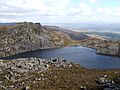
Llyn Du on the northern slopes of Rhinog Fawr
-
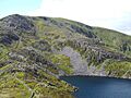
Y Llethr from the slopes of Rhinog Fach
-
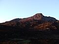
Evening light on Rhinog Fach
-
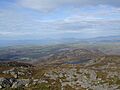
View looking north west from the summit of Rhinog Fawr
-
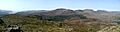
Panorama of the Rhinogau from the summit of Y Garn. You can see the River Mawddach estuary on the far left, and Diffwys, Crib y Rhiw, Y Llethr, Rhinog Fach, and Rhinog Fawr from left to right.


