Y Llethr facts for kids
Quick facts for kids Y Llethr |
|
|---|---|

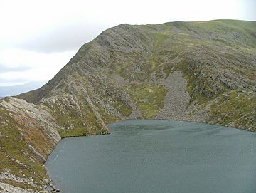
Y Llethr from above Llyn Hywel
|
|
| Highest point | |
| Elevation | 756 m (2,480 ft) |
| Prominence | 561 m (1,841 ft) |
| Parent peak | Moel Siabod |
| Listing | Marilyn, Hewitt, Nuttall |
| Naming | |
| English translation | the slope |
| Language of name | Welsh |
| Geography | |
| Location | Gwynedd, Wales |
| Parent range | Rhinogydd |
| OS grid | SH661258 |
| Topo map | OS Landranger 124 |
Y Llethr is the tallest mountain in the Rhinogydd mountain range. This range is found in Snowdonia, a beautiful national park in north Wales. Standing at 756 meters (about 2,480 feet) high, Y Llethr offers amazing views. Its name means "the slope" in Welsh.
About Y Llethr
Y Llethr is known for its unique top. Unlike some rugged mountains, its highest point is a flat, grassy area. You will find a small pile of stones, called a cairn, marking the very top. The southern parts of the mountain are much smoother than its rougher northern side.
Reaching the Top
The quickest way to climb Y Llethr starts from a valley called Cwm Nantcol in the west. You can go straight up from there. Another path takes you through a pass called Bwlch Drws Ardudwy. From this pass, you then climb over the nearby mountain of Rhinog Fach to reach Y Llethr's summit.
What's Around Y Llethr?
Y Llethr is surrounded by other interesting mountains and hills. To the south, you'll find the mountain of Diffwys. If you look to the south-east, you will see Y Garn. To the north, the mountain of Rhinog Fach stands tall. Finally, to the west, there is the hill of Moelfre.
 | Bayard Rustin |
 | Jeannette Carter |
 | Jeremiah A. Brown |

