
Llandanwg facts for kids
Quick facts for kids Llandanwg |
|
|---|---|
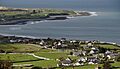
 Llandanwg (left) and Llanfair (right, on the hill) |
|

Llandanwg
|
|
| OS grid reference | SH570285 |
| Community |
|
| Principal area | |
| Ceremonial county | |
| Country | Wales |
| Sovereign state | United Kingdom |
| Post town | HARLECH |
| Postcode district | LL46 |
| Dialling code | 01341 |
| Police | North Wales |
| Fire | North Wales |
| Ambulance | Welsh |
| EU Parliament | Wales |
| UK Parliament |
|
| Welsh Assembly |
|
Llandanwg () is a small village located in Gwynedd, Wales. It's part of the Llanfair area, right by the coast. This village is special because it has its own railway station and a very old church that's been around since the Middle Ages!
Contents
Exploring Llandanwg Village
Llandanwg is found on the coast, west of the A496 coastal road. It sits between the towns of Llanbedr and Harlech. The village is also very close to Llanfair.
Originally, Llandanwg was just a few farms. These farms were located north of the river Artro, near where it flows into the sea. Over time, the village grew bigger with new buildings.
Getting Around: The Railway Station
The village has its own railway station, called Llandanwg Halt. Trains on the Cambrian Line will stop here if you ask them to. In 2015, a new evening train service started. However, it didn't stop at Llandanwg, which made some local people upset.
Fun at the Beach
Llandanwg has a lovely beach that's easy to get to. It's a sloping beach right at the end of the village road. This beach is part of the beautiful Snowdonia National Park.
Close by is Mochras, also known as Shell Island. You can reach it by a special path called a causeway. But be careful, you can only cross to Shell Island when the tide is low! The Llandanwg Holiday Home Park offers holiday homes on a hill above the village. From there, you can see amazing views over Tremadog Bay.
The Ancient Church of Saint Tanwg
The parish church of Saint Tanwg is very unique. It's located right behind the beach, nestled in the sand dunes. It's only about 20 meters from the high tide mark!
This church is from the Middle Ages, probably built in the 1200s. But inside, there are even older stones. Some stones have writings from the 5th or 6th century. Others have crosses carved into them. This tells us that people have been worshipping here for a very long time. It might have been a sacred place as early as the 400s!
Much of the churchyard, where people are buried, is covered in sand. It also holds the war graves of two soldiers from World War I. The church is considered a "Grade II listed building". This means it's an important historic building that needs to be protected.
Images for kids
-
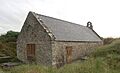
Llandanwg church from the churchyard
-
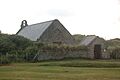
Llandanwg church from Y Maes
-
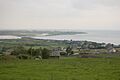
Llandanwg viewed from above the main road with Mochras (Shell Island) in the background
-
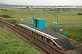
Llandanwg Halt, a design typical of the Cambrian line. The Great Western opened many such halts between 1923 and 1935 along this line similar to this one.
-
Llandanwg and Shell Island from the north


