
River Artro facts for kids
Quick facts for kids River Artro |
|
|---|---|

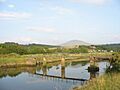
Footbridge over the lower Artro
|
|
| Native name | Afon Artro |
| Country | Wales |
| Physical characteristics | |
| Main source | Llyn Cwm Bychan |
| Length | 4.5 mi (7.2 km) |
The River Artro (called Afon Artro in Welsh) is a river found in Gwynedd, Wales. It is a natural waterway that flows through a beautiful part of the country.
Contents
What is the River Artro?
The River Artro is about 4.5 miles (7.2 km) long. This makes it a fairly short river. It starts high up in the mountains. Its journey begins at a lake called Llyn Cwm Bychan. This lake is located below two mountains, Rhinog Fawr and Moel Ysgyfarnogod.
The River's Journey
From its source, the River Artro flows mainly towards the west. Along its path, another river joins it. This joining river is called the Afon Cwmnantcol. They meet near a place known as Pentre Gwynfryn.
The Artro then continues its flow. It passes right through the middle of the village of Llanbedr. After Llanbedr, the river changes direction. It turns north and flows past Pensarn Wharf.
Where the River Meets the Sea
The River Artro eventually reaches the sea. It flows into a large tidal estuary. An estuary is where a river meets the ocean. Here, fresh river water mixes with salty sea water. This estuary is located between Llandanwg and Mochras/Shell Island.
How the Estuary Changed
The way the Artro estuary looks today is different from the past. In 1819, a person called the Earl of Winchilsea changed the river's path. He did this to make it easier for ships to reach the wharf at Pensarn. A wharf is like a dock where boats can load and unload goods.
This wharf was important for shipping slate. Slate is a type of rock used for roofing and other building materials. It came from nearby areas like Llanfair and Llanbedr. Before this change, the River Artro entered the sea further south of Mochras.
Images for kids
-
A footbridge crosses the lower part of the River Artro.
