Foel Penolau facts for kids
Quick facts for kids Foel Penolau |
|
|---|---|

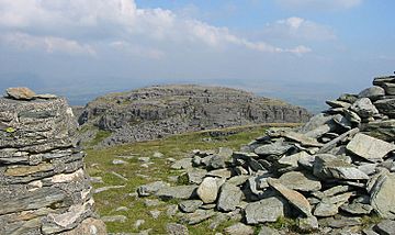
Foel Penolau from the summit of Moel Ysgyfarnogod
|
|
| Highest point | |
| Elevation | 614 m (2,014 ft) |
| Prominence | 32 m (105 ft) |
| Parent peak | Moel Ysgyfarnogod |
| Listing | Simm, Hewitt, Nuttall |
| Naming | |
| English translation | bare hill with light top |
| Language of name | Welsh |
| Geography | |
| Location | Gwynedd, Wales |
| Parent range | Rhinogydd |
| OS grid | SH661348 |
| Topo map | OS Landranger 124 |
Foel Penolau is a mountain in Snowdonia, North Wales. It is found close to another mountain called Moel Ysgyfarnogod. Foel Penolau is the most northern peak in the Rhinogydd mountain range. It also looks over a lake called Llyn Trawsfynydd.
About Foel Penolau
From the top of Foel Penolau, you can see the towns of Porthmadog and Blaenau Ffestiniog. This mountain became more important in December 2018. This was after a new check of its height and shape. It gained "Hewitt" and "Simm" status. These are special lists for mountains in the British Isles. A mountain gets this status if its "prominence" is above 30 metres. Prominence means how much a peak stands out from the land around it.
Climbing to the Top
The very top of Foel Penolau is known for being very rocky. In fact, it is said to be one of the rockiest summits in all of Snowdonia. To reach the highest point, you might need to use your hands to help you climb. The actual summit is a large, smooth slab of rock. This rock is part of the natural outcrop that formed the mountain's peak.
 | Roy Wilkins |
 | John Lewis |
 | Linda Carol Brown |

