
Kilmashogue facts for kids
Quick facts for kids Kilmashogue |
|
|---|---|
| Cill Mochióg | |

Kilmashogue Mountain viewed from the southeast
|
|
| Highest point | |
| Elevation | 408 m (1,339 ft) |
| Geography | |

Kilmashogue
Location in Dublin

Kilmashogue
Location in island of Ireland
|
|
| Location | Dún Laoghaire–Rathdown, Ireland |
| Parent range | Dublin Mountains |
| OSI/OSNI grid | O157236 |
| Topo map | OSI Discovery #50 |
Kilmashogue (also spelled Kilmashoge) is a mountain in Dún Laoghaire–Rathdown county, Ireland. It's about 408 meters (1,339 feet) tall. Kilmashogue is part of a group of hills in the Dublin Mountains, which includes Two Rock, Three Rock, and Tibradden.
On its northern side, you'll find a forest with trees like Sitka spruce, Scots pine, and beech. This forest is home to animals such as Sika deer, hares, rabbits, and foxes. You can also find several ancient monuments on the mountain's slopes.
Coillte, the company that manages the forests in Ireland, thinks the name Kilmashogue comes from old Irish words. It might mean "wood of the ash" (coill na fumsaoige) or "wood of the lark" (coill na fuiseoige).
Contents
History of Kilmashogue Mountain
For a long time, people thought Kilmashogue was where a big battle happened in 917 AD between the Irish and the Vikings. This battle is mentioned in old Irish records called the Annals of the Four Masters. However, later research showed that the battle actually took place closer to the River Liffey.
Ancient Burial Sites: Wedge Tomb
On the northern slopes of Kilmashogue, near a car park, you can find the remains of an ancient wedge tomb. This type of tomb was used to bury people long ago. It was dug up and studied in 1953 by archaeologists.
The tomb has two chambers, which were once covered by a pile of stones called a cairn. Many of these stones were later used to build nearby stone walls. The main chamber is about 4 meters (13 feet) long and 1.5 meters (5 feet) wide. It has a special triple-walled design, which is quite rare for wedge tombs. This tomb faces towards Montpelier Hill, where another ancient burial site once stood.
During the Bronze Age, parts of this tomb were taken apart. The stones were then used to build three smaller stone-lined burial boxes called cists. These cists were placed inside the remaining cairn. When the tomb was excavated, archaeologists found ancient pottery inside these cists.
Calbeck's Castle: A Ruined House
Between Kilmashogue and Tibradden Mountains is a place called Kelly's Glen. Around 1748, a natural spring with special water (a spa) was found here. But it was hard to get to, so it never became very popular.
On the southeastern slopes of Kilmashogue, there's a ruin known as Calbeck's Castle. Despite its name, it wasn't a real castle. It was a small house built around 1800 for people visiting the spa. By 1821, it was already falling apart. The land around here belonged to a man named Councillor Charles Calbeck. He invested a lot in his land, planting trees, building roads and bridges, and improving drainage. Two bridges he built even have messages dedicated to his sister, Sophannie.
Larch Hill: A Scouting Center
Also in Kelly's Glen is the Larch Hill estate. This property was built in the late 1700s by Councillor Calbeck. It's famous for being the first place in Ireland where the British larch tree was planted.
In 1939, the Catholic Boy Scouts of Ireland took over Larch Hill. They have used it as a camp and training center ever since. In one of the fields at Larch Hill, there's a portal tomb. This is another type of ancient monument, but its supporting stones have fallen, causing it to collapse. Only one tall stone, about 3.5 meters (11.5 feet) high, is still standing. Around the monument, there are large boulders almost completely buried. These probably formed a circle of standing stones long ago.
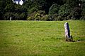
Standing Stones on the Slopes
On the northwestern slopes of Kilmashogue, near the village of Rockbrook, you can find two standing stones. These tall, square stones are about 1.8 meters (6 feet) high. Another standing stone, about 1.4 meters (4.5 feet) tall, is also nearby.
The Brehon's Chair: Another Ancient Tomb
Further down the northern slopes, in a housing area near Marlay Park, is another portal tomb called the "Brehon's Chair." Only three large stones remain. These were originally the door stone and two portal stones of the monument. One of them is about 3 meters (10 feet) tall. The name "Brehon's Chair" was given to it in the late 1700s or early 1800s. At that time, people thought all such ancient monuments were connected to the Druids.
When the M50 motorway was being built nearby, archaeologists found cooking areas and old hut sites around the Brehon's Chair. They also found another ancient pot used for burials. Sadly, a similar monument nearby was destroyed in 1876.
St Columba's College: A Historic School
On Kilmashogue Lane, you'll find St Columba's College, a Protestant boarding school. It was first known as Hollypark and was built in the late 1700s by Gerald Foot, a rich merchant. The school itself was founded in 1843 in County Meath and moved to this location in 1849.
Inside the college chapel, there is an early Christian cross that was found on the mountain. An old book from 1905 mentions that the boundary of The Pale (an area controlled by the English in medieval Ireland) ran along the northern slopes of Kilmashogue near the college. It also said that the remains of a castle, once owned by the Harold family, could be found nearby. Across from the college are the ruins of an old wool factory that operated until 1880.
Visiting Kilmashogue Mountain
The very top of Kilmashogue Mountain is on private land. However, there is a forest recreation area on the northern slopes, managed by Coillte and the Dublin Mountains Partnership. This area is open to the public.
The Wicklow Way, a popular long-distance walking trail, passes through this recreation area. From here, you can also easily reach Three Rock and Tibradden Mountains. The ancient wedge tomb can be reached by following a trail uphill from the car park in the recreation area. The portal tomb at Larch Hill and the Brehon's Chair are on private land.
Images for kids
-
Kilmashogue standing stones

