
Two Rock facts for kids
Quick facts for kids Two Rock Mountain (Binn Dá Charraig) |
|
|---|---|
| Black Mountain; Sliab Lecga | |

Two Rock from the south
|
|
| Highest point | |
| Elevation | 536 m (1,759 ft) |
| Prominence | 171 m (561 ft) |
| Listing | Marilyn (hill) |
| Geography | |

Two Rock Mountain
Location in Dublin

Two Rock Mountain
Location in island of Ireland
|
|
| Location | Dún Laoghaire–Rathdown, Ireland |
| Parent range | Dublin Mountains |
| OSI/OSNI grid | O1721922374 |
| Topo map | OSi Discovery Series No. 50 |
Two Rock (also known as Binn Dá Charraig in Irish) is a mountain in Dún Laoghaire–Rathdown, Ireland. It stands 536 metres (1,759 feet) tall, making it one of Ireland's highest mountains. Two Rock is the highest point in a group of hills called the Dublin Mountains. This group includes nearby peaks like Three Rock, Kilmashogue, and Tibradden Mountains.
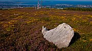
The mountain gets its name from two large, rocky outcrops called tors. These tors are made of granite and can be seen on the mountain's southeast side. The very top of Two Rock is known as Fairy Castle. From here, you can see amazing views of the Dublin area, from Tallaght to Howth. You can also spot other famous landmarks like Bray Head, Killiney Hill, the Great Sugar Loaf, and the Wicklow Mountains to the south. The top of the mountain is mostly covered in shallow bog, which is a type of wet, spongy ground. Lower down, you'll find lots of ferns and gorse plants. Two Rock Mountain is also an important home for red grouse, a type of bird.
You can find several ancient monuments on the mountain. These include a special burial site called a passage tomb at the summit and another type of tomb called a wedge tomb on the lower slopes near Ballyedmonduff.
Contents
Exploring Two Rock Mountain
Fairy Castle: The Summit Tomb
The very top of Two Rock Mountain is called Fairy Castle. Here, you'll see a pile of stones known as a cairn and a trig pillar. A trig pillar is a special marker used by mapmakers to measure heights and distances. Both of these sit on top of a round structure made of granite and quartz rocks. This structure is about 25 metres (82 feet) wide and 2 metres (6.6 feet) high, covered with grass and plants.
This large mound is actually what's left of an ancient passage tomb. A passage tomb is a prehistoric burial chamber that people built thousands of years ago. This one is the most eastern of many such tombs found across the Dublin and West Wicklow Mountains. The entrance to the tomb used to be visible, and locals even called it a "cave." However, the edges of the stone pile have collapsed over time, so you can't see the entrance anymore. Even though there's no proof the tomb has ever been opened, archaeologists believe it holds a small burial room inside.
Ballyedmonduff Wedge Tomb: The Giant's Grave
In a forest area southeast of the summit, near a place called Ballyedmonduff, you can find a Bronze Age wedge tomb. This tomb is often called the "Giant's Grave." It's considered one of the best examples of a wedge tomb in all of Ireland. An old expert named John O'Donovan once said he hadn't seen such a perfect ancient grave anywhere else.
The tomb looks different today than it did when it was first found. Old drawings from the 1830s show it as a grassy mound. Another drawing shows that its roof was partly still there back then. Also, the pine forest that now surrounds the tomb blocks the views of the Great Sugar Loaf mountain and the two tors of Two Rock that people could see from this spot in the past.
The tomb was first opened in 1832, but no one kept a record of what was found. However, when John O'Donovan visited, local people told him that ashes had been discovered when the grave was opened. After it was opened, many of the larger stones were taken away by local stonecutters.
The site was dug up again in 1945 by archaeologists Seán P. Ó Riordáin and Rúaidhri de Valera. They found pieces of decorated Beaker pottery, a smooth hammer, a possible polishing stone, and a flint scraper. They also found a small amount of human bone that had been burned. After this dig, the monument was rebuilt to look like it does today.
The tomb has a burial area over 6 metres (20 feet) long, divided into three rooms. It's surrounded by a horseshoe shape of stones with a straight front at the western end. At the southern end, there's a long stone with seven cupmarks on it. Cupmarks are small, round hollows carved into rock, a type of rock art usually linked to even older Stone Age cultures. This stone might have been a natural boulder brought to the site when the tomb was built.
Other Ancient Sites
There was once another large stone tomb, known as The Greyhound's Bed, on the southern slopes of Two Rock. It was located near the R116 road between the villages of Glencullen and Brockey. In 1836, an expert named Eugene O'Curry described it as a long stone 10 feet (3.0 metres) long by 7 feet (2.1 metres) wide. A sketch of it was made in 1855 before the monument was destroyed.
You can also find a triangular-shaped standing stone on the mountain. It's about 1 metre (3.3 feet) high and located about 400 metres (1,300 feet) north-northeast of Fairy Castle, on the slope leading towards Three Rock.
Visiting Two Rock Mountain
Two Rock Mountain is a great place for outdoor activities. You can reach it through forest areas like Ticknock, Kilmashogue, and Tibradden. These areas are owned by Coillte and managed by the Dublin Mountains Partnership, which helps people enjoy the mountains.
The mountain is crossed by the Dublin Mountains Way, a popular hiking trail that goes between Shankill and Tallaght. Another hiking trail, the Wicklow Way, runs to the west of the summit. These trails offer fantastic opportunities for walking and exploring the beautiful scenery.
Images for kids
-
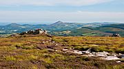
The two tors that give Two Rock its name
-
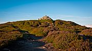
Fairy Castle: the mound on which the cairn and trig pillar sit is a passage grave
-
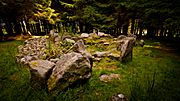
Ballyedmonduff wedge tomb
-
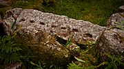
Rock art at Ballyedmonduff wedge tomb
-
Standing stone on the north-northeast slopes


