
Glenmacnass Waterfall facts for kids
Quick facts for kids Glenmacnass Waterfall |
|
|---|---|
| Gleann Log an Easa | |
 |
|
| Lua error in Module:Infobox_mapframe at line 185: attempt to index field 'wikibase' (a nil value). | |
| Location | Wicklow Mountains, Ireland |
| Coordinates | 53°03′51″N 6°20′13″W / 53.064223°N 6.33688°W |
| Type | Cascade |
| Elevation | 350 metres (1,150 ft) |
| Total height | 80 metres (260 ft) |
| Number of drops | 3 |
| Watercourse | Glenmacnass River |
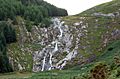
Glenmacnass Waterfall is a beautiful 80-meter high waterfall in the Wicklow Mountains of Ireland. Its name in Irish, Gleann Log an Easa, means "the glen of the hollow of the waterfall". This amazing waterfall is a popular spot for tourists and offers great views of the surrounding area.
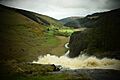
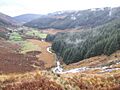
The waterfall is located at the top of the Glenmacnass Valley. To its west is Tonelagee mountain, and to its east is Scarr mountain. You can reach the entire Glenmacnass Valley using the R115 road. This road is also known as the Military Road. It connects the Sally Gap in the north to the village of Laragh in the south.
Contents
Journey of the Glenmacnass River
The Glenmacnass River starts high up on the slopes of Mullaghcleevaun mountain, which is about 849 meters (2,785 feet) tall. Smaller streams also flow into it from the eastern side of Tonelagee mountain, which is 817 meters (2,680 feet) high.
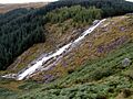
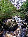
The river reaches the top of the waterfall at an elevation of 350 meters (1,148 feet) above sea level. From there, it drops 80 meters (262 feet) down the waterfall in three separate steps. It finally reaches the Glenmacnass Valley floor at an elevation of 270 meters (886 feet).
The river then continues its journey through the valley. It eventually joins the Avonmore River near the village of Laragh. The Avonmore River's name means "big river" in Irish. Later, the Avonbeg River, meaning "small river," joins it. Together, they become the Avoca River. This river then flows into the Irish Sea at the coastal town of Arklow.
How the Valley Was Formed
The Geological Survey of Ireland (GSI) describes the Glenmacnass Valley as a "stunning example" of a U-shaped valley. This type of valley is created by glaciers. It has steep cliff sides and a flat bottom.
The valley was formed during the last Ice Age, also known as the Quaternary glaciation. You can still see moraines in the valley. Moraines are piles of rocks and dirt left behind by glaciers. They show where the edge of the ice once was as it melted and moved back.
The GSI points out a very clear moraine about halfway between the waterfall and Laragh. It looks like a mound covered in boulders stretching across the valley.
Glenmacnass Waterfall flows over a type of rock called grey porphyritic granite. This granite is part of a larger rock formation called the Lugnaquilla pluton. This formation is from a very old period, about 405 million years ago.
Further down the valley, on both sides of the waterfall, you can see dark grey-to-black, jagged schist rock. This rock is part of the Maulin Formation. The waterfall actually formed right where these two different types of rock meet.
Visiting the Waterfall
Glenmacnass Waterfall is a very popular place for visitors. It's known for its beautiful scenery in the Wicklow Mountains. The entire Glenmacnass Valley is easy to get to by car using the R115 road, also known as the Military Road.
This road connects the Sally Gap in the north to Laragh in the south. There are places to park your car right at the top of the waterfall. The waterfall and the valley are part of the Wicklow Mountains National Park, which helps protect this natural beauty.
Images for kids
-
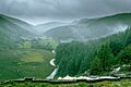
Mist on the waterfall
-
From south
-
Heavy flow
-
From Military Road
-
Glenmacnass valley
-
Glenmacnass River above Laragh


