
Scarr facts for kids
Quick facts for kids Scarr |
|
|---|---|
| Sceir or Scor | |

Distinctive peak of Scarr, viewed from the R759 above the Luggala Estate
|
|
| Highest point | |
| Elevation | 641 m (2,103 ft) |
| Prominence | 231 m (758 ft) |
| Listing | Marilyn, Hewitt, Arderin, Simm, Vandeleur-Lynam |
| Naming | |
| English translation | sharp rock |
| Language of name | Irish |
| Geography | |

Scarr
Location in island of Ireland
|
|
| Location | County Wicklow, Republic of Ireland |
| Parent range | Wicklow Mountains |
| OSI/OSNI grid | O1326801828 |
| Topo map | OSi Discovery 56 |
| Geology | |
| Mountain type | Dark blue-grey slate, phyllite & schist |
| Climbing | |
| Easiest route | Via Oldbridge at Lough Dan |
Scarr (which means Sceir or Scor in Irish, meaning "sharp rock") is a mountain in County Wicklow, Republic of Ireland. It stands at 641 metres (2,103 ft) tall. This makes it one of the higher peaks in Ireland. On different lists of mountains, Scarr ranks as the 174th-highest on the Arderin scale and the 207th-highest on the Vandeleur-Lynam scale.
Scarr is located in the middle part of the Wicklow Mountains. It's a bit separate from the main line of mountains that stretches from Kippure in the north to Lugnaquilla in the south. Scarr has its own group of smaller peaks around it. These include Scarr North-West Top (561 metres (1,841 ft)) and Kanturk (523 metres (1,716 ft)).
To the east of Scarr, you'll find Lough Dan, a beautiful lake. To the west is the Glenmacnass Valley. Scarr's top looks very sharp and pointy. This makes it stand out from the other mountains in the Wicklow range, which often have more rounded tops. Scarr also creates a stunning background for the views over the Guinness Estate and Lough Dan.
Exploring Scarr Mountain
Scarr Mountain is a great place for people who enjoy walking and hiking. Its unique shape and surrounding landscapes make it a popular spot for outdoor adventures.
Popular Hiking Trails
One well-liked hiking path is the Scarr and Kanturk Loop walk. This trail is about 14 kilometers (around 8.7 miles) long and usually takes 4 to 5 hours to complete. It begins at a parking area near Oldbridge (O158019), which is at the southern end of Lough Dan.
Hikers often choose to walk this loop in a counter-clockwise direction. This means they first climb to the top of Kanturk mountain. After reaching Kanturk's summit, they cross over to the top of Scarr. Finally, they return to Oldbridge, completing the loop. This route offers amazing views and a good challenge for walkers.
Images for kids
-
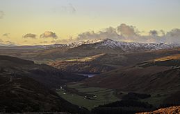
Scarr in Winter
-
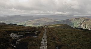
Scarr (left) from White Hill boardwalk on Djouce
-
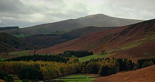
From the Guinness Estate
-
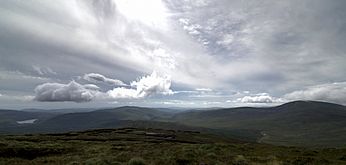
Lough Dan, Scarr, and Tonelagee, from Mullaghcleevaun


