
Tonelagee facts for kids
Quick facts for kids Tonelagee |
|
|---|---|
| Tóin le Gaoith | |

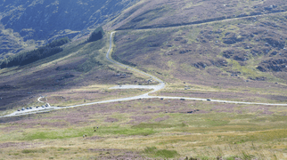
Tonelagee from the Glendasan River
|
|
| Highest point | |
| Elevation | 817 m (2,680 ft) |
| Prominence | 202 m (663 ft) |
| Listing | 100 Highest Irish Mountains, Marilyn, Hewitt, Arderin, Simm, Vandeleur-Lynam |
| Naming | |
| English translation | backside to the wind |
| Language of name | Irish |
| Geography | |

Tonelagee
Location in island of Ireland
|
|
| Location | County Wicklow, Republic of Ireland |
| Parent range | Wicklow Mountains |
| OSI/OSNI grid | O0850301589 |
| Topo map | OSi Discovery 56 |
| Geology | |
| Mountain type | Adamellite with microcline phenocrysts |
| Climbing | |
| Easiest route | From a car park at the top of nearby Glenmacnas Waterfall (on the Sally Gap side) where there are routes to the summit on either side of the lake and stream. |
Tonelagee (which means Tóin le Gaoith or "backside to the wind" in Irish) is a tall mountain in Ireland. It stands at 817 meters (2,680 feet) high. This makes it the 25th highest peak in Ireland on one list, and the 33rd highest on another.
Tonelagee is found in the middle part of the Wicklow Mountains range. It sits on the main "central spine" of these mountains. This spine stretches from Kippure in the north to Lugnaquilla in the south. Tonelagee is the third highest mountain in County Wicklow, after Lugnaquilla and Mullaghcleevaun.
To the north of Tonelagee, there is a smaller peak called Stoney Top (714 meters or 2,343 feet). To the east, you'll find another smaller peak, Tonelagee NE Top (668 meters or 2,192 feet). Between these three peaks is a deep, heart-shaped lake called Lough Ouler.
Contents
What's in a Name?
The name Tonelagee comes from the Irish words Tóin le Gaoith. This means "backside to the wind." It's a bit of a funny name! Some other places in Ireland, like Tandragee, also have "Tóin le Gaoith" in their names. Experts aren't sure why these places share a name related to the wind.
There isn't much information about other Irish names for Stoney Top. However, there is an old standing stone with a cross carved into it. This stone is located between Stoney Top and the main summit of Tonelagee.
Exploring Tonelagee's Geography
Tonelagee is the third tallest mountain in the Wicklow Mountains. It is located in the southern part of the central section of the range. The mountain is part of a long, boggy ridge. This ridge runs from the Sally Gap in the north, past Mullaghcleevaun, and ends at Tonelagee.
One of Tonelagee's most special features is a deep, bowl-shaped valley on its northeast side. This valley is called a corrie. Inside this corrie is the beautiful, heart-shaped lake known as Lough Ouler. The lake sits at 596 meters (1,955 feet) above sea level. It's a bit lower than Wicklow's highest natural lake, Cleevaun Lough, which is on Mullaghcleevaun.
Hiking Tonelagee
Many people enjoy hiking to the top of Tonelagee. A popular way to do this is an 8-kilometer (5-mile) loop walk. This hike usually takes about 3 to 4 hours.
Starting Your Hike
You can start this walk from a large car park. This car park is located just above Glenmacnass Waterfall. It's off the R115 road, also known as the Old Military Road.
The Route to the Summit
From the car park, you will cross the Glenmacnass River. Then, you will reach Tonelagee's northeast corrie and Lough Ouler. The path then goes up along the northern edge of the corrie rim. This leads you to the summit of Tonelagee. Along the way, you might see the old standing stone.
The Way Down
To get back down, you can go via Tonelagee NE Top. From there, you head directly down to the shoulder of the mountain. This path will take you back to the Glenmacnass Waterfall car park. It's a great way to see the mountain's famous heart-shaped lake!
Gallery
-
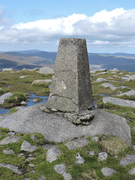
Summit pillar
-
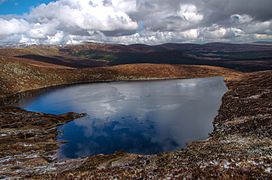
Heart-shaped Lough Ouler
-
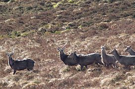
Deer on Tonelagee
-
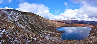
North-east corrie and Lough Ouler
-
Wicklow Gap on slopes of Tonelagee


