
Mullaghcleevaun facts for kids
Quick facts for kids Mullaghcleevaun |
|
|---|---|
| Mullach Cliabháin | |

Summit and northern corrie of Lough Cleevaun
|
|
| Highest point | |
| Elevation | 849 m (2,785 ft) |
| Prominence | 374 m (1,227 ft) |
| Listing | 100 Highest Irish Mountains, Hewitt, Marilyn, Arderin, Simm, Vandeleur-Lynam |
| Naming | |
| English translation | summit of the cradle/basket |
| Language of name | Irish |
| Geography | |

Mullaghcleevaun
Location in island of Ireland
|
|
| Location | Wicklow, Republic of Ireland |
| Parent range | Wicklow Mountains |
| OSI/OSNI grid | O0676307049 |
| Topo map | OSi Discovery 56 |
| Geology | |
| Type of rock | Granite with microcline phenocrysts |
Mullaghcleevaun (which means "summit of the cradle/basket" in Irish) is a tall mountain in Ireland. It stands at 849 metres (2,785 ft) high. This makes it the 15th highest peak in Ireland on one list (the Arderin scale). It's also the 20th highest on another list (the Vandeleur-Lynam scale).
Mullaghcleevaun is found in the middle part of the Wicklow Mountains range. This range is in Wicklow, Ireland. It is the second highest mountain in Wicklow, right after Lugnaquilla. Mullaghcleevaun is part of the main "central spine" of the Wicklow Mountains. This spine stretches from Kippure in the north to Lugnaquilla in the south.
Just east of the main summit is Mullaghcleevaun East Top, which is 790 metres (2,590 ft) tall. Below the main summit, you'll find Cleevaun Lough. This is Wicklow's highest natural lake, sitting at 686 metres (2,251 ft).
Contents
What does Mullaghcleevaun mean?
The name Mullaghcleevaun comes from the Irish language. It means "summit of the cradle" or "summit of the basket".
According to an Irish expert named Paul Tempan, the name likely comes from a "cradle-like dip" near the top of the mountain. This dip is probably where Cleevaun Lough is located.
Where is Mullaghcleevaun located?
Mullaghcleevaun is the second highest mountain in the Wicklow Mountains. It is located in the central part of this mountain range. The mountain sits on the western edge, looking over the Poulaphouca Reservoir. This reservoir is also known as the "Blessington Lakes".
The mountain's height above the land around it, called its prominence, is 374 metres (1,227 ft). This makes it the 8th highest mountain in Ireland on the MountainViews Online Database list. This list includes mountains that are at least 100 meters prominent.
Mullaghcleevaun has a flat top that you can see from other mountains nearby. Its larger area, called a massif, includes other smaller peaks. One of these is Mullaghcleevaun East Top, which is 790 metres (2,590 ft) high. Another is Carrigshouk, at 573 metres (1,880 ft), located to the south-east. Further north on the massif is Duff Hill, which is 720 metres (2,360 ft) tall.
What are Mullaghcleevaun's special features?
One of the most interesting parts of Mullaghcleevaun is its deep northern corrie. A corrie is a bowl-shaped hollow formed by glaciers. This corrie holds Wicklow's highest natural lake, Lough Cleevaun, at 686 metres (2,251 ft).
The southeastern slopes of Mullaghcleevaun are where the Glenmacnass River begins. This river flows down the Glenmacnass Waterfall into the Glenmacnass Valley. From there, it continues to Laragh.
How can you hike Mullaghcleevaun?
Many people enjoy hiking to the top of Mullaghcleevaun. A popular way to reach the summit is from the south. This walk is about 8.5 kilometers long and takes 3 to 4 hours.
The hike starts from a small car park in the forest. This car park is below Carraigshouk (572 metres (1,877 ft)) and is known as "The Oasis". It's just off the R115 road, also called the Old Military Road. This southern route goes up to Mullaghcleevaun East Top first, then to the main summit of Mullaghcleevaun. After reaching the top, hikers usually return the same way to the car park.
You can also start a similar length hike from the north. This route begins at the car park in Ballynultagh Gap. This gap is located between Black Hill and Sorrel Hill.
A longer and more challenging hike is to walk the entire "boggy ridge" from the north-east to the south-west. This path starts from the Sally Gap. It then goes to Carrigvore (682 metres (2,238 ft)) and then to Gravale (718 metres (2,356 ft)). After a dip in the land, the ridge continues south-west to Duff Hill (720 metres (2,360 ft)). Finally, it reaches Mullaghcleevaun East Top and Mullaghcleevaun itself. Walking from the Sally Gap to Mullaghcleevaun is about 8.5 kilometers and takes 3 to 4 hours. Some hikers use two cars to avoid walking all the way back, which would make it a 7-hour hike.
Images for kids
-
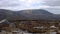
Northern corrie
-
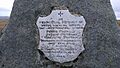
An Oige memorial plaque
-
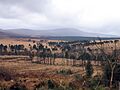
From the R759
-
Northern corrie, winter
-
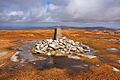
Summit cairn
-
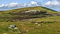
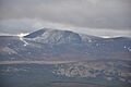
View from the East
-
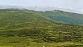
View from the south of Mullaghcleevaun


