
Lough Dan facts for kids
Quick facts for kids Lough DanLoch Deán |
|
|---|---|
.jpg)
Looking south-east
|
|

Lough Dan
Location in Ireland
|
|
| Location | County Wicklow |
| Coordinates | 53°04′32″N 6°17′09″W / 53.075436°N 6.285918°W |
| Primary inflows | River Cloghoge, River Inchavore |
| Primary outflows | River Avonmore |
| Catchment area | 63.18 km2 (24.39 sq mi) |
| Basin countries | Ireland |
| Max. length | 3 km (1.9 mi) |
| Max. width | 0.5 km (0.31 mi) |
| Surface area | 1.03 km2 (0.40 sq mi) |
| Average depth | 13.5 m (44 ft) |
| Surface elevation | 200 m (660 ft) |
| Islands | none |
Lough Dan (which means Loch Deán in Irish) is a beautiful lake in the Wicklow Mountains in Ireland. It looks a bit like a boomerang! The lake is mostly on private land.
Lough Dan sits at the bottom of two mountains: Luggala, which is 595 metres (1,952 ft) tall, and Knocknacloghoge, which is 534 metres (1,752 ft) tall.
About Lough Dan
Lough Dan is a special type of lake called a "ribbon lake." This means it's long and narrow, often found in valleys that were carved out by glaciers a long, long time ago.
Where is it?
The lake gets its water from two rivers: the Cloghoge River and the Inchavore River. The Cloghoge River actually flows out of another lake called Lough Tay. Lough Dan then drains into the River Avonmore to the south.
Most of the land around Lough Dan is privately owned. This means public access is limited in some areas. However, the north-western part of the lake is inside the Wicklow National Park, which is open to everyone.
Fun for Scouts!
Did you know that a national campsite for Scouting Ireland is located right next to Lough Dan? It's a popular spot for scouts from all over Ireland.
What is a Jamboree?
In 1997, Lough Dan was the location for a big Scouting event called a "jamboree." A jamboree is a huge gathering of scouts from different groups or even different countries. They camp together, learn new skills, and have lots of fun activities.
The jamboree at Lough Dan in 1997 was called Lough Dan '97. Sadly, it had to end early because of very bad weather and flooding. Even so, it was a memorable event for the scouts who were there!
Images for kids
-
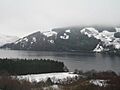
Snow around Lough Dan
-
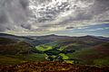
Looking north from west bank
-
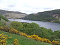
Looking south-east from west bank
-
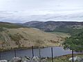
Cloghoge River between Lough Tay and Lough Dan
.jpg)


