River Derry facts for kids
Quick facts for kids River DerryAn Doiríoch |
|
|---|---|

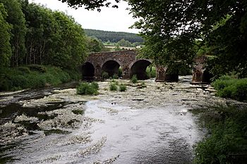
The Derry flows under Clonegal Bridge
|
|
| Physical characteristics | |
| Main source | East of Eagle Hill, near Hacketstown, County Carlow 349 metres (1,145 ft) |
| River mouth | River Slaney Kildavin, County Carlow |
| Length | 34 kilometres (21 mi) |
| Basin features | |
| River system | Slaney |
The River Derry (Irish: An Doiríoch) is an important river in the southeast of Leinster, Ireland. It is a branch, or tributary, of the larger River Slaney. The River Derry starts its journey just south of Hacketstown in County Carlow, Ireland.
The River's Journey
The River Derry flows for about 34 kilometers (21 miles). It begins in County Carlow and then travels southeast towards a town called Tinahely. For part of this journey, the river flows alongside the R747 regional road.
Changing Direction
South of Tinahely, the river makes a sharp turn. It then flows southwest through a place called Shillelagh. As it flows, the River Derry briefly forms a natural border. It separates County Wicklow from County Wexford. After that, it becomes the border between County Wexford and County Carlow.
Flowing Under Bridges
The River Derry flows under the famous Clonegal Bridge. This bridge is a special spot because the river divides two areas. To the west of the river is Clonegal, which is in County Carlow. To the east is Watch House Village, located in County Wexford.
A few kilometers further downstream, the River Derry reaches its end. It flows into the River Slaney, joining its waters.
Derry Water River
It's easy to get confused, but the Derry Water River is a completely separate river. It is not the same as the River Derry. The Derry Water River also starts near Tinahely. However, it flows northeast instead of southwest. This river then helps to form the Aughrim River.
 | Frances Mary Albrier |
 | Whitney Young |
 | Muhammad Ali |


