
Crone Woods facts for kids
Quick facts for kids Crone Woods |
|
|---|---|

Entrance car park
|
|
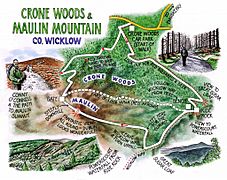
| Map | |

Location in island of Ireland
|
|
| Geography | |
| Location | Wicklow, Leinster, Republic of Ireland |
| OS grid | O1920 1417 |
| Coordinates | 53°09′39″N 6°13′35″W / 53.16096225°N 6.226272243361938°W |
| Elevation | 185 m |
| Administration | |
| Governing body | Coillte |
Crone Woods, also known as Crone Forest, is a beautiful woodland area. You can find it in the northeastern part of the Wicklow Mountains in Wicklow, Ireland. It sits just below the top of a mountain called Maulin, which is about 570 metres (1,870 feet) high.
Crone Woods has many forest paths and trails. These are great for hiking and exploring. You can easily get to these trails from the nearby village of Enniskerry.
Exploring Crone Woods' History and Trails
Crone Woods has a long and interesting past. Long ago, in the 1200s, this area was part of the huge Powerscourt Estate. It was even set aside as a special hunting ground for royalty!
Later, around 1798, there was a time of unrest in Ireland. The woods were used for cover during this period. Because of this, a special military road was built through the northern Wicklow Mountains. This road helped to open up the region and made it easier to travel through.
Today, Crone Woods is owned and managed by Coillte. This is the official Irish government agency for forestry. They help look after the forests across Ireland.
What Can You See and Do in Crone Woods?
There are many trails to explore in Crone Woods. Some paths lead to a spot called 'Ride Rock'. From here, you can see amazing views looking down into Powerscourt Waterfall. Other trails will take you all the way to the top of Maulin mountain.
Crone Woods is also an important starting point for the Wicklow Way. This is the oldest long-distance walking trail in the Republic of Ireland. It stretches for 131 kilometres (81 miles)! The Wicklow Way begins in Marlay Park in South Dublin and ends in Clonegal Village in County Carlow.
Many hikers also use Crone Woods to complete a 16-kilometre (10-mile) loop. This challenging walk goes around several mountains: Maulin, Tonduff (642 m or 2,106 ft), War Hill (686 m or 2,251 ft), and Djouce (725 m or 2,379 ft). This famous route is sometimes called the 'Circuit of Glensoulan'.
Gallery
-
Crone Wood trails
-
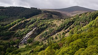
Powerscourt Waterfall and Crone Woods
-
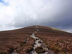
Final path to Maulin from Crone Woods


.jpg)
